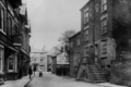
Namesake | St Chad's Church |
---|---|
Length | 0.040 mi (0.064 km) |
Location | Poulton-le-Fylde, Lancashire, England |
North end | Ball Street |
South end | Market Place |
Church Street is a historic street in the market town of Poulton-le-Fylde, Lancashire, England. It runs for about 210 feet (70 yards), from Ball Street in the north to Market Place in the south. An entrance to Poulton's Teanlowe Centre shopping precinct is located where Church Street merges into Market Place. The street was pedestrianised in 1983. [1]
The eastern side of the street forms the western boundary of the raised graveyard of St Chad's Church, for which Church Street is named. In the early 20th century, the row of buildings lining the southern side of Ball Street, and those on the eastern side of Church Street, were demolished, [2] [3] resulting in today's unobsctructed view of St Chad's. Now, between the northern end of the pedestrianised Church Street to the west and the Thatched House (built in 1907) in the east, there are two bus stops along the paved area. [4]
The Old Town Hall public house, built in 1910, stands on Church Street. The Bay Horse Inn stood on the site from 1869. [5]
In 1926, Church Street was listed in The London Gazette as one of the streets of Poulton under which a mains electricity supply was to be installed within a two-year period. [6]
Church Street is part of Wyre Council's Poulton-le-Fylde Conservation Area Appraisal. [7]
Kirkham aka Kirkam-in-Amounderness is a market town and civil parish in the Borough of Fylde in Lancashire, England, midway between Blackpool and Preston and adjacent to the town of Wesham. It owes its existence to Carr Hill upon which it was built and which was the location of a Roman fort. At the census of 2011, it had a population 3,304 plus 3,890, giving a total of 7,194. By the census of 2021 the total had risen to 3,217 plus 4,666, giving a total of 7,883.
Wyre is a local government district with borough status on the coast of Lancashire, England. The council is based in Poulton-le-Fylde and the borough also contains the towns of Cleveleys, Fleetwood, Garstang, Preesall and Thornton, along with numerous villages and surrounding rural areas. Some of the borough's built-up areas form part of the wider Blackpool urban area. Eastern parts of the borough lie within the Forest of Bowland, a designated Area of Outstanding Natural Beauty.
Poulton-le-Fylde, commonly shortened to Poulton, is a market town in Lancashire, England, situated on the coastal plain called the Fylde. In the 2021 United Kingdom census, it had a population of 18,115.
Fleetwood is a coastal town in the Borough of Wyre in Lancashire, England, at the northwest corner of the Fylde. It had a population of 25,939 at the 2011 census.
Hambleton is a village and civil parish in the English county of Lancashire. It is situated on a coastal plain called the Fylde and in an area east of the River Wyre known locally as Over Wyre. Hambleton lies approximately 3 miles (4.8 km) north-east of its post town, Poulton-le-Fylde, and about 7 miles (11 km) north-east of the seaside resort of Blackpool. In the 2001 United Kingdom census, the parish had a population of 2,678, increasing to 2,744 at the 2011 census.
The Fylde is a coastal plain in western Lancashire, England. It is roughly a 13-mile-long (21-kilometre) square-shaped peninsula, bounded by Morecambe Bay to the north, the Ribble estuary to the south, the Irish Sea to the west, and the foot of the Bowland hills to the east which approximates to a section of the M6 motorway and West Coast Main Line.
Poulton-le-Fylde is a market town in the Wyre district of Lancashire, England, situated on a coastal plain called the Fylde. There are 16 buildings and structures in the town which have been listed by the Secretary of State for Culture, Olympics, Media and Sport as being of special architectural, historical or cultural significance. One is classified as Grade II*, and the rest as Grade II; Poulton-le-Fylde has no Grade I listed buildings. The Grade II* designation is for St Chad's Church. There is written evidence of a church on the site since 1094, although it may have been built earlier. It became the Anglican parish church at the time of the Reformation and was largely rebuilt in the 18th century.
St Chad's Church is an Anglican church in Poulton-le-Fylde, Lancashire, England. It is an active parish church in the Diocese of Blackburn and the archdeaconry of Lancaster. It is recorded in the National Heritage List for England as a designated Grade II* listed building. A church on the site was built no later than the 11th century and may have existed prior to the Norman conquest of England. The tower dates from the 17th century, and much of the remainder of the building from a major renovation in the 18th century, although some of the fabric of the original structure remains. Further renovation and additions took place in the 19th, 20th and 21st centuries.
Carleton is a village on the coastal plain of the Fylde in the Borough of Wyre in Lancashire, England. It consists of Great Carleton, Little Carleton, Norcross and Whiteholme and is situated close to Poulton-le-Fylde. Other nearby settlements include Thornton, Bispham and Blackpool. Historically, Carleton was in the parish of Poulton-le-Fylde. It borders the Borough of Blackpool immediately to the west.
Burn Naze is a residential area of Thornton-Cleveleys, in the Borough of Wyre, Lancashire, England. It is located about 5 miles (8 km) northeast of Blackpool and 2 miles (3 km) southeast of Fleetwood. Cleveleys is about 1.3 miles (2.1 km) to the west, while the River Wyre is about 0.8 miles (1.3 km) to the east.
Erected in 1921, the Poulton-le-Fylde War Memorial is located in the English market town of Poulton-le-Fylde, Lancashire. A Grade II listed structure, it stands in a small cobbled area at the north end of Market Place, having been moved from nearby Queen’s Square in 1979. Made of granite, it consists of a pillar with an octagonal foot, and a ball finial surmounted by a wheel-head cross. The pillar is on a square plinth on an octagonal step. On the plinth is a timber plaque with a coat of arms, a bronze plaque with an inscription, and further plaques recording the names of those lost in the World Wars and another conflict.
The Old Town Hall is a building on Church Street in the market town of Poulton-le-Fylde in Lancashire, England. The building, which is located just beyond the northern end of Market Place, started life as a public house before becoming a municipal building and then reverting to use as a public house.
Queen's Square is a formerly open area in the centre of the English market town of Poulton-le-Fylde, Lancashire. It stands today, immediately to the southeast of Market Place, at the convergence of Blackpool Old Road to the west, Chapel Street and Higher Green to the east and Hardhorn Road to the south.
Market Place is a public square in the English market town of Poulton-le-Fylde, Lancashire. Dating to the Middle Ages, it has historically been a site of weekly markets, today taking place on Mondays. It is now mostly used as a shopping precinct, along with the adjacent indoor Teanlowe Centre.
The Golden Ball is a public house and hotel on Ball Street in the English market town of Poulton-le-Fylde, Lancashire. Built in the 19th century, it was originally a coaching inn for travellers making their way to local towns and villages. During the course of its existence, the building has been a police courtroom, a newsroom and a café. Ball Street is named for the pub.
The Thatched House is a public house on Ball Street in the English market town of Poulton-le-Fylde, Lancashire. A former coaching inn, it stands adjacent to the churchyard of St Chad's, at the corner of Chapel Street. A tavern, believed to have been called the Green Man, was on the site in 1793, and may have been built in the Middle Ages.
Ball Street is a historic street in the market town of Poulton-le-Fylde, Lancashire, England. It runs for about 300 feet (100 yd), from the junction of Chapel Street, Vicarage Road and Breck Road in the east to its convergence with Tithebarn Street in the west. It is one-way westbound. The street, which is the start or end of today's B5267, has existed since at least the 19th century, which is when the Golden Ball public house was built.
The Bull is a public house on Blackpool Old Road in the English market town of Poulton-le-Fylde, Lancashire. The original pub, named The Black Bull Inn, was built in the 19th century and gave its name to the street on which it stood. Bull Street was renamed Blackpool Old Road in the 20th century. The pub was rebuilt in 1963.
Breck Road is a road in Poulton-le-Fylde, Lancashire, England. Originally known as Breck Street, it runs for about 0.79 miles (1.27 km) from Chapel Street, Ball Street and Vicarage Road in the south to Amounderness Way in the north.
2 Market Place is a Grade II listed building in the English market town of Poulton-le-Fylde, Lancashire. Built in the late 17th or early 18th century, it stands immediately to the south of St Chad's Church, itself Grade II* listed and dating to the 17th century, in the northeastern corner of Market Place. It was formerly a custom house, later a residence.