
The Forest of Bowland, also known as the Bowland Fells and formerly the Chase of Bowland, is an area of gritstone fells, deep valleys and peat moorland, mostly in north-east Lancashire, England, with a small part in North Yorkshire. It is a western outlier of the Pennines.

Wyre is a local government district with borough status on the coast of Lancashire, England. The council is based in Poulton-le-Fylde and the borough also contains the towns of Cleveleys, Fleetwood, Garstang, Preesall and Thornton, along with numerous villages and surrounding rural areas. Some of the borough's built-up areas form part of the wider Blackpool urban area. Eastern parts of the borough lie within the Forest of Bowland, a designated Area of Outstanding Natural Beauty.

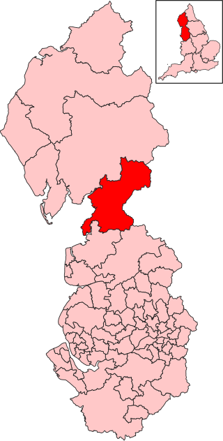
Ribble Valley is a local government district with borough status in Lancashire, England. Its council is based in Clitheroe, the largest town. The borough also includes the town of Longridge and numerous villages and surrounding rural areas. It is named after the River Ribble. Much of the district lies within the Forest of Bowland, a designated Area of Outstanding Natural Beauty.

Carnforth is a market town and civil parish in the City of Lancaster in Lancashire, England, situated at the north-east end of Morecambe Bay. The parish of Carnforth had a population of 5,560 in the 2011 census, an increase from the 5,350 recorded in the 2001 census. The town is situated around 7 miles north of Lancaster, 17 miles south of Kendal, 40 miles east of Barrow-in-Furness and 28 miles northwest of Settle. The town is also close to the Cumbria/Lancashire border.
The City of Lancaster, or simply Lancaster, is a local government district with city status in Lancashire, England. It is named after its largest settlement, Lancaster, and also includes the towns of Carnforth, Heysham and Morecambe and a wider rural hinterland. The district has a population of 144,446 (2022), and an area of 219 square miles (567 km2).
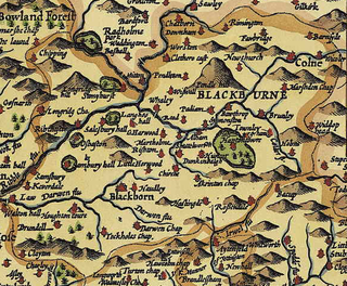
Blackburn Hundred is a historic sub-division of the county of Lancashire, in northern England. Its chief town was Blackburn, in the southwest of the hundred. It covered an area similar to modern East Lancashire, including the current districts of Ribble Valley, Pendle, Burnley, Rossendale, Hyndburn, Blackburn with Darwen, and South Ribble.
Morecambe and Lunesdale is a constituency represented in the House of Commons of the UK Parliament since the 2024 general election by Lizzi Collinge for Labour.

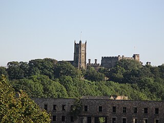
The diocese of Blackburn is diocese of the Church of England in North West England. Its boundaries correspond to northern Lancashire with the exception of the eastern part of the Forest of Bowland, which is part of the diocese of Leeds. The diocese contains 211 parishes and 280 churches. Blackburn Cathedral is the seat of the bishop of Blackburn, currently Philip North, and the diocesan offices are also located in Blackburn.

Warton is a village, civil parish and electoral ward in the Lancaster district of Lancashire, England. The village is close to the boundary with Cumbria, and approximately 1.5 miles (2.4 km) north of Carnforth, which was originally part of the parish of Warton. The village had a population of 2,315 at the 2001 census, and 2,360 at the 2011 census. The parish covers an area in excess of 11,000 acres (45 km2) and is predominantly rural.

Nether Kellet is a village and civil parish in the City of Lancaster in Lancashire, England, a few miles south of Carnforth. It had a population of 646 recorded in the 2001 census, increasing to 663 at the 2011 Census, and again to 738 at the 2021 census. The parish includes the small hamlet of Addington, to the east.

This is an as yet incomplete list of listed buildings in England, which are the majority of the listed buildings of the United Kingdom.

Lancashire is a county in North West England. In 1974 parts of the historic county were divided between Greater Manchester, Merseyside, Cheshire and Cumbria, and part of the West Riding of Yorkshire was transferred into the county, creating the non-metropolitan county of Lancashire. Together with the unitary authorities of Blackburn with Darwen and Blackpool it now forms the ceremonial county of Lancashire.

St John the Evangelist's Church is in Church Lane, Yealand Conyers, Lancashire, England. It is an active Anglican parish church in the diocese of Blackburn. The church was built in 1838, extended in 1861 and again in 1882. It is constructed mainly in limestone, and consists of a nave, a north aisle, a chancel and a west tower. Inside is a west gallery and stained glass by Shrigley and Hunt. The church holds services on Sundays and Wednesdays. It is recorded in the National Heritage List for England as a designated Grade II listed building.
Nether Wyresdale is a civil parish in the Wyre district of Lancashire, England. It contains 23 listed buildings that are recorded in the National Heritage List for England. All the listed buildings are designated at Grade II, the lowest of the three grades, which is applied to "buildings of national importance and special interest". The parish includes the villages of Scorton, the southern part of the village of Dolphinholme, and the countryside between and around them. Most of the listed buildings are houses, cottages, country houses and associated structures, and farmhouses. Also listed are a medieval cross base, a milestone, bridges, and churches and associated structures.
The Domesday Book of 1086 AD identifies King William the Conqueror's tenants-in-chief for historic Lancashire within Cestrescire (Cheshire) and Eurvicscire (Yorkshire). At the time of the Norman Conquest of England, the County of Cheshire included Inter Ripam et Mersam which became South Lancashire, while the West Riding of the County of Yorkshire included what became North Lancashire.
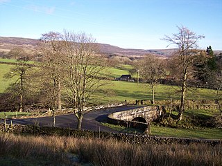
Grizedale Bridge is a Grade II listed bridge in the English parish of Over Wyresdale, Lancashire. The structure, which dates to the 19th century, carries Rakehouse Brow over the River Grizedale. A Grade II listed structure, it is in sandstone and consists of a single elliptical arch and has a solid parapet with a rounded top.


