Listed buildings in Over Kellet

Last updated

Over Kellet is a civil parish in Lancaster, Lancashire, England. It contains 35 buildings that are recorded in the National Heritage List for England as designated listed buildings. Of these, two are at Grade II*, the middle grade, and the others are at Grade II, the lowest grade. The parish contains the villages of Over Kellet and Capernwray, and is otherwise rural. Most of the listed buildings are houses, farmhouses and associated structures. The Lancaster Canal passes through the parish, and two bridges crossing it are listed. The other listed buildings include a church, a chapel, two country houses, a public house, a derelict tower, and a village cross.

Over Kellet village in the United Kingdom

Over Kellet is a village and civil parish near Carnforth in the English county of Lancashire. The parish, which is in the City of Lancaster, includes the village of Capernwray, at its northern end, and has a population of 778, decreasing slightly to 761 at the 2011 Census. The Lancaster Canal passes through the parish.

City of Lancaster City and Non-metropolitan district in England

The City of Lancaster is a local government district of Lancashire, England, with the status of a city and non-metropolitan district. It is named after its largest settlement, Lancaster, but covers a far larger area, which includes the towns of Morecambe, Heysham, and Carnforth, as well as outlying villages, farms, rural hinterland and a section of the Yorkshire Dales National Park. The district has a population of 142,500 (mid-2017 est.), and an area of 222.5 square miles (576.2 km2).

Lancashire County of England

Lancashire is a ceremonial county in North West England. The administrative centre is Preston. The county has a population of 1,449,300 and an area of 1,189 square miles (3,080 km2). People from Lancashire are known as Lancastrians.

Contents

Key

Map all coordinates using: OpenStreetMap  ·  Google Maps
Download coordinates as: KML  ·  GPX
Grade Criteria [1]
II* Particularly important buildings of more than special interest
II Buildings of national importance and special interest

Buildings

Name and locationPhotographDateNotesGrade
St Cuthbert's Church
54°07′10″N2°43′55″W / 54.11956°N 2.73184°W / 54.11956; -2.73184 (St Cuthbert's Church)
St Cuthbert's Church, Over Kellet.jpg
The oldest part of the church is in the south arcade, with most of it dating probably from the 16th century in late Perpendicular style. It was restored in 1863–64 by E. G. Paley, and again in 1909 by Austin and Paley. The church is in pebbledashed rubble with sandstone dressings, and has slate roofs. It consists of a nave, a north porch, aisles, a chancel, and a west tower with diagonal buttresses and a battlemented parapet. [2] [3]
Brookside and Brookside Cottage
54°07′25″N2°44′19″W / 54.12357°N 2.73863°W / 54.12357; -2.73863 (Brookside)
The older part is the cottage, the house being added to the left in the early 19th century. They are in sandstone, the house with a slate roof, and the cottage roof is in stone-slate. They are in two storeys, with three taller bays on the left and two on the right. The 17th-century windows are mullioned, and those from the 19th century are sashes. [4]
Old Hall Farmhouse and barn
54°07′26″N2°44′05″W / 54.12399°N 2.73459°W / 54.12399; -2.73459 (Old Hall Farmhouse)
1668The house and barn are in stone with a slate roof. The house is rendered, it has two storeys, and three bays. The windows are sashes, and on the front is a gabled porch. The doorway has a chamfered surround and a shaped lintel. The barn to the left has a wide entrance with a segmental arch. [5]
Birkland Barrow Farmhouse
54°06′53″N2°43′45″W / 54.11461°N 2.72924°W / 54.11461; -2.72924 (Birkland Barrow Farmhouse)
A sandstone house, partly rendered, with a slate roof, in two storeys with an attic. Many of the windows are mullioned; others are modern. The doorway has chamfered jambs and a shaped, inscribed lintel. [6]
Capernwray Old Hall
54°08′23″N2°43′14″W / 54.13979°N 2.72059°W / 54.13979; -2.72059 (Capernwray Old Hall)
A house in sandstone, partly pebbledashed, with a slate roof. It has a T-shaped plan, is in two storeys with an attic, and has a three-bay front. The doorway has a moulded surround and a shaped lintel. The windows are modern. [7]
Hogarth House
54°07′26″N2°44′02″W / 54.12393°N 2.73393°W / 54.12393; -2.73393 (Hogarth House)
The house dates mainly from 1759. It is in stone with a slate roof, in two storeys with an attic, and has a symmetrical two bay front. The windows on the front are double sashes with mullions. The doorway has a plain surround and a fanlight, and above it is a decorated date plaque. [8] [9]
Well House
54°07′29″N2°44′08″W / 54.12468°N 2.73567°W / 54.12468; -2.73567 (Well House)
1683The house is in pebbledashed stone with a slate roof, and has two storeys and two bays. The windows on the front are sashes, and at the rear is a mullioned window. The doorway has a moulded surround, and a battlemented lintel. [10]
Yew Tree Farmhouse
54°07′26″N2°43′49″W / 54.12398°N 2.73018°W / 54.12398; -2.73018 (Yew Tree Farmhouse)
1684A pebbledashed stone house with a slate roof in two storeys and two bays. The doorway has a moulded surround. To the left is a lower extension with a stone-slate roof, and there is an outshut at the rear. Most of the windows are mullioned. [11]
New Capernwray Farmhouse
54°08′23″N2°42′56″W / 54.13969°N 2.71548°W / 54.13969; -2.71548 (New Capernwray Farmhouse)
1687The house is in stone with a slate roof. It has a T-shaped plan, two storeys and two bays. The central doorway has chamfered jambs and a shaped lintel inscribed with initials and the date. The windows are modern. [12]
Rose Cottage
54°08′21″N2°42′58″W / 54.13930°N 2.71599°W / 54.13930; -2.71599 (Rose Cottage)
1687The cottage is in stone with a slate roof, and has two storeys and two bays. The doorway has a moulded surround, and the windows are mullioned. [13]
Croft House
54°07′24″N2°43′50″W / 54.12332°N 2.73053°W / 54.12332; -2.73053 (Croft House)
1697The house is in pebbledashed stone with a slate roof, in two storeys and three bays. The windows are sashes with plain surrounds, and the doorway has a moulded surround and a shaped inscribed lintel. There are later extensions at the rear. [14]
Hall Farmhouse
54°07′25″N2°44′21″W / 54.12358°N 2.73911°W / 54.12358; -2.73911 (Hall Farmhouse)
1704A pebbledashed stone house with a slate roof, it has two storeys with an attic. The house has a T-shaped plan with a three-bay front. The windows are sashes with plain surrounds. The doorway has a moulded surround and a shaped lintel. [15]
Greenbank Farmhouse
54°07′25″N2°44′23″W / 54.12359°N 2.73986°W / 54.12359; -2.73986 (Greenbank Farmhouse)
1712The house is in pebbledashed stone with a slate roof, and has two storeys and two bays with a rear wing. The windows are sashes, and the doorway has a chamfered surround and a battlemented lintel. In the rear wing is a mullioned window. [16]
Cragg Cottage and Cragg House
54°07′24″N2°43′49″W / 54.12334°N 2.73029°W / 54.12334; -2.73029 (Cragg Cottage and Cragg House)
1721Originally one house, later divided into two, it is in pebbledashed stone with a slate roof. There are two storeys and two bays. Most of the windows are mullioned, and one has been replaced by a horizontally-sliding sash window. The doorway has chamfered jambs and a battlemented lintel. [17]
Green Meadow
54°07′24″N2°44′24″W / 54.12346°N 2.74010°W / 54.12346; -2.74010 (Green Meadow)
1744A pebbledashed stone house with a slate roof, in two storeys with three bays, the right one skewed towards the road. There are two sash windows, the others being modern. The doorway has a moulded surround carried round an inscribed battlemented lintel. [18]
Lamond Cottage
54°07′19″N2°44′05″W / 54.12201°N 2.73460°W / 54.12201; -2.73460 (Lamond Cottage)
A sandstone house with a slate roof, in two storeys and two bays. The windows are mullioned. [19]
Wall and gate piers,
Hogarth House
54°07′26″N2°44′02″W / 54.12388°N 2.73400°W / 54.12388; -2.73400 (Wall and gate piers, Hogarth House)
The piers and wall are in sandstone. Each gate pier has chamfered rustication, a moulded cornice, and a square cap. There are low walls linking the piers to the house and to corner piers. [20]
Hogarth Cottage and barn
54°07′27″N2°44′03″W / 54.12408°N 2.73405°W / 54.12408; -2.73405 (Hogarth Cottage)
The cottage and barn are in sandstone with a slate roof. The cottage has mullioned windows and a doorway with a plain surround. The barn, to the right. has been converted for residential use, its doorway with a chamfered surround converted into a window. [21]
Kirkhouse
54°07′10″N2°43′49″W / 54.11950°N 2.73015°W / 54.11950; -2.73015 (Kirkhouse)
A pebbledashed stone house with a slate roof, in two storeys with an attic and three bays. The windows are sashes with plain surrounds. The doorway has a moulded surround and an inscribed lintel. [22] [23]
Barn, Old Hall Farm
54°07′27″N2°44′06″W / 54.12404°N 2.73513°W / 54.12404; -2.73513 (Barn, Old Hall Farm)
The barn is in sandstone with a slate roof. The wide entrance is partly blocked and has a segmental arch, and there are blocked ventilation slits. On the right gable end is a modern doorway. [24]
Kellet Lane Bridge,
(No. 130)
54°08′03″N2°44′16″W / 54.13418°N 2.73785°W / 54.13418; -2.73785 (Kellet Lane Bridge)
Kellet Lane Bridge.jpg
1797The bridge carries Kellet Lane over the Lancaster Canal. It is in sandstone and consists of a single elliptical arch with a projecting keystone and a rounded parapet. [25]
Canal bridge No 131
54°08′24″N2°43′17″W / 54.14004°N 2.72144°W / 54.14004; -2.72144 (Canal bridge No 131)
Bridge 131, Lancaster Canal - geograph.org.uk - 1659755.jpg
1797The bridge carries a lane over the Lancaster Canal. It is in sandstone and consists of a single elliptical arch with a projecting keystone and a rounded parapet. [26]
Beech House
54°07′23″N2°44′09″W / 54.12312°N 2.73573°W / 54.12312; -2.73573 (Beech House)
The house is in pebbledashed stone with a slate roof, in two storeys and three bays. The windows are sashes with plain surrounds. The doorway has a moulded surround and a lintel inscribed with the date 1679. At the rear is a mullioned window. [27]
Eagle's Head
54°07′22″N2°44′09″W / 54.12284°N 2.73575°W / 54.12284; -2.73575 (Eagle's Head)
The Eagle's Head, Over Kellet - geograph.org.uk - 866367.jpg
A public house in limestone with a slate roof. The main part has two storeys and a symmetrical three-bay front. The windows are sashes, and the door has a plain surround and a hood on consoles. A former barn and stables to the left have been incorporated into the public house. [28]
Gamekeeper's Tower
54°08′09″N2°42′14″W / 54.13594°N 2.70390°W / 54.13594; -2.70390 (Gamekeeper's Tower)
Gamekeeper's Tower - geograph.org.uk - 211124.jpg
Originating probably as a shooting lodge, it is in sandstone, and consists of a three-storey derelict tower with a turret on the north side and a battlemented parapet. On the west side is a single-storey lean-to. [29] [30]
Shenstone House and outbuildings
54°07′24″N2°44′08″W / 54.12343°N 2.73562°W / 54.12343; -2.73562 (Shenstone House)
The house and buildings are in stone with slate roofs. The house is in Georgian style, in two storeys with a basement and attic, and three bays with rear outshut. The windows are sashes and the central doorway has a moulded cornice. Associated with the house, and included in the listing are a stable, a pig sty, and a cart shed. [31]
Wilson House
54°07′27″N2°44′02″W / 54.12404°N 2.73384°W / 54.12404; -2.73384 (Wilson House)
A stone house with a slate roof, in two storeys and two bays. The openings have plain surrounds. There is a modern bay window, the other windows being sashes. [32]
Hall Garth
54°07′28″N2°44′12″W / 54.12435°N 2.73675°W / 54.12435; -2.73675 (Hall Garth)
Hall Garth, Over Kellet.jpg
1826A country house in stuccoed limestone with a hipped slate roof. It has two storeys and a main front of five bays. The windows are sashes with plain surrounds. The centre is recessed with pilasters, and a Greek Doric portico with four columns and a pediment. The west front has four bays, the north front has three, and it contains a doorway with a pediment on consoles. [2] [33]
Capernwray Chapel
54°08′39″N2°42′10″W / 54.14404°N 2.70291°W / 54.14404; -2.70291 (Capernwray Chapel)
Capernwray Evangelical Church - geograph.org.uk - 1508402.jpg
1840Originally a private chapel for Capernwray Hall by Edmund Sharpe, the tower and chancel were added by E. G. Paley in 1856. It is in sandstone with a slate roof, and consists of a nave, a chancel, and a southwest tower containing a porch. The tower has five stages with clasping buttresses, a pyramidal roof and a weathervane. The west window is in Geometrical style, and the other windows are lancets. [29] [34]
Capernwray Hall
54°08′37″N2°41′46″W / 54.14363°N 2.69624°W / 54.14363; -2.69624 (Capernwray Hall)
Capernwray Hall.jpg
1844A country house by Edmund Sharpe in Perpendicular style. It is in sandstone with a slate roof, and in two storeys with a four-storey tower. The entrance front is in nine bays and has a central two-storey porch with an oriel windows and corner turrets, and battlemented parapets. To the east is a stable court with a gateway and a tower. The windows are mullioned and transomed. [35] [36]
Old Hall and cottages
54°07′26″N2°44′00″W / 54.12377°N 2.73325°W / 54.12377; -2.73325 (Old Hall and cottages)
A house with two cottages to the right, in two storeys, with a sandstone façade and slate roofs. The windows are mullioned and there are hood moulds. The house has a symmetrical front of three bays. The windows in the lower floor are also transomed, and the doorway has a four-centred arch. The cottages are in a mirror image, and have central doorways with triangular heads. [37]
The Gables
54°07′25″N2°44′12″W / 54.12355°N 2.73665°W / 54.12355; -2.73665 (The Gables)
A sandstone house with a slate roof in two storeys. It has a west front of two bays, the left bay being gabled. The windows are mullioned, and on the left return is a gabled porch. [38]
Gates and gate piers,
Hall Garth
54°07′26″N2°44′11″W / 54.12379°N 2.73650°W / 54.12379; -2.73650 (Gates and gate piers, Hall Garth)
The gate piers are in sandstone, and are square, panelled and tapering. They have caps with a moulded cornice and a plain frieze. The gates are elaborately decorated in wrought iron, one is wide and the other is narrow, with an openwork pillar between. [39]
Village cross
54°07′26″N2°44′09″W / 54.12381°N 2.73571°W / 54.12381; -2.73571 (Village cross)
Village Cross, Over Kellet.jpg
The cross stands on the village green, and was restored in 1983. It is in sandstone and stands on two square steps. The base, which may date from the 18th century, consists of a block with a socket for the shaft. The upper part of the shaft and the head date from the restoration. [2] [40]
Walls, Hogarth House
54°07′26″N2°44′02″W / 54.12388°N 2.73382°W / 54.12388; -2.73382 (Walls, Hogarth House)
UncertainThe wall is in sandstone and it incorporates a re-set doorway. This has a chamfered surround, a triangular head, and a lintel inscribed with initials and the date 1673. [41]

Related Research Articles

Worsthorne-with-Hurstwood is a civil parish in the borough of Burnley, Lancashire, England. The parish contains 22 buildings that are recorded in the National Heritage List for England as designated listed buildings. Of these, four are listed at Grade II*, the middle grade, and the others are at Grade II, the lowest grade. Apart from the village of Worsthorne and the settlement of Hurstwood, the parish is rural. Most of the listed buildings are farmhouses, or originated as farmhouses or farm buildings. Other listed buildings include large houses and associated structures, a row of former back-to-back cottages, a church, and a telephone kiosk.

Withnell is a civil parish in the Borough of Chorley, Lancashire, England. It contains 19 buildings that are recorded in the National Heritage List for England as designated listed buildings, all of which are listed at Grade II. This grade is the lowest of the three gradings given to listed buildings and is applied to "buildings of national importance and special interest". Apart from the village of Withnell, the parish is mainly rural. Many of the listed buildings are, or originated as, farmhouses or farm buildings. The Leeds and Liverpool Canal runs through the parish, and six of the bridges crossing it are listed. The other listed buildings include cottages, large houses, and a set of stocks.

Borwick is a civil parish in Lancaster, Lancashire, England. It contains 27 listed buildings that are recorded in the National Heritage List for England. Of these, three are listed at Grade I, the top grade, and the others are at Grade II, the lowest of the three grades of listing. The parish contains the village of Borwick, and is otherwise rural. The most important building in the parish is Borwick Hall; this and a number of associated buildings and structures are listed. The Lancaster Canal passes through the parish, and associated with it are five listed bridges and an aqueduct. The other listed buildings include houses, farm buildings, bridges over the River Keer, a church, a milestone, and a telephone kiosk.

Caton-with-Littledale is a civil parish in Lancaster, Lancashire, England. It contains 53 listed buildings that are recorded in the National Heritage List for England. Of these, two are listed at Grade II*, the middle grade, and the others are at Grade II. The parish contains the villages and smaller settlements of Caton, Brookhouse, Littledale, Caton Green, and Crossgill. It is otherwise rural, with a number of isolated farms. Many of the listed buildings are houses and associated structures in the settlements and in the surrounding countryside. The other listed buildings include a church, disused chapels, a cross base, bridges, two former mills, and two milestones.

Claughton is a civil parish in Lancaster, Lancashire, England. It contains nine listed buildings that are recorded in the National Heritage List for England. Of these, one is listed at Grade I, the highest of the three grades, one is at Grade II*, the middle grade, and the others are at Grade II, the lowest grade. The parish contains the village of Claughton, and is otherwise rural. Its major structure is Claughton Hall, a country house that was moved from its original site in the village to a more isolated position in 1932–35. The hall is listed, and the other listed buildings include a former wing of the hall that is now a farmhouse, other houses, a barn, a church, a cross base in the churchyard, and a milestone.

Cockerham is a civil parish in Lancaster, Lancashire, England. It contains 19 listed buildings that are recorded in the National Heritage List for England. Of these, two are listed at Grade II*, the middle grade, and the others are at Grade II. Apart from the village of Cockerham, the parish is rural, and most of the listed buildings are houses, cottages, farmhouses and farm buildings. The other listed buildings include a church, the base of a sundial, boundary stones, and a bridge.

Halton-with-Aughton is a civil parish in Lancaster, Lancashire, England. It contains 46 listed buildings that are recorded in the National Heritage List for England. Of these, one is listed at Grade I, the highest of the three grades, three are at Grade II*, the middle grade, and the others are at Grade II, the lowest grade.

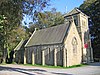
Melling-with-Wrayton is a civil parish in Lancaster, Lancashire, England. It contains 22 listed buildings that are recorded in the National Heritage List for England. Of these, one is listed at Grade I, the highest of the three grades, one is at Grade II*, the middle grade, and the others are at Grade II, the lowest grade. The parish contains the village of Melling and the hamlet of Wrayton, and is otherwise rural. Most of the listed buildings are houses, farmhouses and associated structures. The others include a church and associated structures, and two milestones.

Nether Kellet is a civil parish in Lancaster, Lancashire, England. It contains nine listed buildings that are recorded in the National Heritage List for England. All of the listed buildings are designated at Grade II, the lowest of the three grades, which is applied to "buildings of national importance and special interest". The parish contains the village of Nether Kellet, and is otherwise rural, and the listed buildings are all houses, farmhouses, or farm buildings.

Over Wyresdale is a civil parish in Lancaster, Lancashire, England. It contains 53 buildings that are recorded in the National Heritage List for England as designated listed buildings. Of these, one is at Grade II*, the middle grade, and the others are at Grade II, the lowest grade.

Quernmore is a civil parish in Lancaster, Lancashire, England. It contains 28 listed buildings that are recorded in the National Heritage List for England. Of these, one is listed at Grade I, the highest of the three grades, one is at Grade II*, the middle grade, and the others are at Grade II, the lowest grade. Apart from the small village of Quernmore, the parish is rural. Most of the listed buildings are houses, farmhouses, and associated structures. The most important house in the parish is Quernmore Park; this and associated buildings are listed. The other listed buildings include a church, a former school, an aqueduct, a former corn mill, and a former railway bridge.

Whittington is a civil parish in Lancaster, Lancashire, England. It contains 39 buildings that are recorded in the National Heritage List for England as designated listed buildings. Of these, three are at Grade II*, the middle grade, and the others are at Grade II, the lowest grade. The parish contains the villages of Whittington, Docker and Newton, and is otherwise rural. Most of the listed buildings are country houses with associated structures, smaller houses, and farm buildings. The other listed buildings include a church with a sundial in the churchyard, buildings on a model farm, three milestones, a boundary stone, and a former school.

Wray-with-Botton is a civil parish in Lancaster, Lancashire, England. It contains 44 listed buildings that are recorded in the National Heritage List for England. All of the listed buildings are designated at Grade II, the lowest of the three grades, which is applied to "buildings of national importance and special interest". The parish contains the village of Wray, and is otherwise rural containing scattered farms. Apart from a bridge, all the listed buildings are houses, farmhouses, farm buildings, and structures associated with them.

Old Laund Booth is a civil parish in Pendle, Lancashire, England. It contains 17 listed buildings that are recorded in the National Heritage List for England. All of the listed buildings are designated at Grade II, the lowest of the three grades, which is applied to "buildings of national importance and special interest". The parish contains the villages of Fence and Wheatley, and surrounding countryside. Most of the listed buildings are houses and associated structures, farmhouses and farm buildings, the others being two churches, a school, and a public house.

Roughlee Booth is a civil parish in Pendle, Lancashire, England. It contains nine listed buildings that are recorded in the National Heritage List for England. All of the listed buildings are designated at Grade II, the lowest of the three grades, which is applied to "buildings of national importance and special interest". Apart from the village of Roughlee, the parish is entirely rural. All the listed buildings are houses, farmhouses, and farm buildings.

Trawden Forest is a civil parish in Pendle, Lancashire, England. It contains 39 listed buildings that are recorded in the National Heritage List for England. Of these, six are at Grade II*, the middle grade, and the others are at Grade II, the lowest grade. The parish contains the village of Trawden and the hamlets of Cottontree, Winewall, and Wycoller, and is otherwise completely rural. Most of the listed buildings are houses and associated structures, farmhouses and farm buildings. Six bridges are listed, two clapper bridges, a packhorse bridge, two medieval or post-medieval bridges, and a 19th-century road bridge. The other listed buildings include a group of medieval stones, the ruins of a former large house, and a public house.

Great Mitton is a civil parish in Ribble Valley, Lancashire, England. It contains 17 listed buildings that are recorded in the National Heritage List for England. Of these, one is listed at Grade I, the highest of the three grades, one is at Grade II*, the middle grade, and the others are at Grade II, the lowest grade. The parish contains the village of Great Mitton and is otherwise completely rural. It is bounded by the Rivers Hodder and Ribble, and bridges crossing them are listed. The other listed buildings include houses, farmhouses, a barn, a church with associated strictures, public houses, a cross base, and a milestone.

Pendleton is a civil parish in Ribble Valley, Lancashire, England. It contains 18 listed buildings that are recorded in the National Heritage List for England. Of these, one is at Grade II*, the middle grade, and the others are at Grade II, the lowest grade. The parish contains the village of Pendleton, and is otherwise rural. All the listed buildings are houses and associated structures, or farmhouses and farm buildings, either in the village, or in the surrounding area.

Milnrow is a town in the Metropolitan Borough of Rochdale, Greater Manchester, England, and it is unparished. The town, with its suburb of Newhey and the surrounding countryside, contains 49 listed buildings that are recorded in the National Heritage List for England. Of these, three are listed at Grade II*, the middle grade, and the others are at Grade II, the lowest grade. Until the Industrial Revolution the area was rural and agricultural and most of the earlier listed buildings are houses and associated structures, farmhouses and farm buildings. When the textile industry arrived, it was initially carried out in domestic premises, and many of the listed buildings of this time are houses, often with three storeys and rows of multi-light mullioned weavers' workshop windows in the upper floors. Later came mills, one of which has survived and is listed. The other listed buildings include a public house, a bridge, churches and items in churchyards, a library and a war memorial.

References

Citations

  1. Historic England
  2. 1 2 3 Hartwell & Pevsner (2009), p. 485
  3. Historic England & 1071877
  4. Historic England & 1071869
  5. Historic England & 1317595
  6. Historic England & 1362438
  7. Historic England & 1317703
  8. Hartwell & Pevsner (2009), pp. 485–486
  9. Historic England & 1071873
  10. Historic England & 1362437
  11. Historic England & 1164868
  12. Historic England & 1362418
  13. Historic England & 1071907
  14. Historic England & 1164921
  15. Historic England & 1071870
  16. Historic England & 1362441
  17. Historic England & 1071875
  18. Historic England & 1362440
  19. Historic England & 1164987
  20. Historic England & 1164859
  21. Historic England & 1362442
  22. Hartwell & Pevsner (2009), p. 486
  23. Historic England & 1071876
  24. Historic England & 1071872
  25. Historic England & 1071867
  26. Historic England & 1164630
  27. Historic England & 1164930
  28. Historic England & 1362444
  29. 1 2 Hartwell & Pevsner (2009), p. 202
  30. Historic England & 1071866
  31. Historic England & 1396571
  32. Historic England & 1071874
  33. Historic England & 1071871
  34. Historic England & 1164650
  35. Hartwell & Pevsner (2009), pp. 201–202
  36. Historic England & 1071908
  37. Historic England & 1362443
  38. Historic England & 1362439
  39. Historic England & 1317626
  40. Historic England & 1071868
  41. Historic England & 1164831

Sources

Nikolaus Pevsner German-born British scholar

Sir Nikolaus Bernhard Leon Pevsner was a German, later British scholar of the history of art, especially of architecture.

Yale University Press university press associated with Yale University

Yale University Press is a university press associated with Yale University. It was founded in 1908 by George Parmly Day, and became an official department of Yale University in 1961, but it remains financially and operationally autonomous.

International Standard Book Number Unique numeric book identifier

The International Standard Book Number (ISBN) is a numeric commercial book identifier which is intended to be unique. Publishers purchase ISBNs from an affiliate of the International ISBN Agency.