Tockholes is a civil parish in Blackburn with Darwen, Lancashire, England. It contains 26 buildings that are recorded in the National Heritage List for England as designated listed buildings. Of these, three are listed at Grade II*, the middle grade, and the others are at Grade II, the lowest grade. Apart from the village of Tockholes, the parish is rural. The great majority of the listed buildings are farmhouses and associated farm buildings. Three of the other listed buildings are associated with the parish church, namely a sundial, a former school, and a lychgate, and the last is a structure over a well or spring in the grounds of the now-demolished Hollinshead Hall.
Cliviger is a civil parish in the borough of Burnley, Lancashire, England. The parish contains 22 listed buildings that are recorded in the National Heritage List for England. Of these, two are listed at Grade II*, the middle grade, and the others are at Grade II, the lowest grade. Apart from small settlements, the parish is rural, and most of the listed buildings are or have been farmhouses, farm buildings, and associated structures. Also in the parish are large houses, a parish church, the base of a cross, a public house, two war memorials, and two boundary stones.
Worsthorne-with-Hurstwood is a civil parish in the borough of Burnley, Lancashire, England. The parish contains 22 buildings that are recorded in the National Heritage List for England as designated listed buildings. Of these, four are listed at Grade II*, the middle grade, and the others are at Grade II, the lowest grade. Apart from the village of Worsthorne and the settlement of Hurstwood, the parish is rural. Most of the listed buildings are farmhouses, or originated as farmhouses or farm buildings. Other listed buildings include large houses and associated structures, a row of former back-to-back cottages, a church, and a telephone kiosk.
Heskin is a civil parish in the Borough of Chorley, Lancashire, England. It contains 17 buildings that are recorded in the National Heritage List for England as designated listed buildings. Of these, one is listed at Grade I, the highest of the three grades, one is at Grade II*, the middle grade, and the others are at Grade II, the lowest grade. The parish is almost completely rural, and most of the listed buildings are, or originated as, farmhouses and farm buildings. The other listed buildings are large houses and associated structures, and a cottage.
Mawdesley is a civil parish in the Borough of Chorley, Lancashire, England. It contains 18 buildings that are recorded in the National Heritage List for England as designated listed buildings. Of these, one is listed at Grade I, the highest of the three grades, one is at Grade II*, the middle grade, and the others are at Grade II, the lowest grade. The major building in the parish is Mawdesley Hall; this and two associated structure are listed. The parish contains the village of Mawdesley, but is otherwise mainly rural. Most of the listed buildings are, or originated as, farmhouses or farm buildings. The other listed buildings include other houses, cottages, a bridge, and two churches.
Burrow-with-Burrow is a civil parish in Lancaster, Lancashire, England. It contains 25 listed buildings that are recorded in the National Heritage List for England. Of these, one is listed at Grade I, the highest of the three grades, one is at Grade II*, the middle grade, and the others are at Grade II, the lowest grade. It contains a number of small settlements, including Nether Burrow, Over Burrow, Overtown and Cowan Bridge, and is otherwise rural. The major building in the parish is Burrow Hall; this country house and structures associated with it are listed. Most of the older listed buildings are domestic or agricultural, including houses and associated structures, farmhouses, and farm buildings. Later listed structures are four milestones and four boundary stones. The other listed buildings are a bridge, and inscribed stones re-set into a different bridge.
Caton-with-Littledale is a civil parish in Lancaster, Lancashire, England. It contains 53 listed buildings that are recorded in the National Heritage List for England. Of these, two are listed at Grade II*, the middle grade, and the others are at Grade II. The parish contains the villages and smaller settlements of Caton, Brookhouse, Littledale, Caton Green, and Crossgill. It is otherwise rural, with a number of isolated farms. Many of the listed buildings are houses and associated structures in the settlements and in the surrounding countryside. The other listed buildings include a church, disused chapels, a cross base, bridges, two former mills, and two milestones.
Ellel is a civil parish in Lancaster, Lancashire, England. It contains 46 listed buildings that are recorded in the National Heritage List for England. Of these, one is listed at Grade II*, the middle grade, and the others are at Grade II. The parish contains the villages of Galgate and Dolphinholme, and is otherwise rural. A high proportion of the listed buildings are country houses, smaller houses and cottages, farmhouses and farm buildings. In the 18th and 19th centuries silk spinning took place in Galgate, and two silk mills, later converted for other uses, are listed. The Lancaster Canal passes through the parish, and the junction with its Glasson Branch is also in the parish. Associated with these are listed bridges, locks, and an aqueduct. Bridges over the Rivers Wyre and Conder are also listed. Other listed buildings include a public house, churches and structures in churchyards, a milestone, a war memorial. and boundary stones.
Halton-with-Aughton is a civil parish in Lancaster, Lancashire, England. It contains 46 listed buildings that are recorded in the National Heritage List for England. Of these, one is listed at Grade I, the highest of the three grades, three are at Grade II*, the middle grade, and the others are at Grade II, the lowest grade.
Melling-with-Wrayton is a civil parish in Lancaster, Lancashire, England. It contains 22 listed buildings that are recorded in the National Heritage List for England. Of these, one is listed at Grade I, the highest of the three grades, one is at Grade II*, the middle grade, and the others are at Grade II, the lowest grade. The parish contains the village of Melling and the hamlet of Wrayton, and is otherwise rural. Most of the listed buildings are houses, farmhouses and associated structures. The others include a church and associated structures, and two milestones.
Over Wyresdale is a civil parish in Lancaster, Lancashire, England. It contains 53 buildings that are recorded in the National Heritage List for England as designated listed buildings. Of these, one is at Grade II*, the middle grade, and the others are at Grade II, the lowest grade.
Tatham is a civil parish in Lancaster, Lancashire, England. It contains 47 buildings that are recorded in the National Heritage List for England as designated listed buildings. Of these, two are at Grade II*, the middle grade, and the others are at Grade II, the lowest grade. Apart from the small settlement of Lowgill, the parish is rural, containing widespread farms. Most of the listed buildings are farmhouses, farm buildings and houses. The other listed buildings include two churches, two boundary stones, a derelict colliery engine house, a public house, and a telephone kiosk.
Whittington is a civil parish in Lancaster, Lancashire, England. It contains 39 buildings that are recorded in the National Heritage List for England as designated listed buildings. Of these, three are at Grade II*, the middle grade, and the others are at Grade II, the lowest grade. The parish contains the villages of Whittington, Docker and Newton, and is otherwise rural. Most of the listed buildings are country houses with associated structures, smaller houses, and farm buildings. The other listed buildings include a church with a sundial in the churchyard, buildings on a model farm, three milestones, a boundary stone, and a former school.
Blacko is a civil parish in Pendle, Lancashire, England. It contains twelve listed buildings that are recorded in the National Heritage List for England. All of the listed buildings are designated at Grade II, the lowest of the three grades, which is applied to "buildings of national importance and special interest". The parish contains the village of Blacko, and is otherwise rural. Most of the listed buildings are houses, farmhouses, or farm buildings. The Leeds and Liverpool Canal passes through the parish, and a bridge crossing it is listed. The other listed buildings consist of a public house, a war memorial, and a tower standing in a prominent position on a hill.
Roughlee Booth is a civil parish in Pendle, Lancashire, England. It contains nine listed buildings that are recorded in the National Heritage List for England. All of the listed buildings are designated at Grade II, the lowest of the three grades, which is applied to "buildings of national importance and special interest". Apart from the village of Roughlee, the parish is entirely rural. All the listed buildings are houses, farmhouses, and farm buildings.
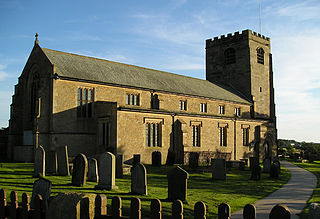
Balderstone is a civil parish in Ribble Valley, Lancashire, England. It contains five listed buildings that are recorded in the National Heritage List for England. All of the listed buildings are designated at Grade II, the lowest of the three grades, which is applied to "buildings of national importance and special interest". The parish contains the village of Balderstone, and is otherwise rural. The listed buildings consist of two farmhouses, a farm building, a church, and a sundial in the churchyard.
Downham is a civil parish in Ribble Valley, Lancashire, England. It contains 43 listed buildings that are recorded in the National Heritage List for England. Of these, three are at Grade II*, the middle grade, and the others are at Grade II, the lowest grade. The parish contains the village of Downham and surrounding countryside. Most of the listed buildings are in the village, and include Downham Hall and associated structures, houses and cottages, a church, a public house, a school, milestones, a bridge, and a set of stocks. Outside the village the listed buildings are farmhouses and farm buildings.
Samlesbury is a civil parish in the South Ribble district of Lancashire, England. It contains 22 listed buildings that are recorded in the National Heritage List for England. Of these, two are listed at Grade I, the highest of the three grades, and the others are at Grade II, the lowest grade. The parish is mainly rural, and many of its listed buildings are houses, farmhouses and farm buildings. The most important buildings are Samlesbury Hall and the parish church, both of which are listed at Grade I. The other listed buildings include structures associated with the church, a school, a bridge, a church built in the 19th century, and a lodge to the hall.
Walton-le-Dale is a large village in the South Ribble district of Lancashire, England. In the area close to it are the settlements of Higher Walton, Walton Summit, Bamber Bridge, and Gregson Lane. This area contains 34 buildings that are recorded in the National Heritage List for England as designated listed buildings. Of these, six are listed at Grade II*, the middle grade, and the others are at Grade II, the lowest grade. The area is partly residential and partly rural. Its listed buildings include churches and associated structures, houses, farmhouses and farm buildings, public houses, and a war memorial.
Forton is a civil parish in the Wyre district of Lancashire, England. It contains 25 listed buildings that are recorded in the National Heritage List for England. All the listed buildings are designated at Grade II, the lowest of the three grades, which is applied to "buildings of national importance and special interest". The parish contains the village of Forton, and is otherwise mainly rural. The Lancaster Canal passes through the parish, and two bridges crossing it are listed. Also passing through the parish is the M6 motorway, and tower and former restaurant at Lancaster (Forton) Services are listed. The other listed buildings include houses and cottages, farmhouses and farm buildings, churches and associated structures, a medieval cross base, milestones, boundary stones, a war memorial, and a former school.