
An Taibhdhearc is the national Irish language theatre of Ireland. It was founded in 1928.
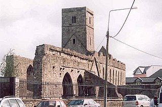
Sligo Abbey, a ruined abbey in Sligo, Ireland, was originally built in 1253 by the order of Maurice Fitzgerald, Baron of Offaly. It was destroyed in 1414 by a fire, ravaged during the Nine Years' War in 1595 and once more in 1641 during the Ulster Uprising. The friars moved out in the 18th century, but Lord Palmerston restored the Abbey in the 1850s. Currently, it is open to the public.
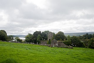
Ballindoon Friary was a Dominican monastery beside Lough Arrow in County Sligo, Ireland. It was dedicated to St. Mary and founded in 1507 by Thomas O'Farrell. It was dissolved c. 1585 and is now in ruins.

Rosserk Friary is a friary located in County Mayo, Ireland and a National Monument.located along the river moy the friary was set up by the third order of Franciscans
Nysted Friary, located in Nysted, on the island of Lolland in southern Denmark, now in Guldborgsund municipality in Region Sjælland, was the last occupied Franciscan friary in Denmark after the Reformation.
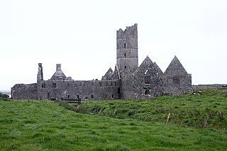
Moyne Abbey is one of the most impressive ecclesiastical ruins in Mayo and a National Monument. It was founded before the year (1455) by the Burke family as a Franciscan friary and consecrated in 1462. It is located north of Ballina on the west side of Killala Bay. Like its neighbour, Rosserk Friary, it was burnt by Sir Richard Bingham, Elizabeth I of England's governor of Connacht, in 1590 in reformationist zeal.
The Franciscan Friary of Southampton was founded c. 1233. It occupied a south-eastern area of the city, within the walls and adjacent to God's House Tower. The friary was notable for its water supply system, which supplied water for use by the friars themselves and by the other inhabitants of Southampton. The friary was dissolved in 1538 and the last remains were swept away in the 1940s. The site is now occupied by Friary House. Elsewhere, remnants of the extensive water supply system still survive today.
South Staffordshire College is a further education college located over four sites in Staffordshire, England.

Whitefriars was a Carmelite friary on the lower slopes of St Michael's Hill, Bristol, England. It was established in 1267; in subsequent centuries a friary church was built and extensive gardens developed. The establishment was dissolved in 1538.
Appleby Friary was a friary in Cumbria, England.
Carlisle Dominican Friary was a friary in Cumbria, England.
Carlisle Franciscan Friary was a medieval monastic house in Cumbria, England.
Penrith Friary was an Augustinian friary in Cumbria, England.
Whitefriars, also known as White Friers or The College of Carmelites, Gloucester, England, was a Carmelite friary of which nothing now survives.
Preston Friary was a friary in Lancashire, England.

Greyfriars, Stamford was a Franciscan friary in Lincolnshire, England. It was one of several religious houses in Stamford suppressed in the Dissolution of the Monasteries.

Boston Friary refers to any one of four friaries that existed in Boston, Lincolnshire, England.

Greyfriars, Richmond was a friary in North Yorkshire, England.
Carmelite Friary, Newcastle-upon-Tyne was a friary in Tyne and Wear, England.
Tickhill Friary was an Augustinian friary in Tickhill, South Yorkshire, England. John Clarel, a canon of Southwell, founded it about 1260. It was dissolved in 1530. The remains are a Grade II* listed monument. The 14th century buildings were converted into dwellings in the 17th century, extensions followed in the 19th century. Until 1538, the Fitzwilliam tomb was located in the friary church, but was then moved into the parish church.


