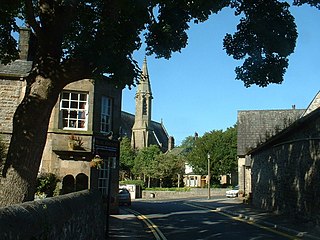
Carnforth is a market town and civil parish in the City of Lancaster in Lancashire, England, situated at the north-east end of Morecambe Bay. The parish of Carnforth had a population of 5,560 in the 2011 census, an increase from the 5,350 recorded in the 2001 census. The town is situated around 7 miles north of Lancaster, 17 miles south of Kendal, 40 miles east of Barrow-in-Furness and 28 miles north-west of Settle. The town is also close to the Cumbria/Lancashire border.
The City of Lancaster, or simply Lancaster, is a local government district with city status in Lancashire, England. It is named after its largest settlement, Lancaster, and also includes the towns of Carnforth, Heysham and Morecambe and a wider rural hinterland. The district has a population of 144,446 (2022), and an area of 219 square miles (567 km2).
Bolton-le-Sands is a large village and civil parish of the City of Lancaster in Lancashire, England. The parish had a population of 4,098 recorded in the 2001 census, increasing to 4,127 at the 2011 Census.

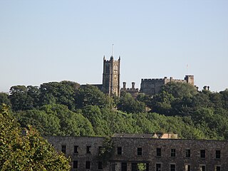
Capernwray Hall is a former country house situated 3 miles east-northeast of Carnforth, Lancashire, England, and is currently used as a Christian Bible school and holiday centre. The house is recorded in the National Heritage List for England as a designated Grade II* listed building. It stands in grounds included in the Register of Historic Parks and Gardens at Grade II.

Silverdale is a village and civil parish within the City of Lancaster district of Lancashire, England. The village stands on Morecambe Bay, near the border with Cumbria, 4.5 miles (7 km) north west of Carnforth and 8.5 miles (14 km) of Lancaster. The parish had a population of 1,519 recorded in the 2011 census.

Beetham is a village and civil parish in Westmorland and Furness, Cumbria, England. It is situated on the border with Lancashire, 6 miles (10 km) north of Carnforth. It is part of the Arnside and Silverdale Area of Outstanding Natural Beauty. In the 2001 census the parish had a population of 1,724, increasing at the 2011 census to 1,784.

Yealand Redmayne is a village in the civil parish of The Yealands, in the Lancaster district, in the county of Lancashire, England. In 2011 the former parish of Yealand Redmayne had a population of 326.

Chipping is a village and civil parish in the borough of Ribble Valley, Lancashire, England, within the Forest of Bowland Area of Outstanding Natural Beauty. Its grid reference is SD6243, and the nearest substantial settlement is Longridge, nearly 4 mi (6.4 km) to the south. In the 2001 census, the parish had a population of 1,046, falling slightly to 1,043 at the 2011 census. The village has won several best-kept village competitions over the years. The village also won the village section of the Royal Horticultural Society Britain in Bloom competition in 2009, picking up RHS Tourism and Gold achievement awards in the process.

Staining is a village and civil parish in Lancashire, England, on the Fylde coast close to the seaside resorts of Blackpool and Lytham St Annes, and the market town of Poulton-le-Fylde. At the 2011 Census, it had a population of 2,290. Historically, the village was part of the township of Hardhorn-with-Newton. Now the hamlet of Newton is part of the civil parish of Staining; Hardhorn belongs to Poulton-le-Fylde.

Nether Kellet is a village and civil parish in the City of Lancaster in Lancashire, England, a few miles south of Carnforth. It had a population of 646 recorded in the 2001 census, increasing to 663 at the 2011 Census, and again to 738 at the 2021 census. The parish includes the small hamlet of Addington, to the east.

Osbaldeston is a village and civil parish in Lancashire, England about 3+1⁄4 miles (5.2 km) north-west of Blackburn and 7 miles (11.3 km) east of Preston. The population of the civil parish as taken at the 2011 census was 185.
Capernwray Chapel is in the village of Capernwray, Over Kellet, Lancashire, England. Formerly the chapel to Capernwray Hall, it is now an independent Evangelical chapel. It is recorded in the National Heritage List for England as a designated Grade II listed building.

St Mary's Church is in the village of Yealand Conyers, Lancashire, England. It is an active Roman Catholic church in the diocese of Lancaster, and is linked with the churches of St Mary of the Angels, Bolton-le-Sands, and Our Lady of Lourdes, Carnforth. The church is recorded in the National Heritage List for England as a designated Grade II listed building. It stands at the south end of the village.

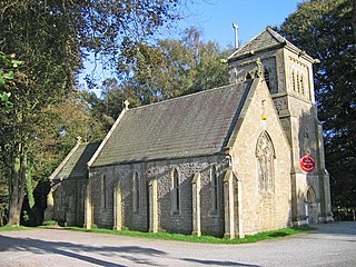
St Cuthbert's Church is in the village of Over Kellet, Lancashire, England. It is an active Anglican parish church in the deanery of Tunstall, the archdeaconry of Lancaster, and the diocese of Blackburn. The church is recorded in the National Heritage List for England as a designated Grade II* listed building.

St Luke's Church is in the village of Winmarleigh, Lancashire, England. It is an active Church of England parish church in the Diocese of Blackburn, the archdeaconry of Lancaster, and the deanery of Lancaster and Morecambe. The church was built in 1875–1876 by Paley and Austin, and is recorded in the National Heritage List for England as a designated Grade II listed building.

Euxton Parish Church is in the English village of Euxton in the borough of Chorley, Lancashire. It is an active parish church in the Diocese of Blackburn and the archdeaconry of Blackburn. It is recorded in the National Heritage List for England as a designated Grade II* listed building. The church has a seating capacity of 191.
Borwick is a civil parish in Lancaster, Lancashire, England. It contains 27 listed buildings that are recorded in the National Heritage List for England. Of these, three are listed at Grade I, the top grade, and the others are at Grade II, the lowest of the three grades of listing. The parish contains the village of Borwick, and is otherwise rural. The most important building in the parish is Borwick Hall; this and a number of associated buildings and structures are listed. The Lancaster Canal passes through the parish, and associated with it are five listed bridges and an aqueduct. The other listed buildings include houses, farm buildings, bridges over the River Keer, a church, a milestone, and a telephone kiosk.
Carnforth is a civil parish in Lancaster, Lancashire, England. It contains 20 listed buildings that are recorded in the National Heritage List for England. Of these, three are at Grade II*, the middle grade, and the others are at Grade II, the lowest grade. Until the coming of the railway in the middle of the 19th century the parish contained what was then the village of Carnforth, and was otherwise rural. By the later part of the century it had become an important railway junction, linking the south of England with Carlisle, Barrow-in-Furness, and Leeds. There are seven listed buildings associated with the railway and, in addition, a signal box moved from another site. The Lancaster Canal passes through the parish, and two bridges crossing it are listed. The other listed buildings include houses, a farmhouse, a farm building, a public house, a church, and a milestone.
Nether Kellet is a civil parish in Lancaster, Lancashire, England. It contains nine listed buildings that are recorded in the National Heritage List for England. All of the listed buildings are designated at Grade II, the lowest of the three grades, which is applied to "buildings of national importance and special interest". The parish contains the village of Nether Kellet, and is otherwise rural, and the listed buildings are all houses, farmhouses, or farm buildings.
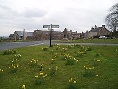
Over Kellet is a civil parish in Lancaster, Lancashire, England. It contains 35 buildings that are recorded in the National Heritage List for England as designated listed buildings. Of these, two are at Grade II*, the middle grade, and the others are at Grade II, the lowest grade. The parish contains the villages of Over Kellet and Capernwray, and is otherwise rural. Most of the listed buildings are houses, farmhouses and associated structures. The Lancaster Canal passes through the parish, and two bridges crossing it are listed. The other listed buildings include a church, a chapel, two country houses, a public house, a derelict tower, and a village cross.