
Lancaster is a city in Lancashire, England, and the main cultural hub, economic and commercial centre of City of Lancaster district. The city is on the River Lune, directly inland from Morecambe Bay. Lancaster is the county town, although Lancashire County Council has been based at County Hall in Preston since its formation in 1889.
The City of Lancaster, or simply Lancaster, is a local government district with city status in Lancashire, England. It is named after its largest settlement, Lancaster, and also includes the towns of Carnforth, Heysham and Morecambe and a wider rural hinterland. The district has a population of 144,446 (2022), and an area of 219 square miles (567 km2).

The River Lune is a river 53 miles (85 km) in length in Cumbria and Lancashire, England.

Melling-with-Wrayton is a civil parish in the City of Lancaster in the English county of Lancashire. It includes the village of Melling and the hamlet of Wrayton, to the northeast. The parish had a population of 290 recorded in the 2001 census, increasing slightly to 299 at the 2011 census.

Halton-with-Aughton is a civil parish and electoral ward located 3 miles (5 km) east of Lancaster, England, on the north bank of the River Lune. The main settlement is the village of Halton, or Halton-on-Lune, in the west, and the parish stretches to the hamlet of Aughton in the east. It lies in the City of Lancaster district of Lancashire, and has a population of 2,227, down from 2,360 in 2001.

Arkholme-with-Cawood is a civil parish of the City of Lancaster in Lancashire, England. The parish of Arkholme-with-Cawood had a population of 334 recorded in the 2001 census, falling marginally to 333 at the 2011 Census. The parish is north east of Lancaster and lies on the B6254 road.
Burrow-with-Burrow is a civil parish in the English county of Lancashire. The parish of Burrow-with-Burrow had a population of 191 recorded in the 2001 census, decreasing to 182 at the 2011 Census.

Wray is a small village in Lancashire, England, part of the civil parish of Wray-with-Botton, in the City of Lancaster district. Wray is the point at which the River Roeburn joins the River Hindburn.
The civil parish of Caton-with-Littledale is situated in Lancashire, England, near the River Lune. The parish lies within the Forest of Bowland Area of Outstanding Natural Beauty and contains the villages of Caton, Brookhouse, Caton Green, Littledale and Townend.

Newsholme is a small village and civil parish in the Ribble Valley, Lancashire, England, but lies within the historic West Riding of Yorkshire. According to the 2001 census, the parish had a population of 50, however the United Kingdom Census 2011 grouped the parish with Horton and Paythorne, giving a total of 253. Today it lies near the boundary with North Yorkshire on the A682, 4 miles (6 km) north of Barnoldswick and 12 miles (19 km) west of Skipton.

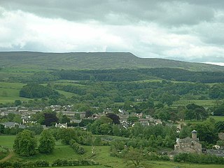
Downham is a village and civil parish in Lancashire, England. It is in the Ribble Valley district and at the United Kingdom 2001 census had a population of 156. The 2011 Census includes neighbouring Twiston giving a total for both parishes of 214. The village is on the north side of Pendle Hill off the A59 road about 3 miles (4.8 km) from Clitheroe. Much of the parish, including the village is part of the Forest of Bowland Area of Outstanding Natural Beauty (AONB). It adjoins the Ribble Valley parishes of Rimington, Twiston, Worston, Chatburn and Sawley, and the Pendle parish of Barley-with-Wheatley Booth.

Claughton is a small village and civil parish in the City of Lancaster in Lancashire, England. The village is on the A683 road east of Lancaster and at the time of the 2001 census had a population of 132. In the 2011 census Claughton was grouped with Roeburndale to give a total of 223.

Thurnham is a civil parish in Lancashire, England. It is situated on the south side of the River Lune estuary in the City of Lancaster, and contains the villages of Conder Green, Glasson Dock, Lower Thurnham and Upper Thurnham. The parish has a population of 595, increasing to 651 at the 2011 census.

Hornby-with-Farleton is a civil parish in the City of Lancaster in Lancashire, England. It had a population of 729 recorded in the 2001 census, increasing marginally to 730 at the 2011 census. The parish is about 8.5 miles (13.7 km) north-east of Lancaster and consists of two villages: Hornby and Farleton, both on the A683 road. The parish was formed 24 March 1887 from the parishes of "Hornby" and "Farleton".

St Michael's Church is located in the settlement of Whittington, Lancashire, England. It is an active Anglican parish church in the deanery of Tunstall, the archdeaconry of Lancaster and the diocese of Blackburn. Its benefice is united with those of St John the Evangelist, Gressingham, St Margaret, Hornby, and St John the Baptist, Arkholme. The church is recorded in the National Heritage List for England as a designated Grade II* listed building.

St John the Baptist's Church, is in the village of Arkholme, Lancaster, Lancashire, England. It is an active Anglican parish church in the deanery of Tunstall, the archdeaconry of Lancaster, and the diocese of Blackburn. Its benefice is united with those of St Margaret, Hornby, St John the Evangelist, Gressingham, and St Michael the Archangel, Whittington-in-Lonsdale. The church is recorded in the National Heritage List for England as a designated Grade II* listed building. It stands at the end of the village street, overlooking the River Lune, within the bailey of a former castle. The former 11th-century motte stands to the northeast of the church.
Whittington is a civil parish in Lancaster, Lancashire, England. It contains 39 buildings that are recorded in the National Heritage List for England as designated listed buildings. Of these, three are at Grade II*, the middle grade, and the others are at Grade II, the lowest grade. The parish contains the villages of Whittington, Docker and Newton, and is otherwise rural. Most of the listed buildings are country houses with associated structures, smaller houses, and farm buildings. The other listed buildings include a church with a sundial in the churchyard, buildings on a model farm, three milestones, a boundary stone, and a former school.

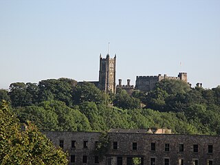
Hornby is a village and former civil parish located 9 miles (14 km) from Lancaster, now part of the parish of Hornby-with-Farleton, within the Lancaster district of the county of Lancashire, England. Situated on the A683 the village lies at the confluence of the River Wenning and Lune In 2011 the built up area had a population of 468. In 1881, the parish had a population of 358.

The Crook o' Lune or Crook of Lune, about 3 mi (4.8 km) north-east of Lancaster, Lancashire, is a horseshoe bend of the River Lune, which here meanders through meadows and low hills into a wooded gorge. It has long been noted for its views eastward up the Lune valley to Hornby Castle and, in the far distance, Ingleborough and other Pennine fells. It was painted by J. M. W. Turner and its scenic attractions were celebrated by such writers as Thomas Gray and William Wordsworth. In recent years the Sunday Times has claimed that it "rivals the beauty of the Lake District". It lies within the Forest of Bowland Area of Outstanding Natural Beauty and the Lune Millennium Park. The river is crossed here by two former railway viaducts and one road bridge, all being Grade II listed buildings.

Newton is a hamlet in the civil parish of Whittington, Lancashire, England. It is in the City of Lancaster district, south of Whittington on the B 6254 road and about half a mile west of the River Lune.


