Heaton-with-Oxcliffe

Last updated

Heaton-with-Oxcliffe
Duck Pond, Cathedral Drive, Morecambe, North Lancs. - geograph.org.uk - 55987.jpg
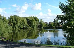
Duck pond at Cathedral Drive
Location map United Kingdom City of Lancaster.svg
Red pog.svg
Heaton-with-Oxcliffe
Location in the City of Lancaster district
Lancashire UK location map.svg
Red pog.svg
Heaton-with-Oxcliffe
Location within Lancashire
Population2,059 (2001)
OS grid reference SD443603
Civil parish
  • Heaton-with-Oxcliffe
District
Shire county
Region
Country England
Sovereign state United Kingdom
Post town MORECAMBE
Postcode district LA3
Dialling code 01524
Police Lancashire
Fire Lancashire
Ambulance North West
UK Parliament
List of places
UK
England
Lancashire
54°02′10″N2°51′00″W / 54.036°N 2.850°W / 54.036; -2.850 Coordinates: 54°02′10″N2°51′00″W / 54.036°N 2.850°W / 54.036; -2.850

Heaton-with-Oxcliffe is a civil parish situated near the River Lune. it is in the City of Lancaster and the English county of Lancashire. The parish contains the villages of Heaton, Oxcliffe Hill, plus the area around Salt Ayre, and had a population of 2,225 recorded in the 2001 census, [1] decreasing to 2,059 at the 2011 census. [2]

Contents

The Golden Ball Inn

The area around the Golden Ball Inn, in Oxcliffe, is locally known as Snatchems, as it was once a place that press gangs frequented. The front door of the Inn is 6 feet (1.8 m) above the road, as the road frequently floods on a spring tide, the lower car park displaying a white line on the wall, about 5 feet (1.5 m) above the ground, showing the highest level that the Lune reached during a major flood in 1967.

Notable people

See also

Related Research Articles

<span class="mw-page-title-main">Kirkby Lonsdale</span> Town in the southern Lakelands of Cumbria, England

Kirkby Lonsdale is a town and civil parish in the South Lakeland district of Cumbria, England, on the River Lune. Historically in Westmorland, it lies 13 miles (21 km) south-east of Kendal on the A65. The parish recorded a population of 1,771 in the 2001 census, increasing to 1,843 at the 2011 Census.

<span class="mw-page-title-main">River Lune</span> River in Cumbria and Lancashire, England

The River Lune is a river 53 miles (85 km) in length in Cumbria and Lancashire, England.

Heaton Norris is a suburb of the Metropolitan Borough of Stockport, Greater Manchester, England. It is part of the Four Heatons, and neighbours Heaton Chapel, Heaton Mersey and Heaton Moor. Within the boundaries of the historic county of Lancashire, in 1835 part of Heaton Norris was annexed to the County Borough of Stockport, with Heaton Chapel and Heaton Moor following in 1894 and the remnant in 1913.

<span class="mw-page-title-main">Prestwich</span> Town in Greater Manchester

Prestwich is a town in the Metropolitan Borough of Bury, Greater Manchester, England, 3.3 miles (5.3 km) north of Manchester city centre, 3.1 miles (5 km) north of Salford and 4.7 miles (7.6 km) south of Bury.

<span class="mw-page-title-main">Melling-with-Wrayton</span> Civil parish in the City of Lancaster, Lancashire, England

Melling-with-Wrayton is a civil parish in the City of Lancaster in the English county of Lancashire. It includes the village of Melling and the hamlet of Wrayton, to the northeast. The parish had a population of 290 recorded in the 2001 census, increasing slightly to 299 at the 2011 census.

<span class="mw-page-title-main">Cockerham</span> Village in Lancashire, England

Cockerham is a small village and civil parish within the City of Lancaster district in Lancashire, England. It is 6 miles (9.7 km) south of Lancaster and 15 miles (24 km) north-northwest of Preston. Lying on the River Cocker, at the estuary of the River Lune, the parish had a population of 671 at the 2011 Census.

<span class="mw-page-title-main">Halton-with-Aughton</span> Human settlement in England

Halton-with-Aughton is a civil parish and electoral ward located 3 miles (5 km) east of Lancaster, England, on the north bank of the River Lune. The main settlement is the village of Halton, or Halton-on-Lune, in the west, and the parish stretches to the hamlet of Aughton in the east. It lies in the City of Lancaster district of Lancashire, and has a population of 2,227, down from 2,360 in 2001.

<span class="mw-page-title-main">Abram, Greater Manchester</span> Human settlement in England

Abram is a village and electoral ward in the Metropolitan Borough of Wigan, Greater Manchester, England. It lies on flat land on the northeast bank of the Leeds and Liverpool Canal, 2 miles (3.2 km) west of Leigh, 3 miles (4.8 km) southeast of Wigan, and 14.5 miles (23 km) west of Manchester. Abram is a dormitory village with a population of 9,855.

<span class="mw-page-title-main">Rufford, Lancashire</span> Village in West Lancashire, England

Rufford is a village in West Lancashire, England, where the Leeds and Liverpool Canal, Liverpool, Ormskirk and Preston Railway, the A59 and the River Douglas meet.

<span class="mw-page-title-main">Rishton</span> Human settlement in England

Rishton is a town in the Hyndburn district of Lancashire, England, about 2 miles (3 km) west of Clayton-le-Moors and 4 miles (6 km) north east of Blackburn. It was an urban district from about 1894 to 1974. The population at the census of 2011 was 6,625.

<span class="mw-page-title-main">Lostock, Bolton</span> Human settlement in England

Lostock is a residential district of Bolton, Greater Manchester, England, 3.5 miles (5.6 km) west of Bolton town centre and 13 miles (21 km) northwest of Manchester. Historically part of Lancashire, Lostock is bounded by Deane to the southeast, Markland Hill to the northeast, and Middlebrook to the west. Bolton Wanderers' football ground, the University of Bolton Stadium, is in nearby Horwich.

<span class="mw-page-title-main">Cliviger</span> Human settlement in England

Cliviger is a civil parish in the Borough of Burnley, in Lancashire, England. It is situated to the southeast of Burnley, and northwest of Todmorden. According to the 2011 census, the parish has a population of 2,238.

<span class="mw-page-title-main">Caton-with-Littledale</span> Human settlement in England

The civil parish of Caton-with-Littledale is situated in Lancashire, England, near the River Lune. The parish lies within the Forest of Bowland Area of Outstanding Natural Beauty and contains the villages of Caton, Brookhouse, Caton Green, Littledale and Townend.

Kislingbury is a village in Northamptonshire, England, about 4 miles (6 km) west of Northampton town centre, and close to junctions 15A and 16 of the M1 motorway.

<span class="mw-page-title-main">Sabden</span> Human settlement in England

Sabden is a village and civil parish in the Ribble Valley, Lancashire, England. Sabden is located south of Pendle Hill, in a valley about three miles north west of Padiham. The parish covers 2,450.9 acres (991.85 ha), of which 103.2 acres (41.75 ha) is occupied by the village. It lies in the Forest of Pendle section of the Forest of Bowland Area of Outstanding Natural Beauty.

<span class="mw-page-title-main">Hapton, Lancashire</span> Human settlement in England

Hapton is a village and civil parish in the Borough of Burnley in Lancashire, England, 3 miles (4.8 km) west of Burnley, with a railway station on the East Lancashire Line. At the United Kingdom Census 2011, it had a population of 1,979.

<span class="mw-page-title-main">Westby-with-Plumptons</span> Human settlement in England

Westby-with-Plumptons is a civil parish in Lancashire, England. The parish is in Fylde district and contains the hamlets of Great Plumpton, Little Plumpton, Lower Ballam, Higher Ballam, Moss Side, Peel, and Westby. At the 2011 census, the parish had a population of 1,205. Westby and Plumpton are mentioned in the Domesday Book, as "Westbi" and "Pluntun".

<span class="mw-page-title-main">Claughton, Lancaster</span> Village and parish in Lancashire, England

Claughton is a small village and civil parish in the City of Lancaster in Lancashire, England. The village is on the A683 road east of Lancaster and at the time of the 2001 census had a population of 132. In the 2011 census Claughton was grouped with Roeburndale to give a total of 223.

<span class="mw-page-title-main">Hornby-with-Farleton</span> Human settlement in England

Hornby-with-Farleton is a civil parish in the City of Lancaster in Lancashire, England. It had a population of 729 recorded in the 2001 census, increasing marginally to 730 at the 2011 census. The parish is about 8.5 miles (13.7 km) north-east of Lancaster and consists of two villages: Hornby and Farleton, both on the A683 road. The parish was formed 24 March 1887 from the parishes of "Hornby" and "Farleton".

Mary Ann Bibby was a New Zealand storekeeper. She was born in Heaton, Lancashire, England. She managed a successful import firm from 1862 onward and became known as one of the first successful businesswomen of the colony.

References

  1. "Parish headcount" (PDF). Lancashire County Council. Archived from the original (PDF) on 10 December 2006. Retrieved 10 January 2009.
  2. UK Census (2011). "Local Area Report – Heaton-with-Oxcliffe Parish (E04005190)". Nomis. Office for National Statistics . Retrieved 27 March 2021.
  3. Gray, Margaret A. "Mary Ann Bibby". Dictionary of New Zealand Biography . Ministry for Culture and Heritage . Retrieved 23 April 2017.

Commons-logo.svg Media related to Heaton-with-Oxcliffe at Wikimedia Commons