The City of Lancaster, or simply Lancaster, is a local government district with city status in Lancashire, England. It is named after its largest settlement, Lancaster, and also includes the towns of Carnforth, Heysham and Morecambe and a wider rural hinterland. The district has a population of 144,446 (2022), and an area of 219 square miles (567 km2).
The North Western Railway (NWR) was an early British railway company in the north-west of England. It was commonly known as the "Little" North Western Railway, to distinguish it from the larger London and North Western Railway (LNWR).

Halton-with-Aughton is a civil parish and electoral ward located 3 miles (5 km) east of Lancaster, England, on the north bank of the River Lune. The main settlement is the village of Halton, or Halton-on-Lune, in the west, and the parish stretches to the hamlet of Aughton in the east. It lies in the City of Lancaster district of Lancashire, and has a population of 2,227, down from 2,360 in 2001.

Wennington is a civil parish in the City of Lancaster district in Lancashire, England. The 2001 Census recorded the parish's population as 102, and the 2011 Census recorded it as 178.

The Furness and Midland Joint Railway was a joint railway in England owned by the Furness Railway and the Midland Railway. Construction was agreed in 1862 for a line from Carnforth, on the Furness system, to Wennington, on the Midland Railway line from Yorkshire to Morecambe. Royal assent was received in June 1863 and the contract for the route was let to Benton & Woodiwiss soon after at a cost of some £102,850.

Tebay is a village and civil parish in Cumbria, England, within the historic borders of Westmorland. It lies in the upper Lune Valley, at the head of the Lune Gorge. The parish had a population of 728 in the 2001 census, increasing to 776 at the Census 2011.

Arkholme-with-Cawood is a civil parish of the City of Lancaster in Lancashire, England. The parish of Arkholme-with-Cawood had a population of 334 recorded in the 2001 census, falling marginally to 333 at the 2011 Census. The parish is north east of Lancaster and lies on the B6254 road.

Whittington is a small village and civil parish in Lancashire, England, forming part of a cluster of sites along the Lune valley, each with evidence of a motte - as with Melling and Arkholme. This is the densest distribution of Norman castles outside the Welsh border countryside.
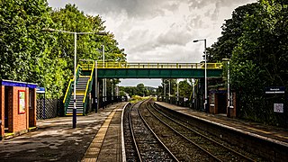
Wennington is a railway station on the Bentham Line, which runs between Leeds and Morecambe via Skipton. The station, situated 15+3⁄4 miles (25 km) east of Lancaster, serves the village of Wennington in Lancashire. It is owned by Network Rail and managed by Northern Trains.
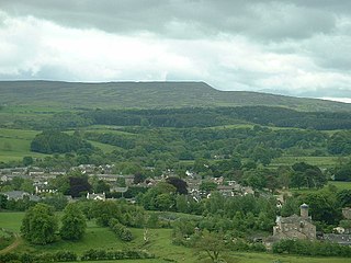
The civil parish of Caton-with-Littledale is situated in Lancashire, England, near the River Lune. The parish lies within the Forest of Bowland Area of Outstanding Natural Beauty and contains the villages of Caton, Brookhouse, Caton Green, Littledale and Townend.

St Wilfrid's Church is in Main Street, Melling, Lancashire, England. It is recorded in the National Heritage List for England as a designated Grade I listed building, and is an active Anglican church in the united benefice of East Lonsdale, the deanery of Tunstall, the archdeaconry of Lancaster and the diocese of Blackburn. Its benefice is combined with those of St Peter, Leck, St John the Baptist, Tunstall, St James the Less, Tatham, the Good Shepherd, Lowgill, and Holy Trinity, Wray.

Claughton is a small village and civil parish in the City of Lancaster in Lancashire, England. The village is on the A683 road east of Lancaster and at the time of the 2001 census had a population of 132. In the 2011 census Claughton was grouped with Roeburndale to give a total of 223.

Lancaster Green Ayre railway station was the Midland Railway's station in the city of Lancaster in England. The line between Green Ayre and Morecambe was used for pioneering experimental electrification via overhead wires.

The Leeds–Morecambe line, also known as the Bentham line, is a railway line running between Leeds, Skipton, Lancaster and Morecambe in northern England. The service is operated by Northern. The route covered by the service was historically part of the Midland Railway. The line is electrified at 25 kV AC overhead between Leeds City and Skipton- this section is known as the Airedale line.

Arkholme for Kirkby Lonsdale railway station served the village of Arkholme in Lancashire, England. It is situated on what is now the Leeds–Morecambe line between the current Wennington and Carnforth stations.

St John the Baptist's Church, is in the village of Arkholme, Lancaster, Lancashire, England. It is an active Anglican parish church in the deanery of Tunstall, the archdeaconry of Lancaster, and the diocese of Blackburn. Its benefice is united with those of St Margaret, Hornby, St John the Evangelist, Gressingham, and St Michael the Archangel, Whittington-in-Lonsdale. The church is recorded in the National Heritage List for England as a designated Grade II* listed building. It stands at the end of the village street, overlooking the River Lune, within the bailey of a former castle. The former 11th-century motte stands to the northeast of the church.

Borwick railway station formerly served the village of Borwick in Lancashire, England. It was located on the Furness and Midland Joint Railway line between Carnforth and Wennington, 3 miles (5 km) east of Carnforth Joint station.

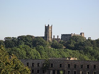
Hornby is a village and former civil parish located 9 miles (14 km) from Lancaster, now part of the parish of Hornby-with-Farleton, within the Lancaster district of the county of Lancashire, England. Situated on the A683 the village lies at the confluence of the River Wenning and Lune In 2011 the built up area had a population of 468. In 1881, the parish had a population of 358.
Caton railway station served the village of Caton in the City of Lancaster district of Lancashire, England.
Melling railway station served the village of Melling, Lancashire, England, from 1867 to 1952 on the Furness and Midland Joint Railway.


