
Lancashire is a ceremonial county in North West England. It is bordered by Cumbria to the north, North Yorkshire and West Yorkshire to the east, Greater Manchester and Merseyside to the south, and the Irish Sea to the west.

Lancaster is a cathedral city in Lancashire, England, and the main cultural hub, economic and commercial centre of City of Lancaster district. The city is on the River Lune directly inland from Morecambe Bay. Lancaster is the county town although Lancashire County Council has been based at County Hall in Preston since its formation in 1889.

Heysham is a coastal village in the Lancaster district of Lancashire, England, overlooking Morecambe Bay. It is a ferry port, with services to the Isle of Man and Ireland, and the site of two nuclear power stations.

Morecambe Bay is an estuary in north-west England, just to the south of the Lake District National Park. It is the largest expanse of intertidal mudflats and sand in the United Kingdom, covering a total area of 120 sq mi (310 km2). In 1974, the second largest gas field in the UK was discovered 25 mi (40 km) west of Blackpool, with original reserves of over 7 trillion cubic feet (tcf). At its peak, 15% of Britain's gas supply came from the bay but production is now in decline. Morecambe Bay is also an important wildlife site, with abundant birdlife and varied marine habitats.
Grange-over-Sands is a town and civil parish on the north side of Morecambe Bay in Cumbria, England, a few miles south of the Lake District National Park. In the 2011 census the parish had a population of 4,114, increasing at the 2021 census to 4,279. Within the boundaries of the historic county of Lancashire, the town became administered as an urban district in 1894. Though the town remains part of the Duchy of Lancaster, since 2023 it has been administered as part of the Westmorland and Furness Council area.

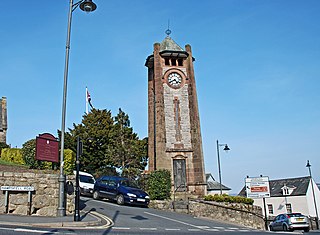
Carnforth is a market town and civil parish in the City of Lancaster in Lancashire, England, situated at the north-east end of Morecambe Bay. The parish of Carnforth had a population of 5,560 in the 2011 census, an increase from the 5,350 recorded in the 2001 census. The town is situated around 7 miles north of Lancaster, 17 miles south of Kendal, 40 miles east of Barrow-in-Furness and 28 miles northwest of Settle. The town is also close to the Cumbria/Lancashire border.
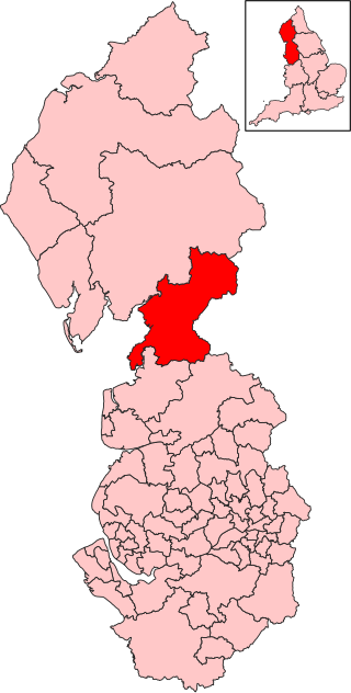
The City of Lancaster, or simply Lancaster, is a local government district with city status in Lancashire, England. It is named after its largest settlement, Lancaster, and also includes the towns of Carnforth, Heysham and Morecambe and a wider rural hinterland. The district has a population of 144,446 (2022), and an area of 219 square miles (567 km2).

Silverdale is a village and civil parish within the City of Lancaster district of Lancashire, England. The village stands on Morecambe Bay, near the border with Cumbria, 4.5 miles (7 km) north west of Carnforth and 8.5 miles (14 km) of Lancaster. The parish had a population of 1,519 recorded in the 2011 census.
Morecambe and Lunesdale is a constituency represented in the House of Commons of the UK Parliament since the 2024 general election by Lizzi Collinge for Labour.

Wennington is a civil parish in the City of Lancaster district in Lancashire, England. The 2001 Census recorded the parish's population as 102, and the 2011 Census recorded it as 178.

Overton is a village and civil parish in Lancashire, England, south west of Lancaster and south of Morecambe between Heysham and the estuary of the River Lune. Neighbouring villages include Middleton and Sunderland Point; Glasson is on the opposite side of the river. The parish had a population of 1,070 at the 2011 Census.

Slyne-with-Hest is a civil parish in the City of Lancaster in Lancashire, England. It had a population of 3,163 recorded in the 2001 census, decreasing to 3,126 at the 2011 Census. The parish is north of Lancaster and consists of two villages; Slyne, on the A6 road, and Hest Bank on the coast.

Pilling is a village and civil parish within the Wyre borough of Lancashire, England. It is 6.5 miles (10.5 km) north-northeast of Poulton-le-Fylde, 9.4 miles (15.1 km) south-southwest of Lancaster and 14.5 miles (23.3 km) northwest of Preston, in a part of the Fylde known as Over Wyre.

Bare Lane is a railway station on the Morecambe Branch Line, which runs between Lancaster and Heysham Port. The station, situated 2+1⁄2 miles (4 km) west of Lancaster, serves the suburb of Bare in Morecambe, Lancashire. It is owned by Network Rail and managed by Northern Trains.

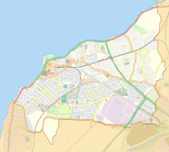
Morecambe is a seaside town and civil parish in the City of Lancaster district of Lancashire, England, on Morecambe Bay, part of the Irish Sea. In 2011 the parish had a population of 34,768.

Torrisholme is a suburb of Morecambe, Lancashire, on the North West coast of England. In the 2001 census, the Torrisholme Ward had a population of 6,758 living in 3,118 households, decreasing marginally to 6,755 at the 2011 Census.

The Leeds–Morecambe line, also known as the Bentham line, is a railway line running between Leeds, Skipton, Lancaster and Morecambe in northern England. The service is operated by Northern. The route covered by the service was historically part of the Midland Railway. The line is electrified at 25 kV AC overhead between Leeds City and Skipton- this section is known as the Airedale line.

Hest Bank railway station was opened by the Lancaster and Carlisle Railway (L&CR) three miles north of Lancaster Castle railway station. The line had been authorised in 1844 and a station was proposed for the village of Hest Bank, Lancashire, the following year. It opened in 1846 along with the line. The station continued to serve the village of Hest Bank until its closure in 1969. The site remains notable as being the point at which the present-day West Coast Main Line (WCML) comes nearest to the west coast. Views of Morecambe Bay can be glimpsed from trains on this section of the line.


