
Monk Bretton is a village in the Metropolitan Borough of Barnsley in South Yorkshire, England. It lies approximately two miles north-east from Barnsley town centre. Until 1974 it was in the West Riding of Yorkshire.

Brimpton is a mostly rural village and civil parish in West Berkshire, England. Brimpton is centred 4.5 miles (7.2 km) ESE of the town of Newbury.

The Barony of Kendal is a subdivision of the English historic county of Westmorland. It evolved from one of two ancient baronies that make up the county, the other being the Barony of Westmorland. In 1974, the entire county became part of the modern county of Cumbria and ceased to have an administrative function. At the same time, Kendal borough along with some other rural and urban districts in Westmorland was merged with the neighbouring parts of Lancashire, Furness and Cartmel, and also the Sedbergh Rural District of the West Riding of Yorkshire into the new South Lakeland district of the new county.

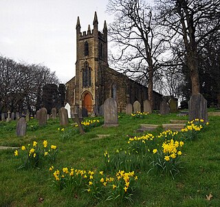
Knodishall, a village in Suffolk, England, lies 3.5 miles (6 km) south-east of Saxmundham, 1 mile (2 km) south-west of Leiston, and 3 miles from the coast, in the Blything Hundred. Most dwellings are now at Coldfair Green; just a few remain in the original village by the parish Church of St Lawrence, which falls gently on the north side of the Hundred River valley. It is now an outlier of Knodishall Common, a settlement a mile to the south-east. The estimated parish population was 790 in 2019.

The Barony of Halton, in Cheshire, England, comprised a succession of 15 barons and hereditary Constables of Chester under the overlordship of the Earl of Chester. It was not an English feudal barony granted by the king but a separate class of barony within the County Palatine of Chester.

Cockersand Abbey is a former abbey and former civil parish near Cockerham in the City of Lancaster district of Lancashire, England. It is situated near the mouth of the River Cocker.

Seacourt is a deserted medieval village (DMV) in the civil parish of Wytham, in the Vale of White Horse district, in Oxfordshire, England, near the city of Oxford. The site is now mostly beneath the Oxford Western By-pass (A34), about 0.3 miles (0.48 km) south of the Seacourt/Hinksey Stream crossing.

Tortington is a small village and former civil parish, now in the parish of Arundel, in the Arun district of West Sussex, England. It lies between the Arundel to Ford and the Arundel to Chichester roads, 1.6 miles (2.6 km) southwest of Arundel. In 1961 the parish had a population of 617. On 1 April 1985 the parish was abolished and merged with Arundel, Ford, Slindon and Walberton.
Skerton is an area in the north of Lancaster, Lancashire, England, on the other side of the River Lune to the castle. It was formerly a township, but in the late 1800s it was incorporated into Lancaster and the neighbouring townships. Skerton Bridge takes the A6 southwards towards the city centre.

Inskip-with-Sowerby is a civil parish in the Borough of Wyre, in Lancashire, England. A part of the Fylde, the parish includes the village of Inskip and the hamlets Crossmoor to the west and Sowerby to the east. Also Inskip Moss Side lies about a mile north-west of the village at grid reference SD452391. In 2011 it had a population of 840.

Cottisford is a village and civil parish in Oxfordshire, about 3.5 miles (5.6 km) south of Brackley in neighbouring Northamptonshire. The parish's northern and northwestern boundaries form part of the boundary between the two counties. The parish includes the hamlet of Juniper Hill about 1 mile (1.6 km) northwest of Cottisford. The 2011 Census recorded the parish's population as 216.

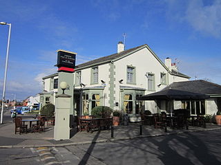
Norton is an area in the eastern part of the town of Runcorn, in the Halton district, in the ceremonial county of Cheshire, England. It was originally a separate village 3 miles (5 km) to the east of Runcorn, but in the 1970s and 1980s became absorbed within Runcorn by the expansion of its new town.
Lytham Priory was an English Benedictine priory in Lytham, Lancashire. It was founded between 1189 and 1194 by Richard Fitz Roger as a cell of Durham Priory. It was dedicated to Saint Cuthbert and lasted until Henry VIII dissolved the monasteries in 1530s. In the 18th century, a manor house, Lytham Hall, was built on the site of the priory.
Carleton is a village on the coastal plain of the Fylde in the Borough of Wyre in Lancashire, England. It consists of Great Carleton, Little Carleton, Norcross and Whiteholme and is situated close to Poulton-le-Fylde. Other nearby settlements include Thornton, Bispham and Blackpool. Historically, Carleton was in the parish of Poulton-le-Fylde. It borders the Borough of Blackpool immediately to the west.

The Constable of Chester was a mediaeval hereditary office held by the Barons of Halton. The functions of the Constable are unclear, possibly they related to the custody of Chester Castle, as was the main function of most mediaeval constables, but Sanders (1960) says the office-holder was constable for the entire County Palatine.
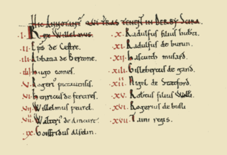
The Domesday Book of 1086 AD lists King William the Conqueror's tenants-in-chief in Derbyscire (Derbyshire), following the Norman Conquest of England:
Lancaster Rural District was a rural district in the county of Lancashire, England. It was created in 1894 and abolished in 1974 under the Local Government Act 1972.

Bulk is an area of Lancaster, Lancashire, England. It was formerly a township and a civil parish. The placename Bulke was recorded in 1346. The manor of Neuton was recorded in this area in the Domesday Book but by 1318 Newton was described as a hamlet within Bulk.

Ashton with Stodday is a former township and civil parish, now in the parish of Thurnham, in the Lancaster district, in Lancashire, England.
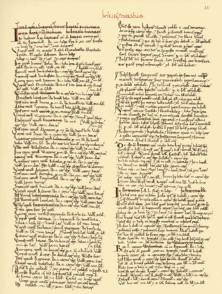
The Domesday Book of 1086 AD identifies King William the Conqueror's tenants-in-chief for historic Lancashire within Cestrescire (Cheshire) and Eurvicscire (Yorkshire). At the time of the Norman Conquest of England, the County of Cheshire included Inter Ripam et Mersam which became South Lancashire, while the West Riding of the County of Yorkshire included what became North Lancashire.


