
Longridge is a market town and civil parish in the borough of Ribble Valley in Lancashire, England. It is situated 8 miles (13 km) north-east of the city of Preston, at the western end of Longridge Fell, a long ridge above the River Ribble. The nearest villages are Grimsargh, 2 miles (3 km) to the southeast, and Ribchester 4 miles (6 km) to the southeast. The parish of Longridge had a population of 7,546 recorded in the 2001 census, increasing to 7,724 at the 2011 Census.

Carnforth is a market town and civil parish in the City of Lancaster in Lancashire, England, situated at the north-east end of Morecambe Bay. The parish of Carnforth had a population of 5,560 in the 2011 census, an increase from the 5,350 recorded in the 2001 census. The town is situated around 7 miles north of Lancaster, 17 miles south of Kendal, 40 miles east of Barrow-in-Furness and 28 miles northwest of Settle. The town is also close to the Cumbria/Lancashire border.
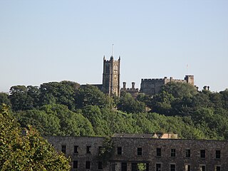
The City of Lancaster, or simply Lancaster, is a local government district with city status in Lancashire, England. It is named after its largest settlement, Lancaster, and also includes the towns of Carnforth, Heysham and Morecambe and a wider rural hinterland. The district has a population of 144,446 (2022), and an area of 219 square miles (567 km2).
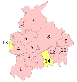
A civil parish is a subnational entity, forming the lowest unit of local government in England. There are 219 civil parishes in the ceremonial county of Lancashire; Blackpool is completely unparished; Pendle and Ribble Valley are entirely parished. At the 2001 census, there were 587,074 people living in the 219 parishes, accounting for 41.5 per cent of the county's population.

Goosnargh is a village and civil parish in the City of Preston district of Lancashire, England.
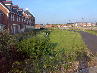
Buckshaw Village is a 21st-century residential and industrial area between the towns of Chorley and Leyland in Lancashire, England, developed on the site of the former Royal Ordnance Factory (ROF) Chorley. It had a population of 4,000. It is divided between the civil parishes of Euxton (south) and Whittle-le-Woods in Chorley, with the north western part being in Leyland unparished area in South Ribble district.
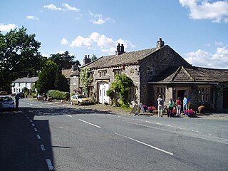
Bolton-by-Bowland is a village and civil parish in the Ribble Valley district of Lancashire, England. Before 1974, the village was part of Bowland Rural District in the West Riding of Yorkshire. According to the census of 2001, the parish had a population of just 498, rising marginally to 499 at the census of 2011.

Bowland-with-Leagram is a civil parish in the Ribble Valley district of Lancashire, England, covering part of the Forest of Bowland. According to the census, the parish had a population of 181 in 1951, 128 in 2001 and 169 at the Census 2011.

Hesketh Bank is a village in the West Lancashire district of Lancashire, England. It is situated approximately 7 miles (11 km) north-east of Southport and 7 miles (11 km) south-west of Preston. The village is within the civil parish of Hesketh-with-Becconsall, which includes the village of Becconsall immediately to the south and which borders the Ribble Estuary to the north. The parish had a population of 4,187 at the 2021 Census. Hesketh Bank, Becconsall, and the village of Tarleton to the south form a single built-up area with a population of 8,755.

Pilling is a village and civil parish within the Wyre borough of Lancashire, England. It is 6.5 miles (10.5 km) north-northeast of Poulton-le-Fylde, 9.4 miles (15.1 km) south-southwest of Lancaster and 14.5 miles (23.3 km) northwest of Preston, in a part of the Fylde known as Over Wyre.

Henhull is a former civil parish, now in the parishes of Burland and Acton and Nantwich, in the unitary authority area of Cheshire East and the ceremonial county of Cheshire, England, which lies to the north west of Nantwich. For administrative purposes, it was combined with adjacent civil parishes of Acton and Edleston to form a total area of 765 hectares. The parish was predominantly rural with scattered farms and houses and no large settlements. In 2019 a 1,100-house development called Kingsbourne was being built in the east of the parish as an extension to the town of Nantwich. Henhull civil parish also included the hamlets of Basin End, Bluestone, Welshmen's Green and part of Burford. Nearby villages include Acton and Rease Heath.

Thornton-le-Moors is a village and civil parish in the unitary authority of Cheshire West and Chester and the ceremonial county of Cheshire, England. At the census of 2001 it had a population of 260, reducing slightly to 253 at the 2011 census.
Hutton is a village and civil parish in Lancashire, England. It is located 3 miles (4.8 km) south west of Preston, in the South Ribble borough and parliamentary constituency. The population of the civil parish at the 2011 census was 2,277.
Clayton-le-Dale is a village and civil parish situated on the A59 road near Blackburn, in Lancashire, England. The population of the civil parish as of the 2011 census was 1,228. The village is in the Ribble Valley local government district.

Grindleton is a village and civil parish in the Ribble Valley district of the English county of Lancashire, traditionally in the West Riding of Yorkshire. Its 3,700 acres sit within the Forest of Bowland. The population of the civil ward taken at the 2011 census was 772.

Tunstall is a village in north Lancashire, England. It is 11.1 miles (18 km) northeast of Lancaster on the A683 road between Lancaster and Kirkby Lonsdale. In the 2001 census the civil parish of Tunstall had a population of 105. In the 2011 census Tunstall was grouped with Cantsfield to give a total of 223.

Sawley is a village and civil parish in the Borough of Ribble Valley in Lancashire, England. The population of the civil parish was 305 at the 2001 Census, rising to 345 at the 2011 census. It is situated north-east of Clitheroe, on the River Ribble. It was historically part of the West Riding of Yorkshire.

Heaton-with-Oxcliffe is a civil parish situated near the River Lune. it is in the City of Lancaster and the English county of Lancashire. The parish contains the villages of Heaton, Oxcliffe Hill, plus the area around Salt Ayre, and had a population of 2,225 recorded in the 2001 census, decreasing to 2,059 at the 2011 census.
Cantsfield is a civil parish in Lancaster, Lancashire, England. It contains 16 listed buildings that are recorded in the National Heritage List for England. Of these, one is listed Grade II*, the middle grade, and the others are at Grade II, the lowest grade. The major building in the parish is Thurland Castle; this building and structures associated with it are listed. The parish contains the village of Cantsfield and is otherwise rural. The other listed buildings include houses in the village, a bridge, two milestones, and two boundary stones.
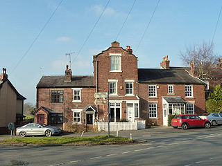
Hilldale is a civil parish in the West Lancashire district of Lancashire, England, containing the village of Hill Dale and the neighbouring hamlet of Andertons Mill. Formerly part of Wrightington, Hilldale became a separate civil parish in 1999. As of 2011, Hilldale has a population of 581.


