
Dan is an ancient city mentioned in the Hebrew Bible, described as the northernmost city of the Kingdom of Israel, and belonging to the tribe of Dan, its namesake. It was later the site of a royal sanctuary built by Jeroboam.

The Shephelah or Shfela, or the Judaean Foothills, is a transitional region of soft-sloping rolling hills in south-central Israel stretching over 10–15 km (6.2–9.3 mi) between the Judaean Mountains and the Coastal Plain. The different use of the term "Judean Plain", as either defining just the Coastal Plain segment stretching along the Judaean Mountains, or also including, or only referring to, the Shfela, often creates grave confusion.

Tel Rehov or Tell es-Sarem, is an archaeological site in the Bet She'an Valley, a segment of the Jordan Valley, Israel, approximately 5 kilometres (3 mi) south of Beit She'an and 3 kilometres (2 mi) west of the Jordan River. It was occupied in the Bronze Age and Iron Age.

Hazael was a king of Aram-Damascus mentioned in the Bible. Under his reign, Aram-Damascus became an empire that ruled over large parts of contemporary Syria and Israel-Samaria. While he was likely born in the greater Damascus region of today, his place of birth is unknown, with both Bashan and the Beqaa Valley being favoured by different historians.
Libnah or Lobana was an independent city, probably near the western seaboard of Israel, with its own king at the time of the Israelite conquest of Canaan. It is thought to have been an important producer of revenue, and one that rebelled against the Judahite crown.

Gath or Gat was one of the five cities of the Philistine pentapolis during the Iron Age. It was located in northeastern Philistia, close to the border with Judah. Gath is often mentioned in the Hebrew Bible and its existence is confirmed by Egyptian inscriptions. Already of significance during the Bronze Age, the city is believed to be mentioned in the El-Amarna letters as Gimti/Gintu, ruled by the two Shuwardata and 'Abdi-Ashtarti. Another Gath, known as Ginti-kirmil also appears in the Amarna letters.

Maresha was an Iron Age city mentioned in the Hebrew Bible, whose remains have been excavated at Tell Sandahanna, an archaeological mound or 'tell' renamed after its identification to Tel Maresha. The ancient Judahite city became Idumaean after the fall of Judah in 586 BCE, and after Alexander's conquest of the region in 332 BCE became Hellenised under the name Marisa or Marissa. The tell is situated in Israel's Shephelah region, i.e. in the foothills of the Judaean Mountains, about 1.5 kilometres (0.93 mi) south of Beit Gubrin.
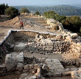
Khirbet Qeiyafa, also known as Elah Fortress and in Hebrew as Horbat Qayafa, is the site of an ancient fortress city overlooking the Valley of Elah and dated to the first half of the 10th century BCE. The ruins of the fortress were uncovered in 2007, near the Israeli city of Beit Shemesh, 30 km (20 mi) from Jerusalem. It covers nearly 2.3 ha and is encircled by a 700-meter-long (2,300 ft) city wall constructed of field stones, some weighing up to eight tons. Excavations at site continued in subsequent years. A number of archaeologists, mainly the two excavators, Yosef Garfinkel and Saar Ganor, have claimed that it might be one of two biblical cities, either Sha'arayim, whose name they interpret as "Two Gates", because of the two gates discovered on the site, or Neta'im; and that the large structure at the center is an administrative building dating to the reign of King David, where he might have lodged at some point. This is based on their conclusions that the site dates to the early Iron IIA, ca. 1025–975 BCE, a range which includes the biblical date for the biblical Kingdom of David. Others suggest it might represent either a North Israelite, Philistine, or Canaanite fortress, a claim rejected by the archaeological team that excavated the site. The team's conclusion that Khirbet Qeiyafa was a fortress of King David has been criticised by some scholars. Garfinkel (2017) changed the chronology of Khirbet Qeiyafa to ca. 1000–975 BCE.
Eglon was a Canaanite city-state mentioned in the Hebrew Bible. According to the Book of Joshua, Debir, king of Eglon, joined a confederation against Gibeon when that city made peace with Israel. The five kings involved were slain and Eglon was later conquered and its inhabitants condemned to destruction. It was thereafter included in the territory of the Tribe of Judah, although it is not mentioned outside of the Book of Joshua.
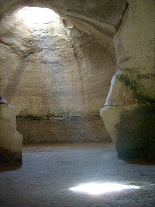
Beit Guvrin-Maresha National Park is a national park in central Israel, containing a large network of caves recognized by UNESCO as a World Heritage Site. The national park includes the remains of the historical towns of Maresha, one of the important towns of Judah during the First Temple Period, and Bayt Jibrin, a depopulated Palestinian town known as Eleutheropolis in the Roman era. However, Maresha and Bayt Jibrin are not part of the UNESCO site, which covers only the cave network.

Tel Jezreel is an archaeological site in the eastern Jezreel Valley in northern Israel. The ancient city of Jezreel served as a main fortress of the Northern Kingdom of Israel under king Ahab in the 9th century BCE.
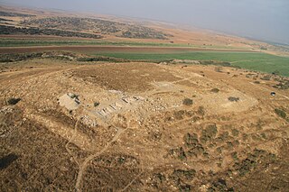
Tel Burna is an archaeological site located in the Shephelah, along the banks of Nahal Guvrin, not far from modern-day Qiryat Gat. Tel Burna is located near Beit Guvrin/Maresha, Tel Goded, Lachish, Tell es-Safi/Gath and Tel Zayit. The site is thought to have been one of a series of sites along the border between Judah and Philistia.
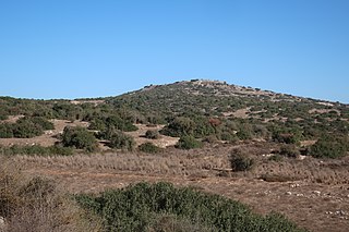
Tell ej-Judeideh is a tell in modern Israel, lying at an elevation of 398 metres (1,306 ft) above sea-level. The Arabic name is thought to mean, "Mound of the dykes." In Modern Hebrew, the ruin is known by the name Tell Goded.

Tel Erani or Tell esh-Sheikh Ahmed el-ʿAreini is a multi-period archaeological site on the outskirts of Kiryat Gat in the Southern District of Israel. It is also known by the name ʻIrâq el-Menshiyeh, although thought to have borne the original Arabic name of Menshiyet es-Saḥalīn. The tell was first occupied in the Chalcolithic period, but its most notable remains are from the Bronze Age and Iron Age, when it was the site of a substantial Philistine city with links to Egypt. It has been identified with the biblical cities of Libnah, Gath, Mmst, Eglon and Makkedah, but none of these identifications are certain. The city was destroyed in the 6th century BCE, possibly by the Babylonians. In the Persian period, it was the site of a temple. There are also signs of settlement in the Hellenistic, Byzantine, and Mamluk periods. The Palestinian village of Iraq al-Manshiyya was located at the foot of the tell until it was depopulated in the 1948 Arab–Israeli War.

Oded Lipschits is an Israeli professor in the Department of Archaeology and Ancient Near East Studies at Tel Aviv University. In 1997 he earned his Ph.D. in Jewish History under the supervision of Nadav Na'aman. He has since become a Senior Lecturer and Full Professor at Tel Aviv University and served as the Director of the Tel Aviv Institute of Archaeology since 2011. Lipschits is an incumbent of the Austria Chair of the Archeology of the Land of Israel in the Biblical Period and is the Head and founder of the Ancient Israel Studies Masters program in the Department of Archaeology and Ancient Near East Studies.
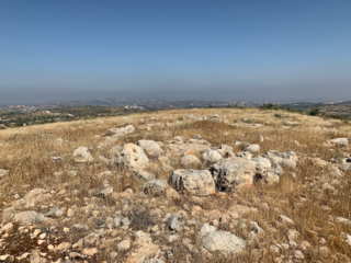
The so-called Bull Site is a 12th-century BCE open air ancient cult installation found at Dhahrat et-Tawileh, in the West Bank. The site is named for the bronze sacred bull statuette which was found at the site in 1977.

Lavnin (Hebrew: חורבת לבנין)(Arabic: خربة تل البيضة), is a late Bronze Age archaeological site situated in Israel's Adullam region, rising some 389 metres (1,276 ft) above sea level. The site lies 8 kilometres (5.0 mi) northwest of Beit Gubrin, and about 1 kilometer west-north-west of Khirbat Umm Burj, directly south of Nehusha.

'En Esur, also En Esur or Ein Asawir, is an ancient site located on the northern Sharon Plain, at the entrance of the Wadi Ara pass leading from the Coastal Plain further inland. The site includes an archaeological mound (tell), called Tel Esur or Tell el-Asawir, another unnamed mound, and two springs, one of which gives the site its name.
Avraham Faust is an Israeli archaeologist and professor at Bar-Ilan University. He directs excavations at Tel Eton, widely regarded as the probable site of biblical Eglon.
Tell el-Far'ah (South) is an archaeological site on the bank of HaBesor Stream in the northern Negev region, Israel. Not to be confused with the site Tell el-Far'ah (North). It is located between the modern settlements of Ein HaBesor and Urim, some 12 kilometres (7.5 mi) from the modern city of Ofakim and 20 kilometres (12 mi) from Gaza.


