Aguascalientes is a state in North Central Mexico that is divided into eleven municipalities. According to the 2020 Mexican Census, Aguascalientes is the sixth least populous state with 1,425,607 inhabitants and the fourth smallest by land area spanning 5,630.27 square kilometres (2,173.86 sq mi).
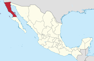
Baja California is a state in Northwest Mexico that is divided into six municipalities. According to the 2020 Mexican Census, Baja California is the 13th most populous state with 3,769,020 inhabitants and the 12th largest by land area spanning 73,290.08 square kilometres (28,297.46 sq mi).

Tecate is a municipality in the Mexican state of Baja California. Its municipal seat is located in the city of Tecate. According to the 2020 census, it had a population of 108,440 inhabitants. The municipality has an area of 3,079.0 km².

Playas de Rosarito Municipality is located in the northwestern part of the Mexican state of Baja California comprising part of the Tijuana metropolitan area. It lies just south of the city of Tijuana. Its municipal seat is the city of Rosarito. According to the 2020 census, the municipality had a population of 126,890 inhabitants. Its area is 513.32 km².

Coacalco de Berriozábal is a city and municipality in the State of Mexico, Mexico. The municipality lies in the Greater Mexico City conurbation, north of Mexico City. The municipal seat is San Francisco Coacalco and the municipality is named after Felipe Berriozábal (1829–1900), a Mexican politician and military leader.

The Guadalajara metropolitan area is the third most populous metropolitan area of the Mexican state of Jalisco and the third largest in the country after Greater Mexico City. It includes the core municipality of Guadalajara and the surrounding municipalities of Zapopan, Tlaquepaque, Tonalá, Tlajomulco de Zúñiga, El Salto, Ixtlahuacán de los Membrillos and Juanacatlán.

Hidalgo or Villa Hidalgo is a community located in the Mexican state of Coahuila. It is the municipal seat of Hidalgo Municipality. According to the INEGI census of 2010, Hidalgo has a population of 1,638 inhabitants. Its elevation is 150 meters above sea level.

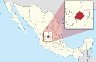
Pabellón de Arteaga is municipality in the Mexican state of Aguascalientes. It stands at 22°09′N102°16′W in the central part of the state. The city of Pabellón de Arteaga serves as its municipal seat. The municipality had a population of 41,862 and an area of 199.33 km². Its largest other town is named Emiliano Zapata.
Atotonilco de Tula is one of the 84 municipalities of Hidalgo. It is located in the central-southeastern part of the state of Hidalgo in Mexico. The municipal seat is Atotonilco de Tula. The municipality is located at a southern pass leading out of the Mezquital Valley to 86 kilometers north of Mexico City and about 180 km northeast of the state capital of Pachuca de Soto. The name comes from Nahuatl and means "place of hot springs" and otomi language is Padehe. The municipality covers an area of 31 km².

Mineral de la Reforma is one of the 84 municipalities of Hidalgo, in central-eastern Mexico. Adjacent to Pachuca in the same built up area, it is one of the fastest growing cities of Hidalgo State. As of 2005, the municipality had a total population of 68,704.

Xalatlaco is a town and municipality in Mexico State in Mexico. The municipality covers an area of 93.23 km². It is one of the 17 municipalities that border Mexico City, bordering the capital city's southwest side.

Felipe Carrillo Puerto is a municipality in the south-central part of the Mexican state of Quintana Roo. The municipal seat is the city of the same name. It was named after the assassinated local politician Felipe Carrillo Puerto. According to the 2014 census, the municipality's population was 81,742 inhabitants, living on an area of 13,806 square kilometres (5,331 sq mi).
Lafragua Municipality is a municipality in the Mexican state of Puebla. According to the National Statistics Institute (INEGI), it had a population of 10,551 inhabitants in the 2005 census. By the 2010 census it had dropped to 7,767 inhabitants, 761 of whom lived in Saltillo, the municipal seat. Its total area is 128.85 km². The Saltillo name comes from the Nahuatl words Atlcholoa in atl, which means water, and Choloa, meaning drip. Therefore, means water that drips. The name Lafragua is in honor of José María Lafragua.

Altamira is a port city on the Gulf of Mexico and is located near the southeastern tip of the state of Tamaulipas in Mexico. It is the second-largest city in the municipality of Altamira. To the south is Tampico, Mexico, also in this state.
Los Reyes is a municipality in the Mexican state of Veracruz, located about 100 kilometres (62 mi) south of the state capital Xalapa.

Citlaltépetl is a municipality in the Mexican state of Veracruz, located 223 kilometres (139 mi) northwest of the state capital of Xalapa and 99 kilometres (62 mi) south of the city of Tampico, Tamaulipas.
Xoxocotla is a municipality in the Mexican state of Veracruz, located 103 kilometres (64 mi) south of the state capital Xalapa.
Zaragoza is a municipality in the Mexican state of Veracruz, located 297 kilometres (185 mi) southeast of the state capital of Xalapa and 10 kilometres (6.2 mi) southwest of the city of Minatitlán.
Chunhuhub is a town in the Mexican state of Quintana Roo, Mexico, localized in state center, in the municipality of Felipe Carrillo Puerto. The population was 4,644 inhabitants at the 2010 census.