
The Red Cedar River is a tributary of the Grand River in central Michigan in the United States. The river is approximately 51.1 miles (82.2 km) long and drains a watershed of approximately 461 square miles (1,190 km2) in the Lansing–East Lansing metropolitan area and suburban and rural areas to the east.

The Unadilla River is a 71-mile-long (114 km) river in the Central New York Region of New York State. The river begins northeast of the hamlet of Millers Mills and flows generally south to the village of Sidney, where it converges with the Susquehanna River, which drains into the Chesapeake Bay, a bay of the Atlantic Ocean.

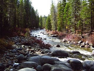
The Clavey River is a tributary of the Tuolumne River in the Sierra Nevada, located in the Stanislaus National Forest and Tuolumne County, California. The river is 31.3 miles (50.4 km) long, and is one of the few undammed rivers on the western slope of the Sierra. Via the Tuolumne River, the Clavey is part of the San Joaquin River watershed.
The Black River is a 41.1-mile-long (66.1 km) river on the Upper Peninsula of the U.S. state of Michigan, flowing mostly in Gogebic County into Lake Superior at 46°40′03″N90°02′57″W. Its source at 46°18′54″N90°01′15″W is a boreal wetland on the border with Iron County, Wisconsin. The northern section of the river, 14 miles (23 km) within the boundaries of the Ottawa National Forest, was designated a National Wild and Scenic River in 1992.

Wappinger Creek is a 41.7-mile-long (67.1 km) creek which runs from Thompson Pond to the Hudson River at New Hamburg in Dutchess County, New York, United States. It is the longest creek in Dutchess County, with the largest watershed in the county.

Otego Creek is a 32.7-mile-long (52.6 km) tributary of the Susquehanna River in Otsego County, New York. Otego Creek rises in the Town of Otsego and flows south through the Towns of Hartwick and Laurens, before joining the Susquehanna River southwest of the City of Oneonta.

Uvas Creek is a 29.5-mile-long (47.5 km) mainly southward-flowing stream originating on Loma Prieta peak of the Santa Cruz Mountains, in Santa Clara County, California, United States. The creek descends through Uvas Canyon County Park into Uvas Reservoir near Morgan Hill, and on through Uvas Creek Preserve and Christmas Hill Park in Gilroy. Upon passing U.S. Highway 101 it is known as Carnadero Creek, shortly before the confluence with the Pajaro River at the Santa Clara County - San Benito County boundary.

Stony Creek is a 73.5-mile (118.3 km)-long seasonal river in Northern California. It is a tributary of the Sacramento River, draining a watershed of more than 700 square miles (1,800 km2) on the west side of the Sacramento Valley in Glenn, Colusa, Lake and Tehama Counties.

The Middle Fork Kings River is a 37.2-mile (59.9 km) tributary of the Kings River in Kings Canyon National Park, California, in the southern Sierra Nevada. Draining 318 square miles (820 km2) – almost all of it wilderness – the Middle Fork is one of the largest wholly undeveloped watersheds in the state, with no dams or paved roads within its basin. The entire length of the Middle Fork is designated a National Wild and Scenic River.
Lidell Creek is a small creek in the town of Exeter in Otsego County, New York. Lidell Creek flows into Oaks Creek by Lidell Corners, south of the Hamlet of Schuyler Lake.

The Canajoharie Creek is a river that flows into the Mohawk River in the Village of Canajoharie in the U.S. State of New York. The name "Canajoharie" is a Mohawk language term meaning "the pot that washes itself", referring to the "Canajoharie Boiling Pot", a 20-foot (6.1 m) wide and 10-foot (3.0 m) deep pothole in the Canajoharie Creek, just south of the village of Canajoharie. Bowmans Creek is one main tributary that enters the creek east of the Hamlet of Sprout Brook. The other main tributary is Brimstone Creek which enters the creek north-northwest of the Village of Ames.
The Nowadaga Creek basin drains portions of the towns of Danube, Stark, and Little Falls, as well as a small portion of the town of Warren, in southern Herkimer County before converging with the Mohawk River in Indian Castle, New York. The drainage basin is approximately 49 percent forested. The creek has an average slope of 1.7 percent over its entire stream length of 10.0 miles. On a 1790 land patent map it is spelled "Inchanando Creek".
Steele Creek begins in an unnamed swamp south of Cedarville, New York, and flows northeast before emptying into the Mohawk River in the village of Ilion. Steele Creek travels through the Ilion Gorge and alongside NY-51 for most of its length. Steele Creek derives its name from Rudolph Stahl, who built the first grist mill in Ilion along the creek.
Cayadutta Creek is a river in Fulton and Montgomery counties in the state of New York. It begins northwest of Gloversville and flows in a general southward direction before flowing into the Mohawk River in Fonda. The Indian meaning of Cayadutta is "rippling waters" or "shallow water running over stones". This stream has commercial and historical importance as the cities of Johnstown and Gloversville lie on its banks.
Cobleskill Creek starts at Pine Mountain west of West Richmondville and flows east-northeast before converging with Schoharie Creek in Central Bridge, New York. The creek flows through the villages of Richmondville and Cobleskill.

Tapeats Creek is a creek located entirely within the Grand Canyon National Park. It flows southwest from its source near the North Rim of the canyon to the Colorado River at the base of the canyon. It was named by the Second Powell Expedition in the winter of 1871–1872 for a Southern Paiute Indian who claimed ownership of the stream. It contributes the largest amount of water to the Colorado of any tributary on the north side within the Grand Canyon.
Dinkey Creek is a large stream in the southern Sierra Nevada, in Fresno County, California. The creek is 29.2 miles (47.0 km) long, flowing undammed in a southerly direction through the Sierra National Forest. It is a tributary of the North Fork Kings River, in turn part of the Kings River system which drains into the de-watered Tulare Lake bed.

