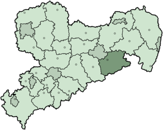
The Sächsische Schweiz is a former district (Kreis) in the south of the Free State of Saxony, Germany. Neighboring districts were Weißeritzkreis, the district-free city Dresden and the districts Kamenz and Bautzen. To the south it borders the Czech Republic.

Saxon Switzerland is a hilly climbing area and national park around the Elbe valley south-east of Dresden in Saxony, Germany. Together with the Bohemian Switzerland in the Czech Republic it forms the Elbe Sandstone Mountains.

Bad Schandau is a spa town in Germany, in the Sächsische Schweiz-Osterzgebirge district of the Free State of Saxony. It is situated on the right bank of the Elbe, at the mouth of the valley of the Kirnitzsch and in the area often described as Saxon Switzerland.

Oliver Perry-Smith was an American rock climber, mountaineer and skier who moved to Dresden in 1902 to attend a technical university.

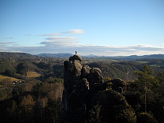
The Bastei is a rock formation rising 194 metres above the Elbe River in the Elbe Sandstone Mountains of Germany. Reaching a height of 305 metres above sea level, the jagged rocks of the Bastei were formed by water erosion over one million years ago. They are situated near Rathen, not far from Pirna southeast of the city of Dresden, and are the major landmark of the Saxon Switzerland National Park. They are also part of a climbing and hiking area that extends over the borders into the Bohemian Switzerland.
Rudolf Fehrmann, a German, was a pioneer rock climber at Elbsandsteingebirge near Dresden. He began climbing at the age of 17 and was soon at the leading edge of the fledgling sport. He and Oliver Perry-Smith, an American college student and fellow climber living in Dresden, became as close as brothers and formed a team which pushed the limits of risk and difficulty on the steep sandstone spires, making many first ascents. Early on, Fehrmann exerted leadership in both climbing ethics and environmental protection. He imagined the purest of climbing routes as "great lines", ascending directly up steep faces and cracks and sometimes presenting considerable difficulties, and he encouraged the use of rope-soled slippers and a minimum of metal protective devices in order to avoid destroying the fragile rock.
Saxon Switzerland National Park, is a National Park in the German Free State of Saxony, near the Saxon capital Dresden. It covers two areas of 93.5 km² (36.1 mi²) in the heart of the German part of the Elbe Sandstone Mountains, which is often called (the) Saxon Switzerland.

Rathmannsdorf is a township in the Saxon district of Sächsische Schweiz-Osterzgebirge. Rathmannsdorf is 2 km (1 mi) down the Elbe from Bad Schandau.

Reinhardtsdorf-Schöna is a municipality in the Sächsische Schweiz-Osterzgebirge district in the German federal state of Saxony. It has a population of approximately 1,600 and is located close to the Czech border in Saxon Switzerland, a popular tourist region.

The Saxon Elbeland is a term used in more recent times which describes a region along the Elbe, whose boundaries are not clearly defined, but which extends roughly from the Elbe Sandstone Mountains to Torgau. The best-known cities and town in this area are Dresden, Meißen, Riesa and Torgau. The term is largely synonymous with the region along the river known as the Upper Elbe (Oberelbe), i.e. the German section of the Elbe River nearest its source region.

The Nonne is a roughly 18-metre-high, isolated, standing sandstone rock and climbing peak in Saxon Switzerland in Germany. The rock is located southeast of Rathen, east of the rock chain of Rauenstein.

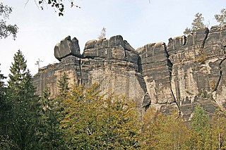
A climbing rock is a term used especially in Germany for an individual rock formation, rock face or rock group on which climbing is permitted. Designated climbing rocks are listed in climbing guidebooks and are usually incorporated and marked within the climbing areas of the alpine clubs. The concept is mainly relevant to climbing outside or on the fringes of the Alps. Special climbing regulations normally apply to climbing rocks, such as those for Saxon Switzerland, and there are usually restrictions to take account of conservation laws and requirements.

The Lokomotive is a striking climbing rock north of Kurort Rathen in Saxon Switzerland in Germany. The rock, which resembles a steam locomotive in appearance, is also known as Große Ruine, is about 30 metres high and is divided into two parts: known as Lokomotive-Dom and Lokomotive-Esse. The ridge between the two is called the Kesselgrat, the rock teeth next to the Esse as Pfeife ("Whistle"). For a short time there was a weather vane on the dome in the shape of a wheel. The Lokomotive rises on the massif of the Honigsteine.
The Mönch is a rock pinnacle and popular climbing peak in Saxon Switzerland in Germany near the spa town of Rathen. The weather vane on the summit, in the shape of a tin monk, is visible from afar and acts as a navigation aid.

The Barbarine is the best-known free-standing rock formation in the German part of the Elbe Sandstone Mountains. It is a rock pinnacle, 42.7 metres (140 ft) high, and is the symbol of Saxon Switzerland. It was first climbed on 19 September 1905.

The Pfaffenstein, formerly called the Jungfernstein, is a table hill, 434.6 m (1,426 ft) above sea level, in the Elbe Sandstone Mountains in Saxony. It lies west of the River Elbe near Königstein and is also referred to as "Saxon Switzerland in miniature" on account of its diverse structure.
Saxon Switzerland is the largest and one of the best-known climbing regions in Germany, located in the Free State of Saxony. The region is largely coterminous with the natural region of the same name, Saxon Switzerland, but extends well beyond the territory of the National Park within it. It includes the western part of the Elbe Sandstone Mountains and is the oldest non-Alpine climbing region in Germany. Its history of climbing dates back to the first ascent in modern times of the Falkenstein by Bad Schandau gymnasts in 1864. Currently, there are over 1,100 summits with more than 17,000 climbing routes in the Saxon Switzerland area.
The Frienstein, also called the Vorderes Raubschloss, is a rock formation, about 130 metres high, in Saxon Switzerland. It lies on the northern slopes of the Großer Winterberg in the Affensteine rocks. On the rock there was once a watchtower of the Barony of Wildenstein. Today the Frienstein is a popular climbing peak.

The Schwedenlöcher is a gorge-like side valley of the Amselgrund near Rathen in Saxon Switzerland.

Bernd Arnold is a German rock climber and mountaineer. He is known for more than 900 first ascents in the East German Saxon Switzerland climbing region. During the 1970s and 1980s, he established most of the hardest routes of the region and became one of the most influential German climbers of his era. He is well-known for climbing barefoot, even on very hard routes.
