Related Research Articles

In physical geography, tundra is a type of biome where tree growth is hindered by frigid temperatures and short growing seasons. The term tundra comes through Russian тундра from the Kildin Sámi word тӯндар meaning "uplands", "treeless mountain tract". There are three regions and associated types of tundra: Arctic tundra, alpine tundra, and Antarctic tundra.

The cryosphere is an all-encompassing term for the portions of Earth's surface where water is in solid form, including sea ice, lake ice, river ice, snow cover, glaciers, ice caps, ice sheets, and frozen ground. Thus, there is a wide overlap with the hydrosphere. The cryosphere is an integral part of the global climate system with important linkages and feedbacks generated through its influence on surface energy and moisture fluxes, clouds, precipitation, hydrology, atmospheric and oceanic circulation.

Peat is an accumulation of partially decayed vegetation or organic matter. It is unique to natural areas called peatlands, bogs, mires, moors, or muskegs. Sphagnum moss, also called peat moss, is one of the most common components in peat, although many other plants can contribute. The biological features of sphagnum mosses act to create a habitat aiding peat formation, a phenomenon termed 'habitat manipulation'. Soils consisting primarily of peat are known as histosols. Peat forms in wetland conditions, where flooding or stagnant water obstructs the flow of oxygen from the atmosphere, slowing the rate of decomposition. Peat properties such as organic matter content and saturated hydraulic conductivity can exhibit high spatial heterogeneity.
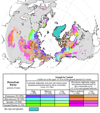
Permafrost is soil or underwater sediment which continuously remains below 0 °C (32 °F) for two years or more: the oldest permafrost had been continuously frozen for around 700,000 years. While the shallowest permafrost has a vertical extent of below a meter, the deepest is greater than 1,500 m (4,900 ft). Similarly, the area of individual permafrost zones may be limited to narrow mountain summits or extend across vast Arctic regions. The ground beneath glaciers and ice sheets is not usually defined as permafrost, so on land, permafrost is generally located beneath a so-called active layer of soil which freezes and thaws depending on the season.

Gelisols are an order in USDA soil taxonomy. They are soils of very cold climates which are defined as containing permafrost within two meters of the soil surface. The word "Gelisol" comes from the Latin gelare meaning "to freeze", a reference to the process of cryoturbation that occurs from the alternating thawing and freezing characteristic of Gelisols.

A talik is a layer of year-round unfrozen ground that lies in permafrost areas. In regions of continuous permafrost, taliks often occur underneath shallow thermokarst lakes and rivers, where the deep water does not freeze in winter and thus the soil underneath does not freeze either. Sometimes closed, open, and through taliks are distinguished. These terms refer to whether the talik is surrounded by permafrost, open at the top, or open both at the top and above an unfrozen layer beneath the permafrost.
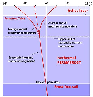
In environments containing permafrost, the active layer is the top layer of soil that thaws during the summer and freezes again during the autumn. In all climates, whether they contain permafrost or not, the temperature in the lower levels of the soil will remain more stable than that at the surface, where the influence of the ambient temperature is greatest. This means that, over many years, the influence of cooling in winter and heating in summer will decrease as depth increases.

A concrete slab is a common structural element of modern buildings, consisting of a flat, horizontal surface made of cast concrete. Steel-reinforced slabs, typically between 100 and 500 mm thick, are most often used to construct floors and ceilings, while thinner mud slabs may be used for exterior paving .

Thermokarst is a type of terrain characterised by very irregular surfaces of marshy hollows and small hummocks formed as ice-rich permafrost thaws. The land surface type occurs in Arctic areas, and on a smaller scale in mountainous areas such as the Himalayas and the Swiss Alps.
The thermal properties of soil are a component of soil physics that has found important uses in engineering, climatology and agriculture. These properties influence how energy is partitioned in the soil profile. While related to soil temperature, it is more accurately associated with the transfer of energy throughout the soil, by radiation, conduction and convection.

The Abisko Scientific Research Station (ANS) is a field research station managed by the Swedish Polar Research Secretariat. Situated on the south shore of Lake Torneträsk, it lies at the edge of the Abisko National Park. The station conducts ecological, geological, geomorphological and meteorological research in subarctic environments and each year about 500 scientists visit from all over the world. The varied geological, topographical and climatic conditions of the area allow it to be inhabited by a range of flora and fauna. These features, which have caused the area to be given National Park status, also make it an important place for scientific research, particularly of alpine and subalpine ecosystems.
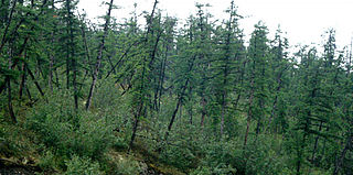
Drunken trees, tilted trees, or a drunken forest, is a stand of trees rotated from their normal vertical alignment.
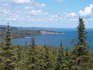
A boreal ecosystem is an ecosystem with a subarctic climate located in the Northern Hemisphere, approximately between 50° to 70°N latitude. These ecosystems are commonly known as taiga and are located in parts of North America, Europe, and Asia. The ecosystems that lie immediately to the south of boreal zones are often called hemiboreal. There are a variety of processes and species that occur in these areas as well.

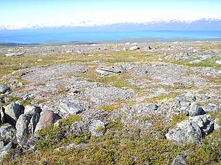
Palsas are peat mounds with a permanently frozen peat and mineral soil core. They are a typical phenomenon in the polar and subpolar zone of discontinuous permafrost. One of their characteristics is having steep slopes that rises above the mire surface. This leads to the accumulation of large amounts of snow around them. The summits of the palsas are free of snow even in winter, because the wind carries the snow and deposits on the slopes and elsewhere on the flat mire surface. Palsas can be up to 150 m in diameter and can reach a height of 12 m.

Arctic ecology is the scientific study of the relationships between biotic and abiotic factors in the arctic, the region north of the Arctic Circle. This region is characterized by stressful conditions as a result of extreme cold, low precipitation, a limited growing season and virtually no sunlight throughout the winter. The Arctic consists of taiga and tundra biomes, which also dominate very high elevations, even in the tropics. Sensitive ecosystems exist throughout the Arctic region, which are being impacted dramatically by global warming.
A frost boil, also known as mud boils, a stony earth circles, frost scars, or mud circles, are small circular mounds of fresh soil material formed by frost action and cryoturbation. They are found typically found in periglacial or alpine environments where permafrost is present, and may damage roads and other man-made structures. They are typically 1 to 3 metres in diameter.
A snow patch is a geomorphological pattern of snow and firn accumulation which lies on the surface for a longer time than other seasonal snow cover. There are two types to distinguish; seasonal snow patches and perennial snow patches. Seasonal patches usually melt during the late summer but later than the rest of the snow. Perennial snow patches are stable for more than two years and also have a bigger influence on surroundings.

The permafrost carbon cycle or Arctic carbon cycle is a sub-cycle of the larger global carbon cycle. Permafrost is defined as subsurface material that remains below 0o C for at least two consecutive years. Because permafrost soils remain frozen for long periods of time, they store large amounts of carbon and other nutrients within their frozen framework during that time. Permafrost represents a large carbon reservoir, one which was often neglected in the initial research determining global terrestrial carbon reservoirs. Since the start of 2000s, however, far more attention has been paid to the subject, with an enormous growth both in general attention and in the scientific research output.
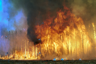
Terrestrial ecosystems found in the boreal regions of North America and Eurasia cover less than 17% of the earth's land surface, yet contain more than 30% of all carbon present in the terrestrial biome. In terms of carbon storage, the boreal region consists of three ecosystems: boreal forest, peatland, and tundra. Vast areas of the globe and are contributing greatly to atmospheric carbon release due to increased temperature and fire hazard. High northern latitudes will experience the most significant increase in warming on the planet as a result of increased atmospheric greenhouse gases thus placing in jeopardy the carbon sink in these areas. In addition to the release of carbon through the melting of permafrost, high intensity wildfires will become more common and thus contribute to the release of stored carbon. This means that the boreal forest and its fire regime is becoming an increasingly more significant factor in determining the global carbon budget.
The physical properties of soil, in order of decreasing importance for ecosystem services such as crop production, are texture, structure, bulk density, porosity, consistency, temperature, colour and resistivity. Soil texture is determined by the relative proportion of the three kinds of soil mineral particles, called soil separates: sand, silt, and clay. At the next larger scale, soil structures called peds or more commonly soil aggregates are created from the soil separates when iron oxides, carbonates, clay, silica and humus, coat particles and cause them to adhere into larger, relatively stable secondary structures. Soil bulk density, when determined at standardized moisture conditions, is an estimate of soil compaction. Soil porosity consists of the void part of the soil volume and is occupied by gases or water. Soil consistency is the ability of soil materials to stick together. Soil temperature and colour are self-defining. Resistivity refers to the resistance to conduction of electric currents and affects the rate of corrosion of metal and concrete structures which are buried in soil. These properties vary through the depth of a soil profile, i.e. through soil horizons. Most of these properties determine the aeration of the soil and the ability of water to infiltrate and to be held within the soil.
References
- ↑ Oelke, C., T. Zhang, M. Serreze, and R. Armstrong, 2003: Regional-scale modeling of soil freeze/thaw over the Arctic drainage basin. J. Geophys. Res., 108 (D10): Art.No. 4314 May 29, 2003.