
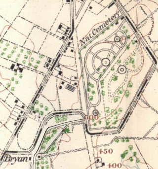
Gettysburg National Cemetery is a United States national cemetery in Gettysburg, Pennsylvania created for Union casualties from the Battle of Gettysburg in the American Civil War. The Battle of Gettysburg, which was fought between July 1 to 3, 1863, resulted in the largest number of casualties of any Civil War battle but also was considered the war's turning point, leading ultimately to the Union victory.

The Gettysburg Battlefield is the area of the July 1–3, 1863, military engagements of the Battle of Gettysburg within and around the borough of Gettysburg, Pennsylvania. Locations of military engagements extend from the 4-acre (1.6 ha) site of the first shot at Knoxlyn Ridge on the west of the borough, to East Cavalry Field on the east. A military engagement prior to the battle was conducted at the Gettysburg Railroad trestle over Rock Creek, which was burned on June 27.
The Peach Orchard is a Gettysburg Battlefield site at the southeast corner of the north-south Emmitsburg Road intersection with the Wheatfield Road. The orchard is demarcated on the east and south by Birney Avenue, which provides access to various memorials regarding the "momentous attacks and counterattacks in…the orchard on the afternoon of July 2, 1863."

Cemetery Ridge is a geographic feature in Gettysburg National Military Park, south of the town of Gettysburg, Pennsylvania, that figured prominently in the Battle of Gettysburg, July 1 to July 3, 1863. It formed a primary defensive position for the Union Army during the battle, roughly the center of what is popularly known as the "fish-hook" line. The Confederate States Army launched attacks on the Union positions on the second and third days of the battle, but were driven back both times.

Devil's Den is a boulder-strewn hill on the south end of Houck's Ridge at Gettysburg Battlefield, used by artillery and sharpshooters on the second day of the 1863 Battle of Gettysburg during the American Civil War. A tourist attraction since the memorial association era, several boulders are worn from foot traffic and the site includes numerous cannon, memorials, and walkways, including a bridge spanning two boulders.

Seminary Ridge is a dendritic ridge which was an area of Battle of Gettysburg engagements in July 1863 during the American Civil War (1861–1865), and of military installations during World War II (1941–1945).
The high-water mark of the Confederacy or high tide of the Confederacy refers to an area on Cemetery Ridge near Gettysburg, Pennsylvania, marking the farthest point reached by Confederate forces during Pickett's Charge on July 3, 1863. Similar to a high water mark of water, the term is a reference to arguably the Confederate Army's best chance of achieving victory in the war. The line of advance was east of "The Angle" stone wall.
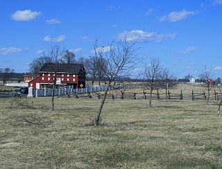
The Brian Farm is an American Civil War area of the Gettysburg Battlefield used during the Pickett's Charge. On January 23, 2004, the farm's buildings, Boundary Stone Wall, and ID tablet were designated historic district contributing structures after the tract was used for the 1918 Camp Colt and other postbellum camps.

The Gettysburg Battlefield Historic District is a district of contributing properties and over 1000 historic contributing structures and 315 historic buildings, located in Adams County, Pennsylvania. The district was added to the National Register of Historic Places on March 19, 1975. Most of the contributing elements of the Gettysburg Battlefield are on the protected federal property within the smaller Gettysburg National Military Park.

The Gettysburg Electric Railway was a borough trolley that provided summer access to Gettysburg Battlefield visitor attractions such as military engagement areas, monuments, postbellum camps, and recreation areas. Despite the 1896 Supreme Court ruling under the Takings Clause against the railway, battlefield operations continued until 1916. The trolley generating plant was leased by the Electric Light, Heat, and Power Company of Gettysburg to supply streetlights and homes until electricity was imported from Hanover.
The Round Top Branch was an extension of the Gettysburg and Harrisburg Railroad from the Gettysburg borough across the Gettysburg Battlefield to Round Top, Pennsylvania. The branch ran southward from the terminus of the railroad's main line, west of the school and St. Francis Xavier Cemetery, across the field of Pickett's Charge, south of Cemetery Ridge, east of Weikert Hill and Munshower Knoll, and through Round Top to a point between Little Round Top's east base and Taneytown Road. In addition to battlefield tourists, the line carried stone monoliths and statues for monuments during the battlefield's memorial association and commemorative eras and equipment, supplies and participants for Gettysburg Battlefield camps after the American Civil War.
McMillan Woods is a Gettysburg Battlefield forested area used during the Battle of Gettysburg and for camps after the American Civil War, including a CCC camp and the subsequent WWII POW camp at Gettysburg. The woods includes Rifle Pits and Earth Works from the battle.

The 1938 Gettysburg reunion was an encampment of American Civil War veterans on the Gettysburg Battlefield for the 75th anniversary of the Battle of Gettysburg. The gathering included approximately 25 veterans of the battle with a further 1,359 Federal and 486 Confederate attendees out of the 8,000 living veterans of the war. The veterans averaged 94 years of age. Transportation, quarters, and subsistence was federally funded for each veteran and their accompanying attendant. If an attendant was needed it was provided. President Franklin D. Roosevelt's July 3 reunion address preceded the unveiling of the Eternal Light Peace Memorial; a newsreel with part of the address was included in the Westinghouse Time Capsule for the 1939 New York World's Fair.
United States v. Gettysburg Electric Ry. Co., 160 U.S. 668 (1896), was a case to prevent trolley operations on the Gettysburg Battlefield. The dispute began in August 1891 when the Gettysburg Battlefield Memorial Association's board approved attorney Samuel Swope's motion to deny trolley right-of-way along GBMA roads. Despite the 1896 US Supreme Court ruling that the railway could be seized for historic preservation, as well as earlier legislative efforts to appropriate federal acquisition funds, create a War Department commission, and form the Gettysburg National Military Park; the trolley continued operations until obsolete in 1916.
The 72nd Pennsylvania Infantry Monument is an 1891 statuary memorial on the Gettysburg Battlefield. It is located on Cemetery Ridge, by The Angle and the copse of trees, where Union forces – including the 72nd Pennsylvania Infantry – beat back Confederate forces engaged in Pickett's Charge.
Emmor Cope was an American Civil War officer of the Union Army noted for the "Map of the Battlefield of Gettysburg from the original survey made August to October, 1863", which he researched by horseback as a sergeant after being ordered back to Gettysburg by Maj. Gen. George G. Meade. Cope is also noted for commemorative era battlefield administration and designs, including the layout of the 1913 Gettysburg reunion. Cope had enlisted as a Private of Company A,, temporarily detached to Battery C, 5th U.S. Artillery, and mustered out as a V Corps aide-de-camp of Maj Gen Gouverneur K. Warren.
Spangler Woods is a Gettysburg Battlefield location used during the Battle of Gettysburg and is near the Virginia Monument. On July 2, 1863, Garnett's Brigade bivouacked on the border of the woods.

The Wheatfield Road is a Gettysburg Battlefield crossroad from the Peach Orchard east-southeastward along the north side of The Wheatfield, north of the Valley of Death, and over the north foot of Little Round Top. In addition to modern tourist use, the road is notable for Battle of Gettysburg use and postbellum trolley use associated with the 1892-1896 US v. Gettysburg Electric Ry. case of the US Supreme Court.
The Gettysburg Battlefield Memorial Association (GBMA) was an historic preservation membership organization and is the eponym for the battlefield's memorial association era. The association was chartered by the Commonwealth of Pennsylvania on April 13, 1864, after attorney David McConaughy recommended on August 14, 1863, a preservation association to sell membership stock for battlefield fundraising. McConaughy transferred his land acquired in 1863 to the GBMA, and the association's boardmembers were initially local officials. The GBMA sold stock to raise money, hired a superintendent at $1000/yr, added to McConaughy's land holdings, and operated a wooden observation tower on East Cemetery Hill from 1878–95.
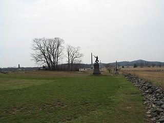
The High Water Mark of the Rebellion Monument is a Gettysburg Battlefield memorial which identifies the Confederate Army of Northern Virginia units of the infantry attack on the Battle of Gettysburg, third day, with a large bronze tablet, as well as the Union Army of the Potomac's "respective troops who met or assisted to repulse Longstreet's Assault." The memorial is named for the line of dead and wounded of Pickett's Charge which marked the deepest penetration into the Union line at The Angle when "4,500 men threw down their arms and came in as prisoners". The line is now generally marked with unit monuments which are also historic district contributing structures. The High Water Mark monument is accessible via Hancock Avenue which has parking spaces alongside, and a path leads to the site from a parking lot at the former Cyclorama Building at Gettysburg, which served for fifty years as a Gettysburg Battlefield visitor center by the National Park Service until it was demolished in 2013.

