
Tramlink, previously Croydon Tramlink and presently branded as London Trams, is a light rail tram system serving Croydon and surrounding areas in South London, England. It is the first operational tram system serving the London region since 1952. Tramlink is presently managed by London Trams, a public body part of Transport for London (TfL), and has been operated by FirstGroup since 2017. It is one of two light rail networks in Greater London, the other being the Docklands Light Railway. Tramlink is the fourth-busiest light rail network in the UK behind the Docklands Light Railway, Manchester Metrolink and Tyne and Wear Metro.

Carshalton is a town, with a historic village centre, in south London, England, within the London Borough of Sutton. It is situated 9.5 miles (15.3 km) south-southwest of Charing Cross, in the valley of the River Wandle, one of the sources of which is Carshalton Ponds in the middle of the village. Prior to the creation of Greater London in 1965, Carshalton was in the administrative county of Surrey.
Cheam is a suburb of London, England, 10.9 miles (17.5 km) southwest of Charing Cross. It is divided into North Cheam, Cheam Village and South Cheam. Cheam Village contains the listed buildings Lumley Chapel and the 16th-century Whitehall. It is adjacent to two large parks, Nonsuch Park and Cheam Park. Nonsuch Park contains the listed Nonsuch Mansion. Parts of Cheam Park and Cheam Village are in a conservation area. Cheam is bordered by Worcester Park to the northwest, Morden to the northeast, Sutton to the east, Epsom, Ewell and Stoneleigh to the west and Banstead and Belmont to the south.

Wallington is a town in the London Borough of Sutton, South London, England, 9.7 miles (15.6 km) south-west of Charing Cross. Before the Municipal Borough of Beddington and Wallington merged into the London Borough of Sutton in Greater London in 1965, it was part of the county of Surrey. Wallington is a post town in the SM postcode area.

The London Borough of Sutton is an Outer London borough in London, England. It covers an area of 43 km2 (17 sq mi) and is the 80th largest local authority in England by population. It borders the London Borough of Croydon to the east, the London Borough of Merton to the north and the Royal Borough of Kingston upon Thames to the north-west; it also borders the Surrey boroughs of Epsom and Ewell to the west and Reigate and Banstead to the south. The local authority is Sutton London Borough Council. Its principal town is Sutton.

The River Wandle is a right-bank tributary of the River Thames in south London, England. With a total length of about 9 miles (14 km), the river passes through the London boroughs of Croydon, Sutton, Merton and Wandsworth, where it reaches the Thames. A short headwater – the Caterham Bourne – is partially in Surrey, the historic county of the river's catchment. Tributaries of the Wandle include Carshalton Ponds and Norbury Brook.

Sutton is a town in the London Borough of Sutton in South London, England. It is the administrative headquarters of the Outer London borough, on the lower slopes of the North Downs. It is 10 miles (16 km) south-southwest of Charing Cross, one of the fourteen metropolitan centres in the London Plan.

Shirley is an area of south London, England, within the London Borough of Croydon. It lies north of Spring Park and Addington, east of Addiscombe, south of Monks Orchard and west of West Wickham, and 10 miles south-southeast of Charing Cross. Prior to the creation of Greater London in 1965, Shirley was in the administrative county of Surrey.

South Croydon in south London is the area surrounding the valley south of central Croydon and running as far south as the former Red Deer public house on the Brighton Road. It is bounded by Waddon to the West and Selsdon and Sanderstead to the East. It is part of the South Croydon (CR2) post town and in the London Borough of Croydon.
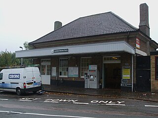
Carshalton Beeches railway station is in south Carshalton in the London Borough of Sutton in south London. The station, and all trains serving it, is operated by Southern, and is in Travelcard Zone 5. It is between Wallington and Sutton, 13 miles 72 chains down the line from London Bridge, measured via Forest Hill.

The A2022 is a non-primary road in England. It runs south-west into the foothills of the North Downs from West Wickham in the London Borough of Bromley through Addington, Forestdale, Selsdon, Sanderstead, Purley, the Woodcote part of that town, Banstead in Surrey and Epsom Downs through which it descends to a similar altitude as at its beginning to end at Epsom.

London Buses route 157 is a Transport for London contracted bus route in London, England. Running between Crystal Palace bus station and Morden station, it is operated by Go-Ahead London.

Benhilton is a suburban parish in north Sutton, Greater London. It is dominated by All Saints Church, which is a Grade II* listed building designed by Samuel Sanders Teulon in a Gothic Revival style and opened in 1863. It also contains All Saints Benhilton, C of E Primary and Greenshaw High School.
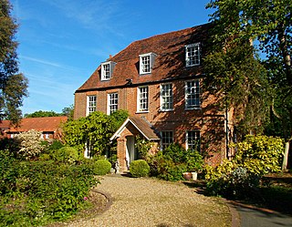
Carshalton Park is a public park in Carshalton, in the London Borough of Sutton. It is situated south of the High Street, in the area bounded by Ruskin Road, Ashcombe Road, Woodstock Road and The Park. Carshalton Park and some of the surrounding houses, are within a conservation area.
Sutton High Street is a high street running north–south through the town of Sutton in the London Borough of Sutton.
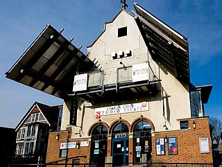
The Charles Cryer Theatre is a studio theatre located in the High Street in Carshalton in the London Borough of Sutton. The theatre is named after the man who led the campaign to open the Secombe Theatre in neighbouring Sutton. It was opened by Prince Edward in 1991. It closed in 2016, but in November 2019 it reopened under new management.
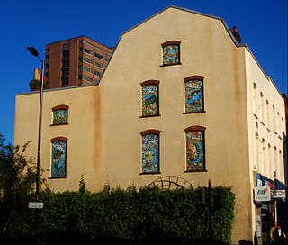
The Sutton Twin towns mural is a large mural in the form of seven individual paintings situated in Sutton High Street in the town of Sutton in Greater London, England. It is one of six works of public art in Sutton town centre.

There are four conservation areas within the town of Sutton. One of these is in Sutton town centre - the Sutton Town Centre High Street Crossroads Conservation Area - while the other three are residential: Grove Avenue, Landseer Road and the Sutton Garden Suburb.
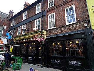
The Dog & Bull is a public house in Croydon, England. It is a Grade II listed, 18th-century building with a 19th-century frontage in Surrey Street, on the site of a previous 12th- or 13th-century inn called The Bell.


