
Mount Monadnock, or Grand Monadnock, is a 3,165 ft (965 m) mountain in the towns of Jaffrey and Dublin, New Hampshire. It is the most prominent mountain peak in southern New Hampshire and is the highest point in Cheshire County. It lies 38 miles (61 km) southwest of Concord and 62 miles (100 km) northwest of Boston. At 3,165 feet (965 m), Mount Monadnock is nearly 1,000 feet (305 m) higher than any other mountain peak within 30 miles (48 km) and rises 2,000 feet (610 m) above the surrounding landscape. It is known for being featured in the writings of Ralph Waldo Emerson and Henry David Thoreau.
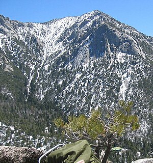
Tahquitz Peak is a granite, 8,846-foot-tall (2,696 m) rock formation located on the high western slope of the San Jacinto mountain range in Riverside County, Southern California, United States, above the mountain town of Idyllwild. Tahquitz has a steep approach hike, leading to a roughly 1000-foot face. Tahquitz, which can refer to both the rock outcrop and the outcrop's parent peak, is a popular hiking destination to the fire lookout station and the rock climbing area.

Mount Whitney is the tallest mountain in the contiguous United States and the Sierra Nevada, with an elevation of 14,505 feet (4,421 m). It is located in East–Central California, on the boundary between California's Inyo and Tulare counties, 84.6 miles (136.2 km) west-northwest of the lowest point in North America at Badwater Basin in Death Valley National Park at 282 ft (86 m) below sea level. The west slope of the mountain is in Sequoia National Park and the summit is the southern terminus of the John Muir Trail which runs 211.9 mi (341.0 km) from Happy Isles in Yosemite Valley. The east slope is in the Inyo National Forest in Inyo County.

Sequoia National Park is an American national park in the southern Sierra Nevada east of Visalia, California. The park was established on September 25, 1890 to protect 404,064 acres of forested mountainous terrain. Encompassing a vertical relief of nearly 13,000 feet (4,000 m), the park contains the highest point in the contiguous United States, Mount Whitney, at 14,505 feet (4,421 m) above sea level. The park is south of, and contiguous with, Kings Canyon National Park; both parks are administered by the National Park Service together as the Sequoia and Kings Canyon National Parks. UNESCO designated the areas as Sequoia-Kings Canyon Biosphere Reserve in 1976.

The San Gabriel Mountains are a mountain range located in northern Los Angeles County and western San Bernardino County, California, United States. The mountain range is part of the Transverse Ranges and lies between the Los Angeles Basin and the Mojave Desert, with Interstate 5 to the west and Interstate 15 to the east. This range lies in, and is surrounded by, the Angeles National Forest, with the San Andreas Fault as the northern border of the range.
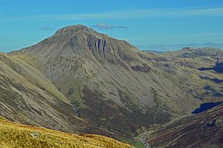
Great Gable is a mountain in the Lake District, United Kingdom. It is named for its appearance as a pyramid from Wasdale, though it is dome-shaped from most other directions. It is one of the most popular of the Lakeland fells, and there are many different routes to the summit. Great Gable is linked by the high pass of Windy Gap to its smaller sister hill, Green Gable, and by the lower pass of Beck Head to its western neighbour, Kirk Fell.

The Angeles National Forest (ANF) of the U.S. Forest Service is located in the San Gabriel Mountains and Sierra Pelona Mountains, primarily within Los Angeles County in southern California. The ANF manages a majority of the San Gabriel Mountains National Monument.

Palomar Mountain is a mountain ridge in the Peninsular Ranges in northern San Diego County. It is famous as the location of the Palomar Observatory and Hale Telescope, and known for the Palomar Mountain State Park.

Mount Hamilton is a mountain in California's Diablo Range, in Santa Clara County, California. Mount Hamilton, at 4,265 feet (1,300 m) is a mountain overlooking Santa Clara Valley and is the site of Lick Observatory, the World's first permanently occupied mountain-top observatory. The asteroid 452 Hamiltonia, discovered in 1899, is named after the mountain. Golden eagle nesting sites are found on the slopes of Mount Hamilton. On clear days, Mount Tamalpais, the Santa Cruz Mountains, Monterey Bay, the Monterey Peninsula, and even Yosemite National Park are visible from the summit of the mountain.

The Shasta–Trinity National Forests are federally designated forests in northern California, United States. Combined, they are the largest National Forest in California and are managed by the U.S. Forest Service. The 2,210,485 acre combined-forest encompasses five wilderness areas, hundreds of mountain lakes and 6,278 miles (10,103 km) of streams and rivers. Major features include Shasta Lake, the largest man-made lake in California and Mount Shasta, elevation 14,179 feet (4,322 m).

The High Sierra Trail (HST) is a hiking trail in Sequoia National Park, California. The trail crosses the Sierra Nevada from west to east. According to the Yosemite Decimal System, the HST is a Class 1/Class 2 trail, which means simple scrambling, with the possibility of occasional use of the hands for balance.

Mount Langley is located on the crest of the Sierra Nevada, on the boundary between Inyo and Tulare counties, in eastern California in the southwestern United States. To the east is Owens Valley, and to the west is the Kern River Valley. It is the ninth-highest peak in the state and the seventh-highest in the Sierra. Mount Whitney, the highest peak in the contiguous United States, lies 4.8 miles (7.7 km) to the northwest. Mt. Langley also has the distinction of being the southernmost fourteener in the United States.
The McNally Fire was a massive wildfire in the Sequoia National Forest which burned 150,696 acres (609.8 km2) in July and August 2002, and the largest wildfire of the 2002 California wildfire season. The fire burned from July 21 to August 29, 2002 through the Sequoia and Inyo National Forest, as well as 5% of Giant Sequoia National Monument. It destroyed 14 structures and cost an estimated $45.7 million to put out. The blaze was started due to the "careless use of fire" near the Roads End Resort in Kern Canyon, and spread east through the canyon and threatened the communities of Johnsondale and Ponderosa. It burned within one mile of the Packsaddle Grove of giant sequoias.
Mount Le Conte is a mountain located in the Sierra Nevada of California. The boundary between Inyo and Tulare counties runs along the crest of the Sierra, across Mount Le Conte. The mountain was named in 1895 for Joseph Le Conte (1823–1901), the first professor of geology and natural history at the University of California.

Florence Peak is a mountain located on the Great Western Divide, a sub-range of the southern Sierra Nevada of California. It is located about 6 miles (9.7 km) southeast of the community of Silver City and 4.5 miles (7.2 km) from the roads end at Mineral King. It marks the southern boundary of Sequoia National Park. On the summit the Sequoia-Kings Canyon Wilderness, the John Krebs Wilderness and Golden Trout Wilderness meet.

The Domeland Wilderness is a federally designated wilderness area located 55 miles (89 km) northeast of Bakersfield, California USA. It encompasses 130,081 acres (526.42 km2), is jointly managed by the U.S. Forest Service and Bureau of Land Management (BLM) and is mostly within the Sequoia National Forest.

The Golden Trout Wilderness is a federally designated wilderness area in the Sierra Nevada, in Tulare County and Inyo County, California. It is located 40 miles (64 km) east of Porterville, California within Inyo National Forest and Sequoia National Forest.
Sherman Pass is a mountain pass in California on the Kern Plateau in the Sequoia National Forest near the southern tip of the Sierra Nevada. It is traversed by Sherman Pass Road, which runs from Kern River Highway (M-99) at the North Fork of the Kern River on the west to Kennedy Meadow Road on the east.

Robbers Roost is a rock formation in the foothills of the Scodie Mountains portion of the Southern Sierra Nevada Mountain Range in the North Mojave Desert. The formation overlooks the southern portion of the Indian Wells Valley. The nearest municipality is Ridgecrest, California. The Los Angeles Aqueduct is within several hundred yards of the formation. The area is managed by the Bureau of Land Management. Robbers Roost lies west of Freeman Junction, which is approximately at the intersection of California highways 178 and 14.
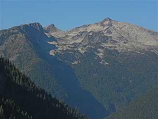
Hidden Lake Peaks is series of peaks with a maximum elevation of 7,088 feet that are located in the North Cascades, in Skagit County of Washington state. The peaks extend three miles southwest from the nearest higher peak called The Triad. Situated on the western boundary of North Cascades National Park, Hidden Lake Peaks are positioned west of the crest of the Cascade Range, approximately ten miles east of the town of Marblemount. The popular subsidiary peak, Hidden Lake Lookout (6890 ft), lies a half mile to the southwest of the highest summit. The mountain's name is taken from its proximity to Hidden Lake which lies in a cirque below the east aspect of these two main peaks. Precipitation runoff from Hidden Lake Peaks drains into Cascade River which is a tributary of the Skagit River.


