Proclamation Day commonly refers to the anniversary of the proclamation of government of the province of South Australia, which continues to be celebrated in South Australia on 28 December, although no longer a public holiday. The anniversary of the establishment of self-government on 21 October 1890 was formerly known as Proclamation Day in Western Australia.
The Division of Hindmarsh is an Australian Electoral Division in South Australia covering the north western and western coastal suburbs of Adelaide. The division was one of the seven established when the former Division of South Australia was split on 2 October 1903, and was first contested at the 1903 election, though now on slightly different boundaries. The Division is named after Sir John Hindmarsh, who was Governor of South Australia from 1836 to 1838. Since the 2019 Australian federal election The Division of Hindmarsh consists of part of the City of Charles Sturt, part of the City of Port Adelaide Enfield, and part of the City of West Torrens.

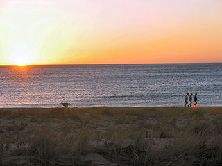
Glenelg is a beach-side suburb of the South Australian capital of Adelaide. Located on the shore of Holdfast Bay in Gulf St Vincent, it has become a tourist destination due to its beach and many attractions, home to several hotels and dozens of restaurants.

Rear-Admiral Sir John Hindmarsh KH was a naval officer and the first Governor of South Australia, from 28 December 1836 to 16 July 1838.
Glengowrie is a suburb of the Australian city of Adelaide, approximately 12 kilometres south west of the city centre. The name Glengowrie means "Glen of Gowrie", so called in honour of Lord Gowrie, Governor-General of Australia from 1936 to 1944.
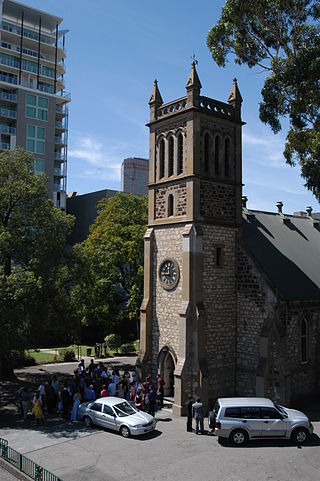
Trinity Church Adelaide, formerly known as Holy Trinity Church and later Trinity City, is an Australian evangelical Anglican church located at 88 North Terrace in the city of Adelaide, South Australia. Established in 1836, it is one of the earliest churches in the colony of South Australia.
Plympton is an inner south-western suburb of Adelaide, South Australia. The name is believed to have been given by Henry Mooringe Boswarva to a private subdivision in the area, naming after his home town in Devon, England. It was accepted as an official name for the suburb in 1944.

Thebarton, formerly Theberton, on Kaurna land, is an inner-western suburb of Adelaide, South Australia in the City of West Torrens. The suburb is bounded by the River Torrens to the north, Port Road and Bonython Park to the east, Kintore Street to the south, and South Road to the west.
The City of West Torrens is a local government area in the western suburbs of Adelaide, South Australia. Since the 1970s, the area was mainly home to many open spaces and parks, however after the mid-1990s (1993–1995) the LGA became more residential.

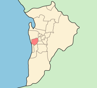
The City of Holdfast Bay is a local government area in the south-western coastal suburbs of Adelaide, South Australia.

Government House, located in Adelaide on the corner of North Terrace and King William Road, is the official residence of the governor of South Australia.
Moseley Square is a public square in the City of Holdfast Bay at Glenelg, and was named for Henry J. Moseley, the builder and first publican of the Pier Hotel, Glenelg. Located between Jetty Road and Glenelg Beach, the Square is the location of the Glenelg Town Hall, Glenelg Jetty, the Stamford Grand Hotel and various fast-food outlets. It is the terminus of the Glenelg tram line from Adelaide. It is a site of major events including the Glenelg Jazz Festival and the City to Bay Fun Run.

Anzac Highway is an 8.7-kilometre-long (5.4 mi) main arterial road heading southwest from the city of Adelaide, the capital of South Australia, to the beachside suburb of Glenelg.
Seacliff is a coastal suburb located in the capital city of South Australia; Adelaide. Overseen by the council, City of Holdfast Bay, this suburb is adjacent to South Brighton, Seacliff Park, Marino and Kingston Park.

Glenelg North is a seaside suburb of Adelaide, South Australia. It is located in both the City of Holdfast Bay and the City of West Torrens.

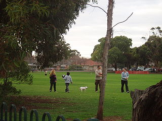
Holdfast Bay is a small bay in Gulf St Vincent, next to Adelaide, South Australia. Along its shores lie the local government area of the City of Holdfast Bay and the suburbs of Glenelg and Glenelg North The colonial settlement at Holdfast Bay was the first seat of government of South Australia.

Glenelg East is a residential suburb 9 kilometres (5.6 mi) south-west of the centre of Adelaide, South Australia. It is characterised by quarter-acre blocks with heritage homes and parks intermingled with contemporary modern homes and low-rise multi-dwelling units.

The Patawalonga River is a river located in the western suburbs of the Adelaide metropolitan area, in the Australian state of South Australia. It drains an area of flat, swampy lands formerly known as the Cowandilla Plains or The Reedbeds, which in the mid-20th century were drained by engineering works, enabling the establishment of Adelaide Airport and the development of residential housing.
Gower Conservation Park is a protected area located in the Australian state of South Australia in the locality of Tantanoola about 353 kilometres (219 mi) south-east of the state capital of Adelaide and about 25 kilometres (16 mi) north west of the regional city of Mount Gambier.
The Pier Hotel was a public inn in Glenelg in the British colony, then Australian state, of South Australia.


 Old Gum Tree in 1867
 The Old Gum Tree, 1936
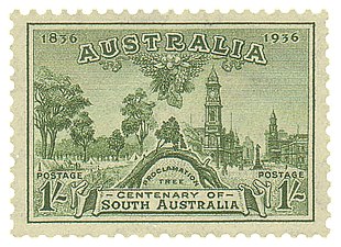 Postage stamp, Australia, 1936
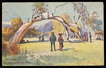 Postcard from 1903


