Related Research Articles
The Kaurna people are a group of Aboriginal people whose traditional lands include the Adelaide Plains of South Australia. They were known as the Adelaide tribe by the early settlers. Kaurna culture and language were almost completely destroyed within a few decades of the British colonisation of South Australia in 1836. However, extensive documentation by early missionaries and other researchers has enabled a modern revival of both language and culture. The phrase Kaurna meyunna means "Kaurna people".

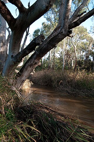
The River Torrens, is the most significant river of the Adelaide Plains. It was one of the main reasons for the siting of the city of Adelaide, capital of South Australia. It flows 85 kilometres (53 mi) from its source in the Adelaide Hills near Mount Pleasant, across the Adelaide Plains, past the city centre and empties into Gulf St Vincent between Henley Beach South and West Beach. The upper stretches of the river and the reservoirs in its watershed supply a significant part of the city's water supply.

Gulf St Vincent, sometimes referred to as St Vincent Gulf, St Vincent's Gulf or Gulf of St Vincent, is the eastern of two large inlets of water on the southern coast of Australia, in the state of South Australia, the other being the larger Spencer Gulf, from which it is separated by Yorke Peninsula. On its eastern side the gulf is bordered by the Adelaide Plains and the Fleurieu Peninsula.

The Port River is part of a tidal estuary located north of the Adelaide city centre in the Australian state of South Australia. It has been used as a shipping channel since the beginning of European settlement of South Australia in 1836, when Colonel Light selected the site to use as a port. Before colonisation, the Port River region and the estuary area were known as Yerta Bulti by the Kaurna people, and used extensively as a source of food and plant materials to fashion artefacts used in daily life.

This article details the History of Adelaide from the first human activity in the region to the 20th century. Adelaide is a planned city founded in 1836 and the capital of South Australia.

The Adelaide Park Lands comprise the figure-eight configuration of land, spanning both banks of the River Torrens between Hackney and Thebarton, which encloses and separates the City of Adelaide area from the surrounding suburbia of greater metropolitan Adelaide, the capital city of South Australia. They were laid out by Colonel William Light in his design for the city, and originally consisted of 2,300 acres (930 ha) "exclusive of 32 acres (13 ha) for a public cemetery". One copy of Light's plan shows areas for a cemetery and a Post and Telegraph Store on West Terrace, a small Government Domain and Barracks on the central part of North Terrace, a hospital on East Terrace, a Botanical Garden on the River Torrens west of North Adelaide, and a school and a storehouse south-west of North Adelaide.

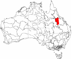
The Adelaide Plains is a plain in South Australia lying between the coast on the west and the Mount Lofty Ranges on the east. The southernmost tip of the plain is in the southern seaside suburbs of Adelaide around Brighton at the foot of the O'Halloran Hill escarpment with the south Hummocks Range and Wakefield River roughly approximating the northern boundary.

Bonython Park is a 17-hectare park in the north-west Park Lands of the South Australian capital of Adelaide. The park was opened in 1962 and named in honour of prominent South Australian politician and journalist, Sir John Langdon Bonython. It is situated on north-western side of the River Torrens, bordered by Port Road. It is on the opposite side of the river to a golf course, and adjacent to the old Adelaide Gaol and the Police Barracks.
Kaurna is a Pama-Nyungan language historically spoken by the Kaurna peoples of the Adelaide Plains of South Australia. The Kaurna peoples are made up of various tribal clan groups, each with their own parnkarra district of land and local dialect. These dialects were historically spoken in the area bounded by Crystal Brook and Clare in the north, Cape Jervis in the south, and just over the Mount Lofty Ranges. Kaurna ceased to be spoken on an everyday basis in the 19th century and the last known native speaker, Ivaritji, died in 1929. Language revival efforts began in the 1980s, with the language now frequently used for ceremonial purposes, such as dual naming and welcome to country ceremonies.
Warriparinga, also spelt Warriparingga, is a nature reserve comprising 3.5 hectares in the metropolitan suburb of Bedford Park, in the southern suburbs of Adelaide, South Australia. Also known as Fairford, Laffer's Triangle and the Sturt Triangle, Warriparinga is bordered by Marion Road, Sturt Road and South Road, and is traversed by the Sturt River as it exists from Sturt Gorge to travel west across the Adelaide Plains.
Cowandilla is a western suburb in Adelaide, South Australia, in the City of West Torrens. It is located a few kilometres west of the CBD, close to Adelaide Airport. Sir Donald Bradman Drive crosses the middle of the suburb.

Fulham is a western suburb of Adelaide, South Australia. It is located in the City of West Torrens.

Adelaide city centre is the inner city locality of Greater Adelaide, the capital city of South Australia. It is known by locals simply as "the City" or "Town" to distinguish it from Greater Adelaide and from the City of Adelaide local government area. The population was 15,115 in the 2016 census.

The Patawalonga River is a river located in the western suburbs of the Adelaide metropolitan area, in the Australian state of South Australia. It drains an area of flat, swampy lands formerly known as the Cowandilla Plains or The Reedbeds, which in the mid-20th century were drained by engineering works, enabling the establishment of Adelaide Airport and the development of residential housing.
The Sturt River, also known as the Sturt Creek and Warri Parri (Warriparri) in the Kaurna language, is a river located in the Adelaide region of the Australian state of South Australia.
The District Council of Yatala was a local government area of South Australia established in 1853 and abolished in 1868.
The Desert Uplands is an interim Australian bioregion located in north and central western Queensland which straddles the Great Dividing Range between Blackall and Pentland.

Aldinga Scrub Conservation Park is a protected area in the Australian state of South Australia located in the suburb of Aldinga Beach about 46 kilometres south by west of the state capital of Adelaide.

The Hundred of Yatala is a cadastral unit of hundred in South Australia covering much of the Adelaide metropolitan area north of the River Torrens. It is one of the eleven hundreds of the County of Adelaide stretching from the Torrens in the south to the Little Para River in the north; and spanning from the coast in the west to the Adelaide foothills in the east. It is roughly bisected from east to west by Dry Creek. It was named in 1846 by Governor Frederick Robe, Yatala being likely derived from yartala, a Kaurna word referring to the flooded state of the plain either side of Dry Creek after heavy rain.
William Henry Gray, generally known as W. H. Gray, was a pioneer colonist of South Australia who amassed considerable wealth through ownership and development of land.
References
- ↑ Holmes, J. W. & Iversen, M. B. (1976). "Hydrology of the Cowandilla Plains, Adelaide, before 1836". In Twidale, C. R.; Tyler, M. J. & Webb, B. P. (eds.). Natural History of the Adelaide Region. Royal Society of South Australia Inc. ISBN 0-9596627-3-1.
- ↑ Holmes, J. W. & Iversen, M. B. (1976). "Hydrology of the Cowandilla Plains, Adelaide, before 1836". In Twidale, C. R.; Tyler, M. J. & Webb, B. P. (eds.). Natural History of the Adelaide Region. Royal Society of South Australia Inc. ISBN 0-9596627-3-1.
- ↑ Hasenohr, E. (1977). W. H. Gray – A Pioneer Colonist of South Australia. Adelaide. ISBN 0-9596673-0-X.
- ↑ "Witongga "Reed Place" (Reedbeds)". www.charlessturt.sa.gov.au. 26 August 2019. Retrieved 7 May 2021.
- ↑ Linn, Rob. (1989): Nature's Pilgrim. The life and journeys of Captain S. A. White, naturalist, author and conservationist. SA Government Printer: Adelaide. ISBN 0724365486
- ↑ "Advertising". South Australian Register . Vol. XLII, no. 9656. South Australia. 25 October 1877. p. 8. Retrieved 3 March 2019– via National Library of Australia.