The Metropolitan Borough of Bolton is a metropolitan borough in Greater Manchester, England, named after its largest town, Bolton, but covering a larger area which includes Blackrod, Farnworth, Horwich, Kearsley, Westhoughton, and part of the West Pennine Moors. It had a population of 298,903 in 2022, making it the third-most populous district in Greater Manchester.

Farnworth is a town in the Metropolitan Borough of Bolton, Greater Manchester, England, 2 miles (3.2 km) southeast of Bolton, 4 miles south-west of Bury (7 km), and 8 miles (12.9 km) northwest of Manchester.

Ye Olde Fighting Cocks is a pub in St Albans, Hertfordshire, England. It is one of several pubs that lay claim to being the oldest in England, claiming to have been in business since 793 AD. Its claim to that date is somewhat uncertain: the building is described by Historic England as being of 16th-century appearance, and the earliest date for which it might have been licensed is 1756. Other pubs such as Ye Olde Man & Scythe in Bolton, Greater Manchester, and Ye Olde Trip to Jerusalem in Nottingham also make unproved claims to being the oldest. Ye Olde Fighting Cocks was once listed as the oldest in England by the Guinness World Records, but the record was withdrawn from consideration in 2000 because it was deemed impossible to verify.

Rowarth is a hamlet about 2.5 miles (4 km) north of New Mills in the High Peak borough of Derbyshire, England. It is on the edge of the Peak District, in the hills between New Mills and Marple Bridge, within the parish boundary of New Mills.

Great Lever is a suburb of Bolton, Greater Manchester, England. Historically in Lancashire, it is 2+1⁄2 miles (4.0 km) south of Bolton town centre and the same distance north of Farnworth. The district is served by frequent buses running to Bolton town centre, Farnworth and the Royal Bolton Hospital. The population is 16,969.

Deane is an area of Bolton, in Greater Manchester, England. It is about 2 miles (3.2 km) south west of Bolton and 11 miles (17.7 km) northwest of Manchester.

Bradshaw Gass & Hope is an English architectural practice founded in 1862 by Jonas James Bradshaw. It is Bolton's oldest architectural practice and has exhibited archive drawings in London and Manchester. The style "Bradshaw Gass & Hope" was adopted after Bradshaw's death to incorporate the names of the remaining partners, John Bradshaw Gass and Arthur John Hope. As of 2022, the firm continues to operate from offices in Bolton.
St Saviour's Church is in Ringley, Kearsley, near Bolton, Greater Manchester, England. It is an active Anglican parish church in the deanery of Bolton, the archdeaconry of Bolton and the diocese of Manchester. Its benefice is united with those of St Peter's, Farnworth, St John the Evangelist, Farnworth and Holy Trinity, Prestolee. The church is recorded in the National Heritage List for England as a designated Grade II listed building.
Bolton Council, or Bolton Metropolitan Borough Council, is the local authority of the Metropolitan Borough of Bolton in Greater Manchester, England. It is a metropolitan borough council and provides the majority of local government services in the borough. The council has been a member of the Greater Manchester Combined Authority since 2011.

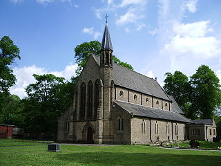
St John the Evangelist's Church is in Church Street, Farnworth, Greater Manchester, England. It is an active Anglican parish church in the deanery of Bolton, the archdeaconry of Bolton, and the diocese of Manchester. Its benefice is united with those of St Peter, Farnworth, Holy Trinity, Prestolee, and St Saviour, Ringley. The church is recorded in the National Heritage List for England as a designated Grade II listed building.

Woodbank is a historical villa and park in Stockport, Greater Manchester, England. The surrounding park, east of Vernon Park, is known as Woodbank Memorial Park and covers approximately 49 acres (20 ha).

The White Lion is a public house in Barthomley, Cheshire, England, just off junction 16 of the M6. It was built in 1614, and is recorded in the National Heritage List for England as a designated Grade II* listed building.
The Railway is a Grade II listed pub in Altrincham, Greater Manchester, England.

The Old White Lion is a Grade II listed pub in Bury, Greater Manchester, England.
The Grapes is a Grade II listed pub in Eccles, Salford, England.

The Stanley Arms is a Grade II listed pub in Eccles, Salford, England.

The Plough is a Grade II listed pub in the Gorton area of Manchester, England.

The Briton's Protection is a historic, Grade II listed public house in Manchester, England. Various dates are given for its establishment; the pub's own website says 1806, although its bicentenary was not celebrated until 2011. It was listed in Pigot and Dean's New Directory of Manchester & Salford for 1821 and 1822.
Farnworth is a town and an unparished area in the Metropolitan Borough of Bolton, Greater Manchester, England. It contains 14 listed buildings that are recorded in the National Heritage List for England. All the listed buildings are designated at Grade II, the lowest of the three grades, which is applied to "buildings of national importance and special interest". The area is mainly residential, and the listed buildings include churches and associated structures, two former cotton mills, a railway bridge and a tunnel, a former toll house, a public library, a town hall, a former country house, a war memorial, and a public house.
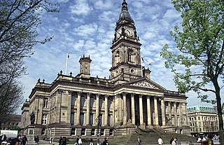
Farnworth Town Hall is a municipal building in Market Street, Farnworth, Greater Manchester, England. The town hall, which was the headquarters of Farnworth Borough Council, is a grade II listed building.

