Hope Bay is a bay 3 nautical miles long and 2 nautical miles wide, indenting the tip of the Antarctic Peninsula and opening on Antarctic Sound.

The Fildes Peninsula is a 7 km (4.3 mi) long peninsula that forms the south-western end of King George Island in the South Shetland Islands of Antarctica. It was named from association with nearby Fildes Strait by the UK Antarctic Place-Names Committee in 1960; the strait was likely named for Robert Fildes, a British sealer of the 1800s.

Admiralty Bay is an irregular bay, 8 km (5 mi) wide at its entrance between Demay Point and Martins Head, indenting the southern coast of King George Island for 16 km (10 mi), in the South Shetland Islands of Antarctica. The name appears on a map of 1822 by Captain George Powell, a British sailor, and is now established in international usage. The Henryk Arctowski Polish Antarctic Station is situated on the bay, as is the Comandante Ferraz Brazilian Antarctic Base. It has been designated an Antarctic Specially Managed Area.

Cape Shirreff is a prominent cape at the north end of the rocky peninsula which separates Hero Bay and Barclay Bay on the north coast of Livingston Island, in the South Shetland Islands of Antarctica. The cape was named by Edward Bransfield in 1820 after Captain William H. Shirreff, the British commanding officer in the Pacific at that time.

Yankee Harbour is a small inner harbour entered from Shopski Cove between Glacier Bluff and Spit Point, indenting the south-west side of Greenwich Island in the South Shetland Islands, Antarctica. It is 2.35 km (1.46 mi) long in west-south-west to east-north-east direction, and 1.6 km (0.99 mi) wide, and is bounded by Provadiya Hook to the south-west, Parvomay Neck to the north and east, and Kladara Beach to the south.

Byers Peninsula is a mainly ice-free peninsula forming the west end of Livingston Island in the South Shetland Islands of Antarctica. It occupies 60 km2 (23 sq mi), borders Ivanov Beach to the northeast and is separated from Rotch Dome on the east by the ridge of Urvich Wall. The peninsula features more than 60 meltwater streams and as many lakes, notably Midge Lake, Limnopolar Lake and Basalt Lake. Byers Peninsula has a regime of special environmental protection under the Antarctic Treaty System and requires a permit to enter.
Devils Point is a point marking the southwest extremity of Byers Peninsula, Livingston Island in the South Shetland Islands, Antarctica and forming the southeast side of the entrance to Osogovo Bay and the west side of the entrance to Raskuporis Cove. The point is separated from Vardim Rocks to the south by Hell Gates. Lucifer Crags, a rocky bluff rising to 81 m at the south extremity of President Beaches, surmount Devils Point on the southwest, Acheron Lake on the northeast and Siren Lake on the east-southeast. The area was visited by early 19th century sealers.
Essex Point is a point at the northwest end of Byers Peninsula, Livingston Island in the South Shetland Islands, Antarctica. It forms the west side of the entrance to Barclay Bay and the northeast side of the entrance to Svishtov Cove, and is surmounted by Drong Hill.

Coppermine Peninsula is the rugged, rocky promontory forming the northwest extremity of Alfatar Peninsula and Robert Island in the South Shetland Islands, Antarctica. It lies between the English Strait to the west and Carlota Cove to the east. It is 1.7 km long, 500 m wide and rising to 105 m.
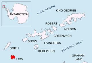
Jameson Point is a small headland on the north side of the entrance to Malina Cove, situated 6.3 km (3.9 mi) north of Cape Garry on the west side of Low Island, in the South Shetland Islands of Antarctica. It was roughly charted by the French Antarctic Expedition, 1908–10. The point was photographed from the air by the Falkland Islands and Dependencies Aerial Survey Expedition, 1955–57, and more accurately delineated from these photos by the Falkland Islands Dependencies Survey in 1959. The name "Jameson Island" was applied to Low Island by James Weddell in 1820–23, and Jameson Point has been approved for this point to preserve Weddell's name on Low Island.
Suffield Point is the south-west entrance point of Norma Cove, Fildes Peninsula, on King George Island in the South Shetland Islands of Antarctica. It was charted in the course of the Discovery Investigations, 1933–35, and named after boatswain William E. Suffield. The site is part of the Fildes Peninsula Antarctic Specially Protected Area, designated as such because of its paleontological values.
Potter Peninsula is a low ice-free peninsula between Potter Cove and Stranger Point in south-west King George Island, in the South Shetland Islands of Antarctica. It is protected as ASPA 132, largely because of the richness and diversity of its flora and fauna.

Harmony Point is a point which lies close west of Harmony Cove and forms both the south side of the entrance to Malak Sechko Cove and the western extremity of Guangzhou Peninsula and Nelson Island, in the South Shetland Islands of Antarctica. It was charted in 1935 by Discovery Investigations personnel on the Discovery II, and named from association with Harmony Cove.
Ross Point is a point forming the southeast side of the entrance to Varvara Cove on the southwest side of Nelson Island in the South Shetland Islands, situated 7.85 km southeast of Harmony Point. The point was charted by DI personnel on the Discovery II in 1935.
Harmony Cove is a cove entered between Harmony Point and The Toe on the west side of Nelson Island, in the South Shetland Islands, Antarctica. It was named by American sealers in about 1820 after the sealing vessel Harmony, under Captain Thomas Ray, one of several American sealing vessels headquartered at Harmony Cove during the 1820–21 season.

The Cierva Point and offshore islands Important Bird Area is a 6540 ha tract of land and sea on the Danco Coast of the Antarctic Peninsula.
Smilets Point is the rocky point on the southwest side of the entrance to Hall Cove, at the northeast end of Lambreva Beach, projecting 500 m north-northwestwards from the northwest coast of Nelson Island in the South Shetland Islands, Antarctica. The area was visited by early 19th century sealers.
Retamales Point is the rock-tipped northeast entrance point of Hall Cove and west entrance point of Argonavt Cove, projecting 700 m northwards from the northwest coast of Nelson Island in the South Shetland Islands, Antarctica. The area was visited by early 19th century sealers.
Guangzhou Peninsula is the mostly ice-free peninsula forming the west extremity of Nelson Island in the South Shetland Islands, Antarctica and ending up in Harmony Point. It is bounded by Harmony Cove and Nelson Strait on the south and southwest, and Malak Sechko Cove and Golyam Sechko Cove in Drake Passage on the northwest, extends 3.4 km in northeast–southwest direction and 2.7 km in southeast–northwest direction, and has a surface area of 5.02 km2. The area was visited by early 19th century sealers based at Harmony Cove.
Frisius Point is the rocky north entrance point of Malak Sechko Cove and southwest entrance point of Golyam Sechko Cove projecting 450 m westwards from the northwest coast of Guangzhou Peninsula on Nelson Island in the South Shetland Islands, Antarctica. The area was visited by early 19th century sealers. Frisius Point is part of both Antarctic Specially Protected Area Harmony Point and the BirdLife International Important Bird Area Harmony Point, Nelson Island.
