
Hoover Dam is a concrete arch-gravity dam in the Black Canyon of the Colorado River, on the border between the U.S. states of Nevada and Arizona. Constructed between 1931 and 1936, during the Great Depression, it was dedicated on September 30, 1935, by President Franklin D. Roosevelt. Its construction was the result of a massive effort involving thousands of workers, and cost over 100 lives. In bills passed by Congress during its construction, it was referred to as the Hoover Dam, after President Herbert Hoover, but was named the Boulder Dam by the Roosevelt administration. In 1947, the name Hoover Dam was restored by Congress.

Glen Canyon Dam is a concrete arch-gravity dam in the southwestern United States, located on the Colorado River in northern Arizona, near the city of Page. The 710-foot-high (220 m) dam was built by the Bureau of Reclamation (USBR) from 1956 to 1966 and forms Lake Powell, one of the largest man-made reservoirs in the U.S. with a capacity of more than 25 million acre-feet (31 km3). The dam is named for Glen Canyon, a series of deep sandstone gorges now flooded by the reservoir; Lake Powell is named for John Wesley Powell, who in 1869 led the first expedition to traverse the Colorado River's Grand Canyon by boat.

Grand Coulee Dam is a concrete gravity dam on the Columbia River in the U.S. state of Washington, built to produce hydroelectric power and provide irrigation water. Constructed between 1933 and 1942, Grand Coulee originally had two powerhouses. The third powerhouse ("Nat"), completed in 1974 to increase energy production, makes Grand Coulee the largest power station in the United States by nameplate capacity at 6,809 MW.
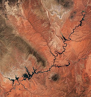
Lake Powell is a reservoir on the Colorado River in Utah and Arizona, United States. It is a major vacation destination visited by approximately two million people every year. It holds 24,322,000 acre-feet (3.0001×10¹⁰ m3) of water when full, second in the United States to only Lake Mead - though Lake Mead has fallen below Lake Powell in size several times during the 21st century in terms of volume of water, depth and surface area.

The Salt River is a river in Gila and Maricopa counties in Arizona, United States, that is the largest tributary of the Gila River. The river is about 200 miles (320 km) long. Its drainage basin covers about 13,700 square miles (35,000 km2). The longest of the Salt River's many tributaries is the 195-mile (314 km) Verde River. The Salt's headwaters tributaries, the Black River and East Fork, increase the river's total length to about 300 miles (480 km). The name Salt River comes from the river's course over large salt deposits shortly after the merging of the White and Black Rivers.

Davis Dam is a dam on the Colorado River about 70 miles (110 km) downstream from Hoover Dam. It stretches across the border between Arizona and Nevada. Originally called Bullhead Dam, Davis Dam was renamed after Arthur Powell Davis, who was the director of the U.S. Bureau of Reclamation from 1914 to 1923. The United States Bureau of Reclamation owns and operates the dam, which was completed in 1951.

The Apache Trail in Arizona was a stagecoach trail that ran through the Superstition Mountains. It was named the Apache Trail after the Apache Indians who originally used this trail to move through the Superstition Mountains.
The Salt River Project (SRP) encompasses two separate entities: the Salt River Project Agricultural Improvement and Power District, an agency of the state of Arizona that serves as an electrical utility for the Phoenix metropolitan area, and the Salt River Valley Water Users' Association, a utility cooperative that serves as the primary water provider for much of central Arizona. It is one of the primary public utility companies in Arizona.

The Mike O'Callaghan–Pat Tillman Memorial Bridge is an arch bridge in the United States that spans the Colorado River between the states of Arizona and Nevada. The bridge is located within the Lake Mead National Recreation Area approximately 30 miles (48 km) southeast of Las Vegas, and carries Interstate 11 and U.S. Route 93 over the Colorado River. Opened in 2010, it was the key component of the Hoover Dam Bypass project, which rerouted US 93 from its previous routing along the top of Hoover Dam and removed several hairpin turns and blind curves from the route. It is jointly named for Mike O'Callaghan, Governor of Nevada from 1971 to 1979, and Pat Tillman, an American football player who left his career with the Arizona Cardinals to enlist in the United States Army and was killed in Afghanistan in 2004 by friendly fire.
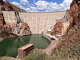
Theodore Roosevelt Dam is a dam on the Salt River located northeast of Phoenix, Arizona. The dam is 357 feet (109 m) high and forms Theodore Roosevelt Lake as it impounds the Salt River. Built between 1905 and 1911, the dam was renovated and expanded in 1989–1996. The dam is named after President Theodore Roosevelt. Serving mainly for irrigation, water supply, and flood control, the dam also has a hydroelectric generating capacity of 36 megawatts.

The Glen Canyon Bridge or Glen Canyon Dam Bridge is a steel arch bridge in Coconino County, Arizona, carrying U.S. Route 89 across the Colorado River. The bridge was originally built by the United States Bureau of Reclamation to facilitate transportation of materials for the Glen Canyon Dam, which lies adjacent to the bridge just 865 feet (264 m) upstream. The two-lane bridge has an overall length of 1,271 feet (387 m) with a deck 700 feet (210 m) above the river, making it one of the highest bridges in the United States. The bridge was the highest arch bridge in the world when completed in 1959.
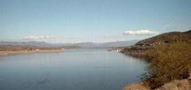
Theodore Roosevelt Lake is a large reservoir formed by Theodore Roosevelt Dam on the Salt River in Arizona as part of the Salt River Project (SRP). Located roughly 80 miles (130 km) northeast of Phoenix in the Salt River Valley, Theodore Roosevelt is the largest lake or reservoir located entirely within the state of Arizona. The reservoir and the masonry dam that created it, Roosevelt Dam, were both named after U.S. President Theodore Roosevelt who dedicated the dam himself on March 18, 1911. Roosevelt Lake is a popular recreation destination within the Tonto National Forest; the facilities located at this lake are managed by that authority.

The Bartlett Dam is a concrete multiple-arch buttress dam on the Verde River, located 50 km northeast of Phoenix, Arizona. The dam creates Bartlett Lake and its primary purpose is irrigation water supply. It was the first dam constructed on the Verde River and the first of its type constructed by the U.S. Bureau of Reclamation. It was built between 1936 and 1939. It was named after Bill Bartlett, a government surveyor. It was listed on the National Register of Historic Places in 2017.

The Colorado River Storage Project is a United States Bureau of Reclamation project designed to oversee the development of the upper basin of the Colorado River. The project provides hydroelectric power, flood control and water storage for participating states along the upper portion of the Colorado River and its major tributaries.
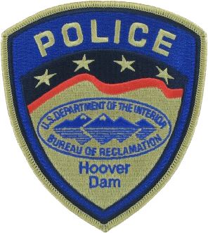
The Hoover Dam Police, officially the Bureau of Reclamation Police, was a federal security police force, stationed at Hoover Dam 23 miles (37 km) southeast of Las Vegas under the command of the US Bureau of Reclamation. Reclamation Police Officers were stationed only at Hoover Dam. Hoover Dam was both listed on the National Register of Historic Places in 1981, and was designated a National Historic Landmark in 1985. Hoover Dam has been designated as National Critical Infrastructure. The primary responsibilities of the Hoover Dam Police Officer were to protect the dam, the world's 57th-largest hydroelectric generating station, which provides about 2,080 megawatts, its associated structures, and to safeguard the lives of visitors and employees. The Hoover Dam Police were assisted by unarmed Bureau of Reclamation Security Guards who control access to reclamation facilities and deter individuals who might consider criminal activities or terrorist acts.

The Kettle Falls Bridges is the collective name for a pair of steel cantilever bridges carrying State Route 20/U.S. Route 395 and the Kettle Falls International Railway across the Columbia River at Kettle Falls, Washington. The south bridge carries motor vehicle traffic while the similar northern span is used for rail.
Roosevelt is a census-designated place (CDP) in Gila County, Arizona, United States. The population was 28 at the 2010 census.

Lake Tahoe Dam is a concrete gravity dam on the Truckee River, at the outlet of Lake Tahoe in Placer County, California.

