
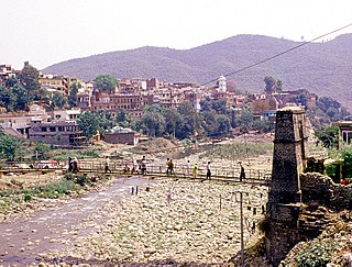
Bhimber District is a district of Pakistan-administered Azad Kashmir in the disputed Kashmir region. It is the southernmost district of the 10 districts of Pakistan's dependent territory of Azad Kashmir. It has an area of 1516 km², and the district headquarter is the town of Bhimber.

Bhaderwah or Bhadarwah is a town, tehsil, sub-division and also additional district in the Doda district of the Jammu Division of Jammu and Kashmir, India. It is also known as Chota Kashmir for its scenic beauty and for its high literacy rate it is known as Kerala of Jammu and Kashmir.

Poonch or Punch is a district of the Jammu division of Indian-administered Jammu and Kashmir in the disputed Kashmir region. With headquarters in the town of Poonch, it is bounded by the Line of Control on three sides. The 1947-48 war between India and Pakistan divided the earlier district into two parts. One went to Pakistan and the other became part of the then-Indian state of Jammu and Kashmir.

Rajouri or Rajpur is a district in the Jammu division of Indian-administered Jammu and Kashmir in the disputed Kashmir region. The Line of Control lies to its west, Poonch to its north, the Reasi district to the east and the Jammu district to its south. Rajouri is famous for its "Kalari". Representing an ancient principality, Rajouri was a joint district, along with Reasi, at the time of princely state's accession to India in 1947. The two tehsils were separated and Rajouri was merged with the Poonch district. Rajouri again became a separate district in 1968.
Nowshera is a town and the headquarters of an eponymous tehsil of Rajouri district in the Jammu division of the Indian Union Territory of Jammu and Kashmir. It is governed by a Municipal committee and in rural area of Nowshera consists of 14 panchayats governed by local bodies under the supervision of district administration Rajouri.
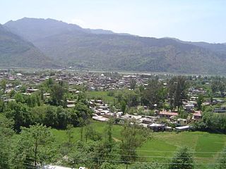
Rajouri or Rajpur is a city in the Rajouri district of Jammu and Kashmir. It is located about 155 kilometres (96 mi) from Srinagar and 150 km (93 mi) from Jammu city on the Poonch Highway. The city is the location of the birthplace of Sadhu turned Sikh General Banda Singh Bahadur. Baba Ghulam Shah Badshah University is also situated in this district.

Reasi is a town and a notified area committee and tehsil in Reasi district of the Indian union territory of Jammu and Kashmir. Situated on the bank of River Chenab, It is the headquarters of the Reasi district. In the eighth century, Reasi was a part of the Bhimgarh state established by Rajput king Bhim Dev Rasyal. The name Reasi is derived from the town's old name, "Rasyal".
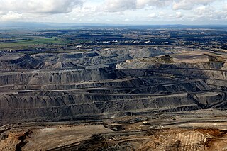
Coal is mined in every state of Australia. The largest black coal resources occur in Queensland and New South Wales. About 70% of coal mined in Australia is exported, mostly to eastern Asia, and of the balance most is used in electricity generation. In 2019-20 Australia exported 390 Mt of coal and was the world's largest exporter of metallurgical coal and second largest exporter of thermal coal.

Reasi district is an administrative district in the Jammu division of Indian-administered Jammu and Kashmir in the disputed Kashmir region. The Reasi district is bordered by Udhampur district and Ramban district in the east, Jammu district in the south, Rajouri district in the west and by Kulgam district on the north. The Reasi and Rajouri tehsils formed a joint district called the "Reasi district" at the time of princely state's accession to India in 1947. As part of the reorganisation, the two tehsils were separated and Reasi was merged with the Udhampur district. It again became a separate district in 2006.

Kishtwar district is an administrative district of the Jammu division of Indian-administered Jammu and Kashmir in the disputed Kashmir region. As of 2011, it is the largest and the least populous district of Jammu and Kashmir.

Masud Choudhary was an Indian educator, social reformer, thinker and an administrator of Jammu and Kashmir union territory. He was the founding Vice Chancellor of Baba Ghulam Shah Badshah University in Rajouri, J&K. He was also the Chief Patron of the Gurjar Desh Charitable Trust.
The Haveli Tehsil is a tehsil of the Poonch district in the Indian union territory of Jammu and Kashmir. It is headquartered at the Poonch Town.
Korba Coalfield is located in Korba district in the Indian state of Chhattisgarh in the basin of the Hasdeo River, a tributary of the Mahanadi.

Thathri is a town and a notified area committee in Doda district in the Indian union territory of Jammu and Kashmir. Thathri valley is located in the foothills of the Himalayan mountains, about 85 km from Batote. Apart from having ample forests, the town contains many small streams flowing through its various parts. It is located on the banks of the Chenab River and the town area is spread over 1.50 sq. Km².
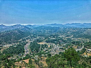
Kalakote is a town located in Rajouri district of Jammu region in the Indian union territory of Jammu and Kashmir. Kalakote is noted for its coal mines and has first Thermal Power Plant of North India. There is also a tehsil, sub division, block, municipal committee and constituency with this name and each of these has its headquarters in Kalakot town.

Jammu and Kashmir is a region administered by India as a union territory and consists of the southern portion of the larger Kashmir region, which has been the subject of a dispute between India and Pakistan since 1947 and between India and China since 1959. The Line of Control separates Jammu and Kashmir from the Pakistani-administered territories of Azad Kashmir and Gilgit-Baltistan in the west and north. It lies to the north of the Indian states of Himachal Pradesh and Punjab and to the west of Ladakh which is administered by India as a union territory.
Sialsui is a village in Rajouri district of the Indian union territory of Jammu and Kashmir in India. As per Census 2011 report, the location code or village code of Sialsui village is 001507. It is located 20 km towards the South from Rajouri, which is the district and 15 km away from the sub-district headquarter Kalakote of Sialsui village.
Panjah is one of 69 villages of tehsil Kalakote of Rajouri district of Jammu region in the Indian union territory of Jammu and Kashmir.
Government Degree College Kalakote is a government run educational college located in the Kalakote town of Rajouri district in the Indian union territory of Jammu and Kashmir. It is affiliated with Jammu University and is recognised by the University Grants Commission.
Tatta Pani is village with a natural hot water sulfur spring located in the Kalakote tehsil of Rajouri district in the Indian union territory of Jammu and Kashmir. The hot spring is situated near the Pir Panjal Range and is approximately 14 km (8.7 mi) kilometers away from Kalakote.
