A solar equinox is a moment in time when the Sun crosses the Earth's equator, which is to say, appears directly above the equator, rather than north or south of the equator. On the day of the equinox, the Sun appears to rise "due east" and set "due west". This occurs twice each year, around 20 March and 23 September.

The Northern Hemisphere is the half of Earth that is north of the Equator. For other planets in the Solar System, north is defined as being in the same celestial hemisphere relative to the invariable plane of the Solar System as Earth's North Pole.
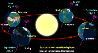
A solstice is the time when the Sun reaches its most northerly or southerly excursion relative to the celestial equator on the celestial sphere. Two solstices occur annually, around June 20–22 and December 20–22. In many countries, the seasons of the year are determined by the solstices and the equinoxes.

A geographic coordinate system (GCS) is a spherical or geodetic coordinate system for measuring and communicating positions directly on Earth as latitude and longitude. It is the simplest, oldest and most widely used of the various spatial reference systems that are in use, and forms the basis for most others. Although latitude and longitude form a coordinate tuple like a cartesian coordinate system, the geographic coordinate system is not cartesian because the measurements are angles and are not on a planar surface.

The tropics are the regions of Earth surrounding the Equator. They are defined in latitude by the Tropic of Cancer in the Northern Hemisphere at 23°26′10.0″ (or 23.43611°) N and the Tropic of Capricorn in the Southern Hemisphere at 23°26′10.0″ (or 23.43611°) S. The tropics are also referred to as the tropical zone and the torrid zone.

The Tropic of Cancer, also known as the Northern Tropic, is the Earth's northernmost circle of latitude where the Sun can be seen directly overhead. This occurs on the June solstice, when the Northern Hemisphere is tilted toward the Sun to its maximum extent. It also reaches 90 degrees below the horizon at solar midnight on the December Solstice. Using a continuously updated formula, the circle is currently 23°26′10.0″ (or 23.43611°) north of the Equator.

An apsis is the farthest or nearest point in the orbit of a planetary body about its primary body. The line of apsides is the line connecting the two extreme values.

A circle of latitude or line of latitude on Earth is an abstract east–west small circle connecting all locations around Earth at a given latitude coordinate line.
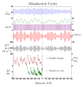
Milankovitch cycles describe the collective effects of changes in the Earth's movements on its climate over thousands of years. The term was coined and named after the Serbian geophysicist and astronomer Milutin Milanković. In the 1920s, he hypothesized that variations in eccentricity, axial tilt, and precession combined to result in cyclical variations in the intra-annual and latitudinal distribution of solar radiation at the Earth's surface, and that this orbital forcing strongly influenced the Earth's climatic patterns.

The Intertropical Convergence Zone, known by sailors as the doldrums or the calms because of its monotonous windless weather, is the area where the northeast and the southeast trade winds converge. It encircles Earth near the thermal equator though its specific position varies seasonally. When it lies near the geographic Equator, it is called the near-equatorial trough. Where the ITCZ is drawn into and merges with a monsoonal circulation, it is sometimes referred to as a monsoon trough.

Andagoya is a village in west-central Colombia. Andagoya is named for Pascual de Andagoya (1495–1548), a Spanish conquistador.
Earth orbits the Sun at an average distance of 149.60 million km in a counterclockwise direction as viewed from above the Northern Hemisphere. One complete orbit takes 365.256 days, during which time Earth has traveled 940 million km. Ignoring the influence of other Solar System bodies, Earth's orbit, also known as Earth's revolution, is an ellipse with the Earth-Sun barycenter as one focus with a current eccentricity of 0.0167. Since this value is close to zero, the center of the orbit is relatively close to the center of the Sun.
Many astronomical phenomena viewed from the planet Mars are the same as or similar to those seen from Earth; but some are quite different. For example, because the atmosphere of Mars does not contain an ozone layer, it is also possible to make UV observations from the surface of Mars.
Rainfall and the tropical climate dominate the tropical rain belt, which oscillates from the northern to the southern tropics over the course of the year, roughly following the solar equator. The tropical rain belt is an area of active rain that is positioned mostly around the tropics.
The Universal Transverse Mercator (UTM) is a map projection system for assigning coordinates to locations on the surface of the Earth. Like the traditional method of latitude and longitude, it is a horizontal position representation, which means it ignores altitude and treats the earth surface as a perfect ellipsoid. However, it differs from global latitude/longitude in that it divides earth into 60 zones and projects each to the plane as a basis for its coordinates. Specifying a location means specifying the zone and the x, y coordinate in that plane. The projection from spheroid to a UTM zone is some parameterization of the transverse Mercator projection. The parameters vary by nation or region or mapping system.

Daytime as observed on Earth is the period of the day during which a given location experiences natural illumination from direct sunlight. Daytime occurs when the Sun appears above the local horizon, that is, anywhere on the globe's hemisphere facing the Sun. In direct sunlight the movement of the sun can be recorded and observed using a sundial that casts a shadow that slowly moves during the day. Other planets and natural satellites that rotate relative to a luminous primary body, such as a local star, also experience daytime, but this article primarily discusses daytime on Earth.

Sun path, sometimes also called day arc, refers to the daily and seasonal arc-like path that the Sun appears to follow across the sky as the Earth rotates and orbits the Sun. The Sun's path affects the length of daytime experienced and amount of daylight received along a certain latitude during a given season.
The equator is a circle of latitude that divides a spheroid, such as Earth, into the Northern and Southern hemispheres. On Earth, the Equator is an imaginary line located at 0 degrees latitude, about 40,075 km (24,901 mi) in circumference, halfway between the North and South poles. The term can also be used for any other celestial body that is roughly spherical.
A season is a division of the year based on changes in weather, ecology, and the number of daylight hours in a given region. On Earth, seasons are the result of the axial parallelism of Earth's tilted orbit around the Sun. In temperate and polar regions, the seasons are marked by changes in the intensity of sunlight that reaches the Earth's surface, variations of which may cause animals to undergo hibernation or to migrate, and plants to be dormant. Various cultures define the number and nature of seasons based on regional variations, and as such there are a number of both modern and historical cultures whose number of seasons varies.
North African climate cycles have a unique history that can be traced back millions of years. The cyclic climate pattern of the Sahara is characterized by significant shifts in the strength of the North African Monsoon. When the North African Monsoon is at its strongest, annual precipitation and consequently vegetation in the Sahara region increase, resulting in conditions commonly referred to as the "green Sahara". For a relatively weak North African Monsoon, the opposite is true, with decreased annual precipitation and less vegetation resulting in a phase of the Sahara climate cycle known as the "desert Sahara".
