
New Melones Dam is an earth and rock filled embankment dam on the Stanislaus River, about 5 miles (8.0 km) west of Jamestown, California, United States, on the border of Calaveras County and Tuolumne County. The water impounded by the 625-foot-tall (191 m) dam forms New Melones Lake, California's fourth-largest reservoir, in the foothills of the Sierra Nevada east of the San Joaquin Valley. The dam serves mainly for irrigation water supply, and also provides hydropower generation, flood control, and recreation benefits.

Trinity Dam is an earthfill dam on the Trinity River located about 7 miles (11 km) northeast of Weaverville, California in the United States. The dam was completed in the early 1960s as part of the federal Central Valley Project to provide irrigation water to the arid San Joaquin Valley.

Millerton Lake is an artificial lake near the town of Friant, about 15 mi (24 km) north of downtown Fresno, California, United States. The reservoir was created by the construction of 319 ft high Friant Dam on the San Joaquin River which, with the lake, serves as much of the county line between Fresno County to the south and Madera County to the north.

Emigrant Lake is a reservoir located 5 miles (8 km) southeast of Ashland, Oregon, at the southern end of the Rogue Valley. It has an elevation of 2,241 feet (683 m) above sea level. The lake has an average surface area of 806 acres (3.26 km2), and an average volume of 40,530 acre-feet (49,990,000 m3). The lake is impounded by Emigrant Lake Dam, which stands 205 feet (62 m) above the surrounding farmland, and is located on Emigrant Creek at the west side of the lake. The spillway is at the northern tip of the lake. Emigrant Creek is a tributary of Bear Creek.
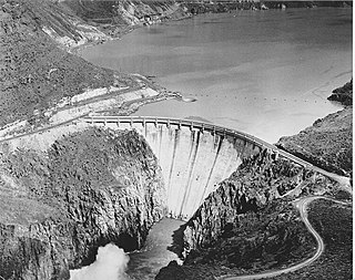
Owyhee Dam is a concrete arch-gravity dam on the Owyhee River in Eastern Oregon near Adrian, Oregon, United States. Completed in 1932 during the Great Depression, the dam generates electricity and provides irrigation water for several irrigation districts in Oregon and neighboring Idaho. At the time of completion, it was the tallest dam of its type in the world. The dam is part of the Owyhee Dam Historic District, which is listed on the National Register of Historic Places.
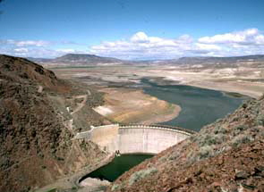
Warm Springs Reservoir is a reservoir on the boundary between Harney and Malheur counties in the U.S. state of Oregon. It is located 13 miles (21 km) southwest of Juntura at an elevation of 3,406 feet (1,038 m). The lake's primary inflow and outflow are both the Malheur River.

Unity Lake State Recreation Site is a state park in the U.S. state of Oregon, administered by the Oregon Parks and Recreation Department.

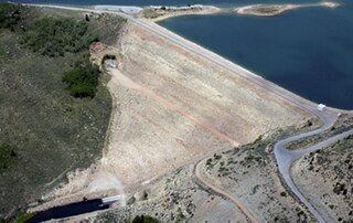
Bully Creek Reservoir is a reservoir in Malheur County of the U.S. state of Oregon. It is an impoundment of Bully Creek, a tributary of the Malheur River.

McKay Reservoir is a reservoir in Umatilla County of the U.S. state of Oregon. It is an impoundment of McKay Creek, a tributary of the Umatilla River. The reservoir is located 6 miles (9.7 km) south of Pendleton on U.S. Route 395. The reservoir has a capacity of 65,534 acre-feet (80,835,000 m3) of water. The reservoir and land that immediately surrounds it are designated as the McKay Creek National Wildlife Refuge. The reservoir and creek that it impounds are named for Dr. William C. McKay. McKay was an early settler in the Pendleton, Oregon area. He settled near the mouth of McKay Creek about 1851. The place was originally called Houtama. He died in Pendleton in 1893.

The Rio Grande Project is a United States Bureau of Reclamation irrigation, hydroelectricity, flood control, and interbasin water transfer project serving the upper Rio Grande basin in the southwestern United States. The project irrigates 193,000 acres (780 km2) along the river in the states of New Mexico and Texas. Approximately 60 percent of this land is in New Mexico. Some water is also allotted to Mexico to irrigate some 25,000 acres (100 km2) on the south side of the river. The project was authorized in 1905, but its final features were not implemented until the early 1950s.
O'Neill Dam is an earthfill dam on San Luis Creek, 12 miles (19 km) west of Los Banos, California, United States, on the eastern slopes of the Pacific Coast Ranges of Merced County. Forming the O'Neill Forebay, a forebay to the San Luis Reservoir, it is roughly 2.5 miles (4.0 km) downstream from the San Luis Dam.

Whiskeytown Dam is an earthfill dam on Clear Creek, a tributary of the Sacramento River of northern California in the United States.

The Klamath Diversion was a federal water project proposed by the U.S. Bureau of Reclamation in the 1950s. It would have diverted the Klamath River in Northern California to the more arid central and southern parts of that state. It would relieve irrigation water demand and groundwater overdraft in the Central Valley and boost the water supply for Southern California. Through the latter it would allow for other Southwestern states—Arizona, Nevada, New Mexico and Utah—as well as Mexico to receive an increased share of the waters of the Colorado River.
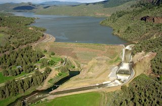
Mason Dam is a dam near Baker City, Oregon, in Baker County, of the north-eastern part of the state.
Ochoco Dam is a dam in Central Oregon, 6 miles (9.7 km) east of Prineville in Crook County, Oregon, in the United States.

Agency Valley Dam is a dam in Oregon, United States, built on the North Fork Malheur River in the eastern part of the state, immediately north of the small town of Beulah in Malheur County. The dam impounds the river to create Beulah Reservoir.

Webster Reservoir is a reservoir in Rooks County, Kansas, United States. Built and managed by the U.S. Bureau of Reclamation, it is used for flood control, irrigation, and recreation. Webster State Park is located on its shore.
Soldier Creek Dam is an earthen dam on the Strawberry River, located within the Uinta National Forest in southern Wasatch County, Utah, United States.

Platoro Dam is a dam in Conejos County, Colorado.

The Middle Rio Grande Project manages water in the Albuquerque Basin of New Mexico, United States. It includes major upgrades and extensions to the irrigation facilities built by the Middle Rio Grande Conservancy District and modifications to the channel of the Rio Grande to control sedimentation and flooding. The bulk of the work was done by the United States Bureau of Reclamation and the United States Army Corps of Engineers in the 1950s, but construction continued into the 1970s and maintenance is ongoing. The project is complementary to the San Juan–Chama Project, which transfers water from the San Juan River in the Colorado River Basin to the Rio Grande. Although distribution of water from the two projects is handled through separate allotments and contracts, there is some sharing of facilities including the river itself. The ecological impact on the river and the riparian zone was the subject of extended litigation after a group of environmentalists filed Rio Grande Silvery Minnow v. Bureau of Reclamation in 1999.


