
Warangal is a city in the Indian state of Telangana. It is the second largest city in Telangana with a population of 830,281 per 2011 Census of India, and spreading over an 406 km2 (157 sq mi). Warangal served as the capital of the Kakatiya dynasty which was established in 1163. The monuments left by the Kakatiyas include fortresses, lakes, temples and stone gateways which, in the present, helped the city to become a popular tourist attraction. The Kakatiya Kala Thoranam was included in the emblem of Telangana by the state government.
Dharmasagar is a Town and a mandal in Hanamkonda district in Telangana, India. Dharmasagar is well connected with towns like Kazipet, and Hanamakonda by road. It is 14.4 km far from its District Main Town Warangal and 122 km far from its State Capital Hyderabad.
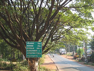
Thottada is situated on Kannur-Thalassery highway 8 km away from Kannur Railway station in Kannur District between Kannur city and Thalassery town in Kerala state, South India.
Jangaon is a town and the district headquarters of Jangaon district in the Indian state of Telangana. It is also the mandal and divisional headquarters of Jangaon Mandal and Jangaon revenue division respectively. It is about 85 kilometres (53 mi) from the state capital Hyderabad. It lies on the National Highway 163
Zaffergadh is a village and a mandal in Jangaon district of Telangana state in India. Zaffergadh got its name from a Muslim ruler Zaffarudhaula who made this place capital of his dynasty. Zaffergadh Mandal (Headquarters) is 16 km from Ghanpur (Station) and well connected with roads. Zaffergadh is about 130 km from Hyderabad. From Hyderabad you can take National Highway - 202 connecting Hyderabad with Warangal City, get off this highway at Ghanapur (Station) and continue taking road to Zaffergadh.

Narsampet is a town in Warangal district of the Indian state of Telangana. Narsampet is a Mandal in Warangal Rural District of Telangana State, India. Headquarters of Narsampet Revenue Division is in Narsampet Town. As part of Telangana Districts re-organisation, Narsampet Mandal re-organised from Warangal District to Warangal Rural district. The town is 36 km east of District Headquarter Warangal.

Kesamudram is a mandal in Mahabubabad District of the Indian state of Telangana.
Kandavara is a self-contained discrete settlement/village but is Ward 14 of the Town of Chikballapur, in the state of Karnataka, India. It is in the newly created District of Chikballapur, in the taluk (township) of Chikballapur.
Annaram is a village in Thungathurthy mandal, Suryapet district, Telangana, India. Most of the families in Annaram are very well educated and has more than one employee in the family. The village has supplied Engineers, Professors, Govt.officers, Teachers and specialists over the generations and are serving in India and abroad. Nearly 95% of population is literate. This village has three govt. schools including one high school which was started in late 1970s. Though politically very active, there aren't many notable leaders from the village. Main crops for the farmers of this village are paddy, moong, ground nut, chilli and cotton.
Punnelu is a village in Wardhannapet mandal, Warangal district, Telangana state in India.
Kothaguda is a big agency Mandal in Mulugu Constituency of Mahabubabad district of Telangana in India.
Thorrur is a revenue division, mandal and a municipality in Mahabubabad district of Telangana, India. It is located on Jayaprakash Narayana road between Warangal and Khammam. It is at about 50 km from Warangal, 62 km from Suryapet and 70 km from Khammam. It is a rapidly growing town due to its location.
Patharlapahad is a village in Athmakur (S) mandal, Suryapet district, state of Telangana, India. It is located along Suryapet and Warangal highway
Madipally is a nearly 400-year-old village in the Mahabubabad district of the Indian state of telangana. It is 6 km from Thorrur, which is about 60 km from Warangal. It is 125 km from Hyderabad.

Pedda Korpole is a village located in Nekkonda of Warangal district in Telangana state, India. It is located very near to the Kazipet Vijayawada railway line. It comes under Narsampet, Mahabubabad and Mahabubabad Revenue Division. Its PIN CODE is 506112.
Laknepalli is a village panchayat in Narsampet mandal in Warangal district in the state of Telangana in India.

Perla is an administrative capital of Enmakaje Panchayat, which is in Kasaragod district, Kerala, India.
Rajapalle is a village in Warangal district of Telangana State, India. It is located 2 kilometres (1.2 mi) from Narsampet, which is mandal of Warangal Rural. The village is administrated by a sarpanch, an elected representative of the village.
Sandragudem is a small village/hamlet in the state of Telangana, India. It has a population of 200 living in approximately 60 households, the village is 4 km (2.5 mi) from Govindharaopet mandal and 70 km (43 mi) from Warangal. The village is a part of Karlapally gram panchayath, Govindharaopet mandal. Initially, it was under Warangal district but after the creation of Telangana by bifurcation of Andhra Pradesh, it is now under Jayashanker district.
Gudibanda thanda is a village in Thorrur mandal, and a town in Mahabubabad district of Telangana, India. It is located on Jayaprakash Narayana road between Warangal and Khammam. It is at about 50 km from Warangal and 70 km from Khammam. It is a rapidly growing town due to its location. The distance between Hyderabad to Gudibanda thanda is 143 km

