Narsampet

Last updated

Narsampet
Municipality
Pakhal Lake Telangana.jpg
Pakhal Lake in Khanapur Mandal
India Telangana location map.svg
Red pog.svg
Narsampet
Location in Telangana, India
India location map.svg
Red pog.svg
Narsampet
Narsampet (India)
Coordinates: 17°55′35″N79°53′49″E / 17.926394°N 79.896941°E / 17.926394; 79.896941
CountryFlag of India.svg  India
State Telangana
District Warangal district
Talukas Narsampet
Area
[1]
  Total
11.52 km2 (4.45 sq mi)
  Rank1
Elevation
221 m (725 ft)
Population
 (2011) [2]
  Total
60,000
  Density5,200/km2 (13,000/sq mi)
Languages
  Official Telugu
Time zone UTC+5:30 (IST)
PIN
506132
Vehicle registration TG 24
Website telangana.gov.in

Narsampet is a largest Town in Warangal district of the Indian state of Telangana. [3] Headquarters of Narsampet Revenue Division (it is one of the 5 Revenue divisions in Erstwhile Warangal district). As part of Telangana Districts re-organisation, Narsampet re-organised from Warangal District to Warangal Rural district. The town is 36 km east of District Headquarter Warangal.

Contents

There are many mills which replicates rich agricultural growth in the region and colleges in the Town Such as BITS, JITS, Siddarth Degree College etc.(Recently Telangana Government opened Government Medical College in Narsampet). The Town has rice mills, oil mills, Agricultural Market Committee, and all departmental offices. The Narsampet Town is a small commercial centre, for a region covering about 240 villages including some of villages from Mahabubabad District. The villages depend on Narsampet to market their agricultural produce and to procure their consumer needs.

Geography

Narsampet is in Warangal Rural District of Telangana, at 17 degrees 55 minutes north to 79 degrees 54 minutes east. Narsampet has average altitude of 221 meters.

Administration of Narsampet

Narsampet is a minor historical place in Telangana. Narsampet was Under Nizam Rule when it was in colonial times. Before independence, the administrative unit of Narsampet was officially known as Pakhal Taluka because of its proximity to the area's lifeline - the Pakhal Lake, major lake for drinking water in the region built by the Kakatiya rulers. During Andhra Pradesh Narsampet was first upgraded as Nagara panchayat with 20 wards from major Grampanchayath (2011), Recently Government of Telangana merged the neighbouring Dwarakapet Sarvapuram, Moqdumpuram and Maheshwaram etc..villages into Narsampet Municipality. The Town has 30 wards (increased from 24 to 30) and 300 colonies.

Politics in Narsampet

BRS, BJP, and INC are the major political parties in this area. Narsampet comes under Narsampet assembly constituency, the current elected Member of Legislative Assembly(MLA) is Donthi Madhava Reddy from INC, won against the BRS candidate Peddi Sudarshan Reddy in the assembly elections held during the months of Nov-Dec 2023 and won with a majority of 18,800. The MLA is all set to swear as minister during his stint, sources say the portfolio assigned would be Agricultural Ministry for the state Telangana. Mr. Madhava Reddy was elected as MLA during the assembly election held in 2014. This mark his second victory as MLA. Narsampet comes under Mahabubabad parliament constituency, the current sitting MP is Balram Naik from INC.

Government and politics

Civic administration

Narsampet Municipality was constituted in 2011 and has 30 election wards. The jurisdiction of the civic body is spread over an area of 11.52 km2 (4.45 sq mi). [1]

Educational Institutions

Both Government and private institutions has their presence in the city.

Demographics

Narsampet is a Census Village in the district of Warangal Rural, Telangana. The population of the town as per the 2011 census is 30,231, 2024 estimate 43,000 population.

Demographics of Narsampet Town (2011) [6]

   Hinduism (90.00%)
   Islam (8.25%)
   Christianity (1.75%)

Transportation

Narsampet TSRTC Bus Depot All bus service are below

Narsampet to Hanamkonda.

Narsampet to Yellandu via kothaguda (suspended).

Narsampet to Nizamabad.

Narsampet to Adilabad.

Narsampet to Mahabubnagar(suspended).

Narsampet to Yadagirigutta (suspended).

Narsampet to Mulugu.

Narsampet to Eturnagaram.(suspended)

Narsampet to mahabubabad

Narsampet to Bhadrachalam.

Narsampet to Hyderabad.

Narsampet to Tirupati.

Narsampet to Srisailam.

Narsampet to Vishakapatnam (suspended).

Narsampet to kakinada (suspended).

Narsampet to Ongole (suspended).

Narsampet to Shiridi (suspended).

Narsampet to parkal.

Narsampet to Thorruur.

Narsampet to uparapally.

Narsampet to pakhala rampur.

Narsampet to ottai thanda.

Narsampet to saddireddypelli.

Narsampet to musimi.

Narsampet to ponugundla.

Narsampet to jangalapally.

Narsampet to vellubally.(suspended)

Narsampet to vemulawada.

Narsampet to Kaleshwaram via Mulugu.

Narsampet to Karlai/Thati vari vempally. (suspended)

Literacy

The literacy rate of Narsampet Village is 81.17% higher than the state average of 67.02%. In Narsampet, male literacy is around 89.70% while the female literacy rate is 72.13%.

Weather and Climate of Narsampet

It is hot in summer. Narsampet summer highest day temperature is between 33 °C to 46 °C. Average temperatures of January is 25 °C, February is 25 °C, March is 29 °C, April is 33 °C, May is 38 °C

Villages in Narsampet Mandal

1.Akulthanda 2.Bhanjipeta 3.Bhojyanaikthanda 4.Itikalapalli 5.Enugalthanda 6.Ippalthanda 7.Muthyalammathanda 8.Muthojipeta 9.Rajupeta 10.Chandhraiapalli 11.Rajeshwararaopalli 12.Madhannapeta 13.Nagurlapalli 14.Parshanaikthanda 15.Kammapelli 16.Dasaripalli 17.Maheshwaram 18.Ramulunaikthanda 19.Laknepalli 20.Ramavaram 21.Gurijala 22.ChinnaGurijala 23.GurralaGandi Rajapalli 24.Gunturupalli 25.Rajapalli 26.Mukdumpuram 27.Patha Mukdumpuram.

See also

Related Research Articles

<span class="mw-page-title-main">Khammam district</span> District of Telangana in India


Khammam district is a district in the eastern region of the Indian state of Telangana. The city of Khammam is the district headquarters. The district shares boundaries with Suryapet, Mahabubabad, Bhadradri districts and with Eluru and NTR districts.

<span class="mw-page-title-main">Hanamkonda district</span> District of Telangana in India

Hanamkonda district, is a district in the Indian state of Telangana. The district headquarters are located at Hanamakonda. The district borders the districts of Jangaon, Karimnagar, Warangal, Bhupalpally and Siddipet.

<span class="mw-page-title-main">Bhongir</span> Settlement in India

Bhongir, officially known as Bhuvanagiri, is a city and a district headquarters of the Yadadri Bhuvanagiri district and part of the Hyderabad Metropolitan Region of the Indian state of Telangana.

Jangaon (Janagama) is a city and the district headquarters of Jangaon district in the Indian state of Telangana. It is also the mandal and divisional headquarters of Jangaon Mandal and Jangaon revenue division respectively. It is about 85 kilometres from the state capital Hyderabad. It lies on the National Highway 163.

<span class="mw-page-title-main">Sircilla</span> Town in Telangana, India

Siricilla is a town and the district headquarters of Rajanna Siricilla district in the Indian state of Telangana. It is located on the banks of Manair river in the Siricilla mandal of Siricilla revenue division. It is popularly known as Textile Town due to the presence of large number of power looms, textile processing and dyeing units. It is the biggest textile hub in the state of Telangana with over 40,000 power looms. Siricilla, along with Warangal is proposed to be developed as a mega textile zone by the Telangana government. The first Visalandhra Mahasabha in Telangana was held at Siricilla during the Visalandhra movement.

<span class="mw-page-title-main">Wanaparthy</span> Town in Telangana, India

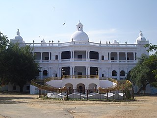
Wanaparthy is a town in the Wanaparthy district of Telangana, India. The first polytechnic college in Telangana started in Wanaparthy. It is located 149 km from the state capital, Hyderabad.

<span class="mw-page-title-main">Mahabubabad</span> City in Telangana, India

Mahabubabad is a city and the district headquarters of Mahabubabad district in the Indian state of Telangana. It is on the west bank of the Munneru, which is one of the tributaries of the River Krishna. Mahabubabad is known for the Bayyaram Mines. Kuravi virabadraswamy temple

<span class="mw-page-title-main">Mulugu district</span> District of Telangana in India

Sammakka Saralamma Mulugu district is a district located in the eastern region of the Indian state of Telangana. Its headquarters is the town of Mulugu. Mulugu district is the least populated district with 294,671 in the state. Mulugu district has the fewest mandals in the state with nine mandals. It currently borders Warangal, Mahabubabad, Jayashankar Bhupalpally and Bhadradri districts and with the state of Chhattisgarh.

<span class="mw-page-title-main">Veeramalla Prakash</span> Indian advocate and writer

Veeramalla Prakash Rao, known as Telangana Prakash, is an advocate, writer and the co-founder of Bharat Rashtra Samithi, a Regional Party in India.

Kothaguda is an agency mandal in Mulugu Constituency of Mahabubabad district of the Indian state of Telangana.

NATIONAL HIGHWAY 930p

Mulugu is a town in Mulugu district, Telangana. It is the headquarters of the district, which was formed in 2019 after Jayashankar Bhupalpally district was split. Prior to the reorganization of districts that created Jayashankar Bhupalpally district, Mulugu was a part of the Warangal district. It lies on National Highway 163.

Narsampet Assembly constituency is a constituency of Telangana Legislative Assembly, India. It is one of the constituencies in Warangal district. It is part of Mahabubabad Lok Sabha constituency.

A. Sitaram Naik is an Indian politician and academic. He was elected to the 16th Lok Sabha in 2014 General Elections. He represents Mahbubabad Lok Sabha constituency.

<span class="mw-page-title-main">Warangal district</span> District of Telangana in India

Warangal district, formerly Warangal Rural district, is a district in the Indian state of Telangana. The district shares boundaries with Mahabubabad, Jangaon, Hanamkonda, Mulugu and Bhupalpally districts.

<span class="mw-page-title-main">Mahabubabad district</span> District of Telangana in India

Mahabubabad district also known as Manukota district is a district in the Indian state of Telangana. The district was carved out from the erstwhile Warangal district following the re-organisation of districts in the state in October 2016. The district shares boundaries with Suryapet, Khammam, Bhadradri, Warangal, Mulugu and Jangaon districts.

<span class="mw-page-title-main">Bhadradri Kothagudem district</span> District in Telangana, India

Bhadradri Kothagudem is a district in the east of the Indian state of Telangana. Kothagudem is the district headquarters. It is the largest district in Telangana, with an area of 7483 km2. It borders the districts Khammam, Mahabubabad, Mulugu, Eluru and East Godavari, and shares a boundary with the bordering states Chhattisgarh and Andhra Pradesh. The district comprises 24 mandals and 2 revenue divisions, Kothagudem and Bhadrachalam.

Gudur is a village and also a mandal in Mahabubabad District of Telangana State, India. The Gudur mandal headquarters are situated in Gudur.

Donthi Madhava Reddy is an Indian politician from Telangana state. He is an MLA from Narasampet Assembly constituency in Warangal district. He represents Indian National Congress and won the 2023 Telangana Legislative Assembly election.

Gangaram is an agency mandal in Mulugu Constituency of Mahabubabad district of the Indian state of Telangana.

References

  1. 1 2 "Urban Local Body Information" (PDF). Directorate of Town and Country Planning. Government of Telangana. Archived from the original (PDF) on 15 June 2016. Retrieved 28 June 2016.
  2. Warangal District Census Handbook
  3. "Warangal (urban) district" (PDF). New Districts Formation Portal. Archived from the original (PDF) on 11 October 2016. Retrieved 11 October 2016.
  4. https://www.bitswgl.ac.in/ [ bare URL ]
  5. https://gdcts.cgg.gov.in/narsampet.edu [ bare URL ]
  6. "Table C-16 Population by Mother Tongue: Andhra Pradesh". Census of India . Registrar General and Census Commissioner of India.