
The Deschutes River in central Oregon is a major tributary of the Columbia River. The river provides much of the drainage on the eastern side of the Cascade Range in Oregon, gathering many of the tributaries that descend from the drier, eastern flank of the mountains. The Deschutes provided an important route to and from the Columbia for Native Americans for thousands of years, and then in the 19th century for pioneers on the Oregon Trail. The river flows mostly through rugged and arid country, and its valley provides a cultural heart for central Oregon. Today the river supplies water for irrigation and is popular in the summer for whitewater rafting and fishing.

The Kings River is a 132.9-mile (213.9 km) river draining the Sierra Nevada mountain range in central California in the United States. Its headwaters originate along the Sierra Crest in and around Kings Canyon National Park and form the eponymous Kings Canyon, one of the deepest river gorges in North America. The river is impounded in Pine Flat Lake before flowing into the San Joaquin Valley southeast of Fresno. With its upper and middle course in Fresno County, the Kings River diverges into multiple branches in Kings County, with some water flowing south to the old Tulare Lake bed and the rest flowing north to the San Joaquin River. However, most of the water is consumed for irrigation well upstream of either point.

The Malheur River is a 190-mile-long (306 km) tributary of the Snake River in eastern Oregon in the United States. It drains a high desert area, between the Harney Basin and the Blue Mountains and the Snake.

The Sevier River is a 385-mile (620 km)-long river in the Great Basin of southwestern Utah in the United States. Originating west of Bryce Canyon National Park, the river flows north through a chain of high farming valleys and steep canyons along the west side of the Sevier Plateau, before turning southwest and terminating in the endorheic basin of Sevier Lake in the Sevier Desert. It is used extensively for irrigation along its course, with the consequence that Sevier Lake is usually dry.

The Walker River is a river in west-central Nevada in the United States, approximately 62 miles (100 km) long. Fed principally by snowmelt from the Sierra Nevada mountains of California, it drains an arid portion of the Great Basin southeast of Reno and flows into the endorheic basin of Walker Lake. The river is an important source of water for irrigation in its course through Nevada; water diversions have reduced its flow such that the level of Walker Lake has fallen 160 feet (49 m) between 1882 and 2010. The river was named for explorer Joseph Reddeford Walker.

The Kern River, originally Rio de San Felipe, later La Porciuncula, is a river in the U.S. state of California, approximately 165 miles (270 km) long. It drains an area of the southern Sierra Nevada mountains northeast of Bakersfield. Fed by snowmelt near Mount Whitney, the river passes through scenic canyons in the mountains and is a popular destination for whitewater rafting and kayaking. It is the southernmost major river system in the Sierra Nevada, and is the only major river in the Sierra that drains in a southerly direction.
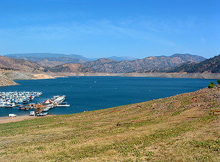
Pine Flat Lake is an artificial lake or reservoir in the Sierra Nevada foothills of eastern Fresno County, California on the western north-south border to the Sierra- and Sequoia National Forests, about 30 mi (48 km) east of Fresno. The lake is managed by the U.S. Army Corps of Engineers (USACE) and is open to boaters, campers & hikers.
Silver Creek Reservoir also known as Silverton Reservoir is a sixty-five-acre impoundment on Silver Creek located in the Cascade foothills 2.5 miles (4.0 km) southeast of the city of Silverton, Oregon, United States on Oregon Route 214. The reservoir serves the purpose of flood control on the creek.

The Crooked River is a tributary, 125 miles (201 km) long, of the Deschutes River in the U.S. state of Oregon. The river begins at the confluence of the South Fork Crooked River and Beaver Creek. Of the two tributaries, the South Fork Crooked River is the larger and is sometimes considered part of the Crooked River proper. A variant name of the South Fork Crooked River is simply "Crooked River". The Deschutes River flows north into the Columbia River.

Owyhee Reservoir or Owyhee Lake is a reservoir on the Owyhee River in Malheur County, Oregon, United States. Located in far Eastern Oregon near the Idaho border, the reservoir is Oregon's longest at 52 miles (84 km). The 13,900-acre (56 km2) lake is home to several species of fish, including crappie, rainbow trout, largemouth bass, smallmouth bass, yellow perch, and brown bullhead. An artificial lake, it was created in 1932 with the completion of the Owyhee Dam. The lake supplies water for irrigation for 1,800 farms covering 118,000 acres of land in Eastern Oregon and Southwestern Idaho. Seasonal Lake Owyhee State Park is located on the northeast shore and includes a boat ramp.

Chickahominy Reservoir is located near U.S. Highway 20 100 miles (160.9 km) east of Bend, Oregon, and 32 miles (51.5 km) west of Burns, Oregon, in the United States. It was built as an irrigation reservoir, but is now managed by Oregon Department of Fish and Wildlife as a recreational fishery. The reservoir is very long and is narrow at points, almost pinched at the center.

The Chewaucan River is part of the Great Basin drainage. It flows 53 miles (85 km) through the Fremont–Winema National Forests, Bureau of Land Management land, and private property in southern Oregon. Its watershed consists of 651 square miles (1,690 km2) of conifer forest, marsh, and rural pasture land. The river provides habitat for many species of wildlife including native Great Basin redband trout a subspecies of rainbow trout.

McKay Reservoir is a reservoir in Umatilla County of the U.S. state of Oregon. It is an impoundment of McKay Creek, a tributary of the Umatilla River. The reservoir is located 6 miles (9.7 km) south of Pendleton on U.S. Route 395. The reservoir has a capacity of 65,534 acre feet (80,835,000 m3) of water. The reservoir and land that immediately surrounds it are designated as the McKay Creek National Wildlife Refuge. The reservoir and creek that it impounds are named for Dr. William C. McKay. McKay was an early settler in the Pendleton, Oregon area. He settled near the mouth of McKay Creek about 1851. The place was originally called Houtama. He died in Pendleton in 1893.

The American River is a ~30-mile-long river in California that runs from the Sierra Nevada mountain range to its confluence with the Sacramento River in the Sacramento Valley. Via the Sacramento River, it is part of the San Francisco Bay watershed. This river is fed by the melting snowpack of the Sierra Nevada and its many headwaters and tributaries, including the North Fork American River, the Middle Fork American River, and the South Fork American River.

The Summer Lake Wildlife Area is a 29.6-square-mile (77 km2) wildlife refuge located on the northwestern edge of the Great Basin drainage in south-central Oregon. It is administered by the Oregon Department of Fish and Wildlife. The refuge is an important stop for waterfowl traveling along the Pacific Flyway during their spring and fall migrations. The Summer Lake Wildlife Area also provides habitat for shorebirds and other bird species as well as wide variety of mammals and several fish species. The Ana River supplies the water for the refuge wetlands.

Silver Creek is an 87-mile (140 km) stream of Oregon which drains a portion of the endorheic Harney Basin to Harney Lake. Arising in the Blue Mountains, it flows generally southeast, although much of the stream is intermittent. The Silver Creek Volcanic Field is associated with the creek's watershed.

The North Fork Malheur River is a 59-mile (95 km) tributary of the Malheur River in eastern Oregon in the United States. Rising in Big Cow Burn in the Blue Mountains, it flows generally south to join the larger river at Juntura. The upper 25.5 miles (41.0 km) of the river have been designated Wild and Scenic. This part of the river basin offers camping, hiking, and fishing opportunities in a remote forest setting. The lower river passes through Beulah Reservoir, which stores water for irrigation and has facilities for boaters.

Blue River Reservoir is an artificial impoundment, about 6 miles (10 km) long, of the Blue River in Lane County in the U.S. state of Oregon. The reservoir is about 1 mile (1.6 km) north of Oregon Route 126 in the Willamette National Forest about 45 miles (72 km) east of Eugene.

Antelope Reservoir is a large body of water impounded for irrigation in a semi-arid region of southeastern Oregon in the United States. Located near the small city of Jordan Valley in Malheur County, it is about 10 miles (16 km) west of Oregon's border with Idaho. Although the lake is formed by a dam across Jack Creek, most of the water enters the reservoir via the Antelope Feeder Canal. It diverts water to the reservoir from nearby Jordan Creek at a point near the Idaho border. Jack Creek, which carries minor outflows from the reservoir, empties into Jordan Creek further downstream.

Fall Creek is a 34-mile (55 km) tributary of the Middle Fork Willamette River in Lane County in the U.S. state of Oregon. Beginning in the Cascade Range, the creek flows generally west through the Willamette National Forest to enter the Middle Fork upstream of Jasper, southeast of Springfield and Eugene.

