
Asia are an English rock supergroup formed in London in 1981. The most commercially successful lineup was its original, which consisted of four members of different progressive rock bands who had enjoyed great success in the 1970s: lead vocalist and bassist John Wetton, guitarist Steve Howe (Yes), keyboardist Geoff Downes and drummer Carl Palmer. Their self-titled debut album released in 1982, remains their best-selling album and went to number one in several countries. Billboard listed it as the top album in the U.S. in 1982. The lead single from the album, "Heat of the Moment", remains their top charting and best-known song, reaching the top 40 in over a dozen markets. It peaked at #4 in the U.S. on the Billboard Hot 100 and hit #1 on the Billboard Mainstream Rock chart.

The River Manifold is a river in Staffordshire, England. It is a tributary of the River Dove.
Staffordshire Moorlands is a local government district in Staffordshire, England. Its council is based in Leek, the district's largest town. The district also contains the towns of Biddulph and Cheadle, along with a large rural area containing many villages. North-eastern parts of the district lie within the Peak District National Park.

Longnor is a village in the Staffordshire Peak District, England. The settlement dates from early times, the first recorded church building being in the Middle Ages. The village was named Longenalre in the Domesday Book. Located on a major crossroads, Longnor was a significant market town in the 18th century. It lies on the north bank of the River Manifold, on a limestone ridge between the Manifold and the River Dove.

Ilam is a village in the Staffordshire Peak District of England, lying on the River Manifold. The population of the civil parish as taken at the 2011 census was 402.

The Leek and Manifold Valley Light Railway (L&MVLR) was a narrow gauge railway in Staffordshire, England that operated between 1904 and 1934. The line mainly carried milk from dairies in the region, acting as a feeder to the 4 ft 8+1⁄2 instandard gauge system. It also provided passenger services to the small villages and beauty spots along its route. The line was built to a 2 ft 6 in narrow gauge and to the light rail standards provided by the Light Railways Act 1896 to reduce construction costs.
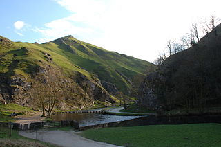
Dovedale is a valley in the Peak District of England. The land is owned by the National Trust and attracts a million visitors annually. The valley was cut by the River Dove and runs for just over 3 miles (5 km) between Milldale in the north and a wooded ravine, near Thorpe Cloud and Bunster Hill, in the south. In the wooded ravine, a set of stepping stones cross the river and there are two caves known as the Dove Holes.

Thor's Cave is a natural cavern located at SK09865496 in the Manifold Valley of the White Peak in Staffordshire, England. It is classified as a karst cave. Located in a steep limestone crag, the cave entrance, a symmetrical arch 7.5 metres wide and 10 metres high, is prominently visible from the valley bottom, around 80 metres (260 feet) below. Reached by an easy stepped path from the Manifold Way, the cave is a popular tourist spot, with views over the Manifold Valley. The second entrance is known as the "West Window", below which is a second cave, Thor's Fissure Cavern.

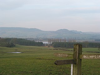
Ecton is a hamlet in the Staffordshire Moorlands in Staffordshire, England. It is near the Peak District. It is on the Manifold Way, an 8-mile (13 km) walk and cycle path that follows the line of the former Leek and Manifold Valley Light Railway. Population details as at the 2011 census can be found under Ilam.
The Manifold Way is a footpath and cycle way in Staffordshire, England. Some 8 miles (13 km) in length, it runs from Hulme End (53.1307°N 1.8480°W) in the north to Waterhouses (53.0480°N 1.8654°W) in the south, mostly through the Manifold Valley and the valley of its only tributary, the River Hamps, following the route of the former Leek and Manifold Valley Light Railway, a 2 ft 6 in gauge line which closed in 1934 after a short life.

Grindon is a small village in the Staffordshire Moorlands district of Staffordshire, England. Close to the Peak District.

Sparrowlee a railway station on the Leek and Manifold Valley Light Railway, a 2 ft 6 in narrow gauge line which ran for 8 miles between Hulme End and Waterhouses, in Staffordshire, and was initially operated by the North Staffordshire Railway before being taken over by the LMS. It served the village of Waterfall in Staffordshire, England.
Wetton is a village in the Staffordshire Moorlands in Staffordshire, England. It is in the Peak District and at the top of the east side of the Manifold Valley. The population recorded in the 2001 Census was 157. At the time of the 2011 Census the population was recorded under Ilam. This article describes the location, some of the main features of the village, and a number of places of historical or general interest in or near the village. These include Long Low, Wetton, a prehistoric burial site unique to England.

Hulme End railway station is a disused railway station at Hulme End in Staffordshire, England.
Ecton railway station was a station on the Leek and Manifold Light Railway. It served the hamlet of Ecton and village of Warslow in Staffordshire, England. It opened to the public on 29 June 1904 and was in operation for almost thirty years prior to its closure on 12 March 1934. Ecton Creamery opened in 1920 and the line was used for transporting Stilton cheese. An Ordnance Survey map published in 1922 shows a branch line running to the cheese factory. Milk was transported by road from 1932, leading to a decline in revenue for the railway. In 1937, owner London, Midland & Scottish Railway gifted the track bed to Staffordshire County Council for a public right of way, pioneering such transfers in Britain. Today, the site is part of the Manifold Way that runs between Hulme End and Waterhouses.

Butterton railway station was a station on the Leek and Manifold Light Railway. It served the village of Butterton in Staffordshire, England. The site is now part of the Manifold Way including the Swainsley Tunnel.

Wetton Mill was a railway station on the Leek and Manifold Light Railway serving the nearby Wetton Mill in Wetton, Staffordshire. It was in operation from 1904 to 1934. A painting of the station dating from 1905 by the railway artist C. Hamilton Ellis is now held by the National Railway Museum at York. The site now forms part of the Manifold Way.
Redhurst Crossing was a railway station on the Leek and Manifold Light Railway, located between Wetton Mill railway station, Staffordshire and Thor's Cave railway station. Not much is documented about the halt, and the line which ran through it is now the Manifold Way.

Grindon railway station was a station on the Leek and Manifold Light Railway. It served the village of Grindon in Staffordshire. The site is now part of the Manifold Way.

Beeston Tor was a railway station which served the Beeston Tor and village of Grindon in Staffordshire, England. It opened in 1904 and closed in 1934 The site is now part of the Manifold Way.
