Yangtze or Yangzi is the longest river in Eurasia and the third-longest in the world. It rises at Jari Hill in the Tanggula Mountains of the Tibetan Plateau and flows 6,300 km (3,915 mi) in a generally easterly direction to the East China Sea. It is the fifth-largest primary river by discharge volume in the world. Its drainage basin comprises one-fifth of the land area of China, and is home to nearly one-third of the country's population.
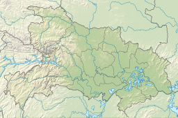
Sichuan is a province in Southwestern China, occupying the Sichuan Basin and Tibetan Plateau—between the Jinsha River to the west, the Daba Mountains to the north, and the Yunnan–Guizhou Plateau to the south. Its capital city is Chengdu, and its population stands at 83 million. Sichuan neighbors Qinghai and Gansu to the north, Shaanxi and Chongqing to the east, Guizhou and Yunnan to the south, and Tibet to the west.

The Three Gorges Dam is a hydroelectric gravity dam that spans the Yangtze River near Sandouping in Yiling District, Yichang, Hubei province, central China, downstream of the Three Gorges. The world's largest power station by installed capacity (22,500 MW), the Three Gorges Dam generates 95±20 TWh of electricity per year on average, depending on the amount of precipitation in the river basin. After the extensive monsoon rainfalls of 2020, the dam's produced nearly 112 TWh in a year, breaking the previous world record of ~103 TWh set by Itaipu Dam in 2016.

Hubei is a province in Central China. It has the seventh-largest economy among Chinese provinces, the second-largest within Central China, and the third-largest among inland provinces. Its provincial capital at Wuhan serves as a major political, cultural, and economic hub for the region.

The Three Gorges are three adjacent and sequential gorges along the middle reaches of the Yangtze River path, in the hinterland of the People's Republic of China. With a subtropical monsoon climate, they are known for their scenery.

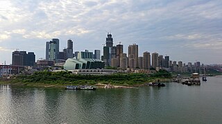
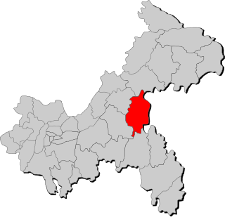
Chongqing is a direct-administered municipality in Southwestern China. Chongqing is one of the four direct-administered municipalities under the Central People's Government, along with Beijing, Shanghai, and Tianjin. It is the only directly administrated municipality located deep inland. The municipality covers a large geographical area roughly the size of Austria, which includes several disjunct urban areas in addition to Chongqing proper. Due to its classification, the municipality of Chongqing is the largest city proper in the world by population, though Chongqing is not the most populous urban area.

Dongting Lake is a large, shallow lake in northeastern Hunan Province, China. It is a flood basin of the Yangtze River, so its volume depends on the season. The provinces of Hubei and Hunan are named after their location relative to the lake: Hubei means "North of the Lake" and Hunan, "South of the Lake".

Jingzhou is a prefecture-level city in southern Hubei province, China, located on the banks of the Yangtze River. Its total residential population was 5,231,180 based on the 2020 census, 1,068,291 of whom resided in the built-up area comprising two urban districts.

Yichang, alternatively romanized as Ichang, is a prefecture-level city located in western Hubei province, China. Yichang had a population of 3.92 million people at the 2022 census, making it the third most populous city in Hubei. The city is famous for the Three Gorges, the Three Gorges Dam and the Gezhouba Dam, all three of which are located in Yiling District, one of the city's districts.

Xiangxi Tujia and Miao Autonomous Prefecture is an autonomous prefecture of the People's Republic of China. It is located in northwestern Hunan province. It consists of one city, Jishou, and seven counties: Baojing, Fenghuang, Guzhang, Huayuan, Longshan, Luxi, and Yongshun. Jishou is the capital. Of the 2,480,000 residents, 66.6% are ethnic minorities from 25 different ethnic groups, including 860,000 Tujia and 790,000 Miao.
Enshi Tujia and Miao Autonomous Prefecture is located in the mountainous southwestern corner of Hubei province, People's Republic of China. It forms Hubei's southwestern "panhandle", bordering on Hunan in the south and Chongqing Municipality in the west and northwest. The Yangtze River crosses the prefecture's northeastern corner in Badong County.
The Qing River is a right (southern) tributary of the Yangtze River in Hubei province of south-central China.

The South–North Water Transfer Project, also translated as the South-to-North Water Diversion Project, is a multi-decade infrastructure mega-project in China that aims to channel 44.8 cubic kilometers of fresh water each year from the Yangtze River in southern China to the more arid and industrialized north through three canal systems:

Xiling Gorge is a gorge on the Yangtze River in Hubei province, China. It is the easternmost and largest of the Three Gorges.
Liangjiang New Area is a state-level new area established in 2010 located within the City of Chongqing, China. The area covers 1,205 square kilometres combining part of Jiangbei District, Yubei District, and Beibei District.
Shizhu Tujia Autonomous County, or Shizhu County for short, is located in southeastern Chongqing, China. It is south of the Yangtze River, and borders the Chongqing divisions of Pengshui County to the south, Fengdu County to the southwest, Zhong County to the northwest and Wanzhou District to the north; to the east, it borders the Hubei county-level city of Lichuan. It's in the center zone of Three Gorges Reservoir Region, and the only autonomous county which designated for only one of ethnic minorities in this region.
The 2011 China floods were a series of floods from June to September 2011 that occurred in central and southern parts of the People's Republic of China. They were caused by heavy rain that inundated portions of 12 provinces, leaving other provinces still suffering a prolonged drought, and with direct economic losses of nearly US$6.5 billion.

The Shanghai–Chengdu Expressway, designated as G42 and commonly referred to as the Hurong Expressway is an east–west bound expressway that connects the eastern metropolis of Shanghai to Chengdu, the capital city of Sichuan. The expressway passes through six provinces and serves major cities such as Suzhou, Wuxi, Changzhou, Nanjing, Hefei, Wuhan, and Yichang. The eastern terminus of G42 is at the Wuning Road Interchange of Shanghai Middle Ring Road. At its western terminus, the expressway intersects the East 3rd Ring Road and connects East Erxianqiao Road in Chenghua District, Chengdu. The expressway spans 1,960 km (1,220 mi) in length.

The West Triangle Economic Zone is an economic zone designated by the Chinese government comprising Chengdu, Chongqing and Xi'an. Created as part of China's Western Development strategy, the West Triangle Economic Zone contributes nearly 40% of Western China's GDP. Furthermore, Chongqing is one of China's five National Central Cities, while both Chengdu and Xi'an are Regional Central Cities.
The economy of Chongqing, China, has developed rapidly since it was separated from the Sichuan and became a centrally-administered municipality in 1997. In 2019, it was the sixth-largest Chinese city economy and ranked as China's third-largest municipal economy. In China's overall layout, Chongqing is also important for connecting China's underdeveloped western region with its more advanced eastern region, as well as promoting the economy of the mid-lower reaches of Yangtze river and the central western region.