
Homebush is a suburb in the Inner West of Sydney in the state of New South Wales, Australia. It is located 12 kilometres west of the Sydney central business district, in the local government area of the Municipality of Strathfield.
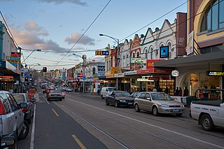
Hawthorn is an inner suburb of Melbourne, Victoria, Australia, 6 kilometres (3.7 mi) east of Melbourne's central business district, located within the City of Boroondara local government area. Hawthorn recorded a population of 22,322 at the 2021 census.

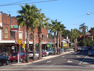
Leichhardt is a suburb in the Inner West of Sydney, in the state of New South Wales, Australia. Leichhardt is located 5 kilometres west of the Sydney central business district (CBD) and is the administrative centre for the local government area (LGA) of the Inner West Council. The suburb is bordered by Haberfield to the west, Annandale to the east, Lilyfield to the north and Petersham, Lewisham and Stanmore to the south.

Doncaster East is a suburb of Melbourne, Victoria, Australia, 20 km east of Melbourne's Central Business District, located within the City of Manningham local government area. Doncaster East recorded a population of 30,926 at the 2021 census.

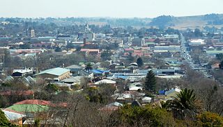
Vereeniging is a city located in the south of Gauteng province, South Africa, situated where the Klip River empties into the northern loop of the Vaal River. It is also one of the constituent parts of the Vaal Triangle region and was formerly situated in the Transvaal province. The name Vereeniging is the Dutch word meaning "association".
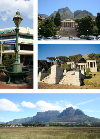
Rondebosch is one of the Southern Suburbs of Cape Town, South Africa. It is primarily a residential suburb, with shopping and business districts as well as the main campus of the University of Cape Town.
Croydon is a suburb in the Inner West of Sydney, in the state of New South Wales, Australia. It is located 9 kilometres (5.6 mi) west of the Sydney central business district. Croydon is split between the two local government areas of Municipality of Burwood and the Inner West Council.

Alberton is a town situated on the southern part of the East Rand of the Gauteng Province in South Africa and is situated very close to the major urban centre of Johannesburg.

Vanderbijlpark is an industrial city with approximately 95,000 inhabitants, situated on the Vaal River in the south of Gauteng province, South Africa. The city is named after Hendrik van der Bijl, an electrical engineer and industrialist.
Bethlehem is a city in the eastern Free State province of South Africa that is situated on the Liebenbergs river along a fertile valley just north of the Rooiberg Mountains on the N5 road. It is the fastest growing city in the Free state province, with its target of being the third largest city after Bloemfontein and Welkom.

The R82 is a provincial route in South Africa that connects Johannesburg with Kroonstad via Vereeniging and Sasolburg. It starts just south of the M1 Johannesburg Municipal Highway's interchange with the N12 Southern Bypass, going south, meeting the R59, R54, R42 & R28 routes at Vereeniging before crossing the Vaal River into the Free State & proceeding to Kroonstad. It is an alternative, but longer route to the N1 National Route between Johannesburg & Kroonstad.
Pinelands is an affluent garden city suburb located on the edge of the southern suburbs of Cape Town, South Africa, neighbouring the suburb of Thornton, and is known for its large thatched houses and green spaces. The suburb is primarily residential and is often praised for its peacefulness and abundance of trees. Pinelands is one of the few areas in Cape Town in which sale of alcohol to the public is prohibited, but some clubs have private liquor licenses. It is a popular place for senior citizens to retire to. While there are several retirement homes in the suburb, younger people are increasingly moving in.
Houghton Estate, often simply called Houghton, is an affluent suburb of Johannesburg, South Africa, north-east of the city centre.

St Marys is a suburb in western Sydney, in the state of New South Wales, Australia. It is 45 kilometres west of the Sydney central business district, in the local government area of the City of Penrith.

Campsie is a suburb in the state of New South Wales, Australia. Campsie is 11 kilometres south west of the Sydney central business district, on the southern bank of the Cooks River. Campsie is one of the administrative centres of the City of Canterbury-Bankstown.

Somerset West is a town in the Western Cape, South Africa. Organisationally and administratively it is included in the City of Cape Town metropolitan municipality as a suburb of the Helderberg region . The vehicle registration code for Somerset West is CFM and the post code is 7130 for street addresses, and 7129 for post office boxes.

Durbanville is a town in the Western Cape province of South Africa, part of the greater Cape Town metropolitan area. Durbanville is a semi-rural residential suburb on the north-eastern outskirts of the metropolis surrounded by farms producing wine and wheat.

Annandale is a suburb in the Inner West of Sydney, in the state of New South Wales, Australia. Annandale is located within 5 kilometres west of the Sydney central business district and is part of the local government area of the Inner West Council. Annandale's northern end lies on Rozelle Bay, which is on Sydney Harbour. Glebe lies to its east, Lilyfield and Leichhardt to its west and Stanmore and Camperdown to its south.

Abbeyview is a housing estate in the town of Dunfermline in Fife, Scotland. It is situated in the east of the town, approximately 2 miles from the town centre. Most of the streets in the area are named after Scottish rivers and islands.

Three Rivers Proper is a suburb of Vereeniging, Gauteng, South Africa.


