
Cicero is a town in northern Onondaga County, New York, United States. The population was 31,632 at the 2010 census. The name of the town was assigned by a clerk interested in the classics, honoring Cicero, a Roman statesman.

Hamersley is a residential suburb 14 kilometres north-northwest of the central business district of Perth, the capital of Western Australia, and six kilometres (4 mi) from the Indian Ocean. The suburb adjoins two major arterial roads—Mitchell Freeway to the west and Reid Highway to the south—and is within the City of Stirling local government area. It was built during the late 1960s and 1970s as part of the Government of Western Australia's response to rapidly increasing land prices across the metropolitan area.

Vereeniging is a city located in the south of Gauteng province, South Africa, situated where the Klip River empties into the northern loop of the Vaal River. It is also one of the constituent parts of the Vaal Triangle region and was formerly situated in the Transvaal province. The name Vereeniging is derived from the Dutch word meaning "union".
The Eastern Region was an administrative region in Nigeria, dating back originally from the division of the colony Southern Nigeria in 1954. Its first capital was Calabar. The capital was later moved to Enugu and the second capital was Umuahia. The region was officially divided in 1967 into three new states, the East-Central State, South-Eastern State. East-Central State had its capital at Enugu, which is now part of Enugu State.
High Wycombe is a suburb of Perth, Western Australia, within the City of Kalamunda. High Wycombe lies east of the Perth CBD at the base of the Darling Scarp. Formerly part of Maida Vale, the suburb was officially declared on 2 June 1978; its name, which was first used in 1958 by a subdivider, Western Agencies, and refers to the town in Buckinghamshire where one of the partners in the firm was born.

Brackenfell is a town in the Western Cape province of South Africa at the gateway to the Cape Winelands. Organisationally and administratively it is included in the City of Cape Town Metropolitan Municipality as a Northern Suburb and is about 30 kilometres (19 mi) east of Cape Town City Bowl. In Brackenfell a variety of property situated on the slopes of the Bottelary Hills can be found.
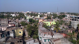
Rampurhat is a city and a municipality in Birbhum district in the Indian state of West Bengal. It is the headquarters of the Rampurhat subdivision. According to Census 2011 Rampurhat is the third most populous city in Birbhum district and 82th most populous city in West Bengal. Rampurhat is a rapidly growing township It is near the West Bengal / Jharkhand border. Rampuhat is an important city of Birbhum district as it has dynamic connectivity with the other places of West Bengal and neighboring states via state highways, national highway and rail route. Rampurhat Junction is one of the busiest railway stations in eastern India.
The Border Rivers are a group of Australian rivers and the associated region near part of the state border between New South Wales and Queensland.
Mutasa District is one of seven districts in Manicaland Province of Zimbabwe. Mutasa District is located 30 km northeast Mutare and stretches up to the Honde Valley, which is about 100 km northeast of Mutare along a tarred road that branches off the Nyanga road.

Chemperi is a town on the bank of the Chemperi River, in the Western Ghat, in the Kannur district of South India. Chemperi is often referred as the education city of Kannur with the establishment of Vimal Jyothi Engineering College, Chemperi. It is characterized by its production and export of rubber and spices, its beautiful hillocks, and its serene streams. Village and Panchayath of Chemperi is Eruvessi. Both Panchayath and Village offices of Eruvessi are located in Chemperi. Also Lourde Matha Forane Church, Chemperi is another attraction.Paithalmala and Palakkayam thatt is also a few kilometres away from here.

Midvaal Local Municipality is an administrative area within the Sedibeng District Municipality of Gauteng in South Africa. The municipality's name references its geographical location halfway between the Johannesburg and East Rand areas and the Vaal and Vereeniging areas.

The share of agriculture in Austria in the Austrian economy declined steadily after World War II, agriculture continues to represent an important element of the economy because of its social and political significance. The Chamber of Agriculture remains on an equal level with the chambers of commerce and labor, although its members produce only a fraction of the GDP that industrial and commercial workers produce.
Nellikutty is a small hamlet resting on the lap of the Western Ghat in India. The modern history of this village starts with the arrival of migrants from Ramapuram, Kottayam District of Kerala during the 1930s. The hard work of the migrants made Nellikutty a town with almost all the facilities to meet the basic needs of its population.
Murarai is a census town in Murarai I CD block in Rampurhat subdivision of Birbhum district in the Indian state of West Bengal.
Satpalsa is a village in Mayureswar II CD Block in Rampurhat subdivision of Birbhum district in the Indian state of West Bengal.
Barua Gopalpur is a census town in Murarai I CD block in Rampurhat subdivision of Birbhum district.
Ambhua is a census town in Murarai I CD block in Rampurhat subdivision of Birbhum district.
Kashimnagar is a census town in Murarai II CD block in Rampurhat subdivision of Birbhum district.
Bishnupur is a census town in Rampurhat II CD block in Rampurhat subdivision of Birbhum district.


