Related Research Articles

Osage County is the largest county by area in the U.S. state of Oklahoma. Created in 1907 when Oklahoma was admitted as a state, the county is named for and is home to the federally recognized Osage Nation. The county is coextensive with the Osage Nation Reservation, established by treaty in the 19th century when the Osage relocated there from Kansas. The county seat is in Pawhuska, one of the first three towns established in the county. The total population of the county as of 2020 was 45,818.

Noble County is a county located in the north central part of Oklahoma. As of the 2020 census, the population was 10,924. Its county seat is Perry. It was part of the Cherokee Outlet in Indian Territory until Oklahoma Territory was created in 1890, and the present county land was designated as County P. After the U. S. government opened the area to non-Indian settlement in 1893, it was renamed Noble County for John Willock Noble, then the United States Secretary of the Interior.

Kay County is a county located in the U.S. state of Oklahoma. As of the 2020 census, its population was 43,700. Its county seat is Newkirk, and the largest city is Ponca City.
Braman is a town in Kay County, Oklahoma, United States. The population was 217 at the 2010 census, a decline of 11.1 percent from the figure of 244 in 2000.

Tonkawa is a city in Kay County, Oklahoma, United States, along the Salt Fork Arkansas River. The population was 3,015 as of the 2020 United States census.

Marland is a town in Noble County, Oklahoma, United States. The population was 225 at the 2010 census. It was named for Ernest W. Marland, an oilman from nearby Ponca City who later became a governor of Oklahoma. Marland is on SH-156, south-southwest of Ponca City.

Perry is a city in, and county seat of, Noble County, Oklahoma, United States. As of the 2010 census, the city population was 5,126, a 2.0 percent decrease from the figure of 5,230 in 2000. The city is home of Ditch Witch construction equipment manufacture.

Burbank is a town in western Osage County, Oklahoma, United States. The population was 141 at the 2010 census, a 9 percent decrease from the figure of 155 recorded in 2000.

Ponca City is a city in Kay County in the U.S. state of Oklahoma. The city was named after the Ponca tribe. Ponca City had a population of 24,424 in the 2020 census, down from 25,387 at the time of the 2010 census.
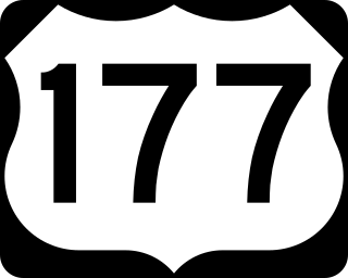
U.S. Route 177 (US-177) is a spur of U.S. Route 77. It currently runs for 233 miles (375 km) from South Haven, Kansas at US-81 to Madill, Oklahoma at US-70. It passes through the states of Kansas and Oklahoma.

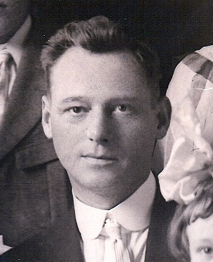
Ernest Whitworth Marland was an American lawyer, oil businessman in Pennsylvania and Oklahoma, and politician who was a U.S. representative and Oklahoma governor. He served in the United States House of Representatives from northern Oklahoma, 1933 to 1935 and as the tenth governor of Oklahoma from 1935 to 1939. As a Democrat, he initiated a "Little Deal" in Oklahoma during the Great Depression, working to relieve the distress of unemployed people in the state, and to build infrastructure as investment for the future.

State Highway 156, abbreviated SH-156, is a highway maintained by the U.S. state of Oklahoma. Spanning 16.91 miles (27.21 km) through the north-central part of the state, it connects the town of Marland, Oklahoma to US-60/US-77/US-177 in the north to US-77 in the west. It is the former alignment of US-77.
Marland Oil Company was an American integrated petroleum company that existed from 1921 to 1929. The company was founded by Ernest Whitworth Marland (1874–1941) and was based in Ponca City, Oklahoma.
John Gruard McCaskey was an American oil businessman.

Lewis Haines Wentz was an American oil businessman.
A. D Buck Museum of Science and History is a museum in Tonkawa, Oklahoma located on the campus of Northern Oklahoma College (NOC).
The Miller Brothers 101 Ranch was a 110,000-acre (45,000 ha) cattle ranch in the Indian Territory of Oklahoma before statehood. Located near modern-day Ponca City, it was founded by Colonel George Washington Miller, a veteran of the Confederate Army, in 1893. The 101 Ranch was the birthplace of the 101 Ranch Wild West Show and one of the early focal points of the oil rush in northeastern Oklahoma. It was the largest diversified farm and ranch in America at the time. Bill Pickett's grave and the White Eagle Monument are located on the ranch grounds. The location of the former working cattle ranch was subdivided and all of its buildings destroyed. An 82-acre (33 ha) area of the ranch is a National Historic Landmark. In 2003, the ranch was inducted into the Texas Trail of Fame.

U.S. Route 60 (US-60) is a transcontinental U.S. highway extending from near Brenda, Arizona to Virginia Beach, Virginia on the Atlantic Ocean. Along the way, 352.39 miles (567.12 km) of the route lies within the state of Oklahoma. The highway crosses into the state from Texas west of Arnett and serves many towns and cities in the northern part of the state, including Arnett, Seiling, Fairview, Enid, Ponca City, Pawhuska, Bartlesville, and Vinita. US-60 exits Oklahoma near Seneca, Missouri. In Oklahoma, US-60 has three business routes, serving Tonkawa, Ponca City, and Seneca. The first 60.2 miles (96.9 km) of the route, from the Texas line to Seiling, is also designated as State Highway 51 (SH-51).

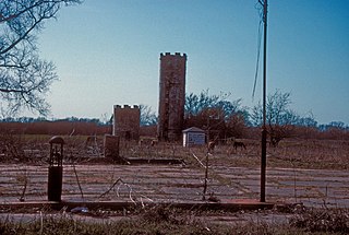
Whizbang, officially called Denoya, was an Oklahoma petroleum boom town in the 1920s and 1930s. Located in Osage County, 1.5 miles north and 1.5 miles west of the present town of Shidler, the Whizbang area at its peak had a population of 10,000 persons and 300 businesses. It was considered the rowdiest of the many oil field towns in Oklahoma.
Dilworth was one of the many oil boomtowns created in Kay County, Oklahoma during the early part of the 20th Century. It was located about 10.5 miles northwest of Newkirk, the county seat, or about 14 miles by present-day roads. While it is now designated a Populated Place, it is considered a ghost town.
References
- 1 2 3 4 5 6 7 8 9 10 11 12 13 14 15 16 "Three Sands: Oklahoma Oil Field and Community of the 1920's" (PDF). Leslie James Gilbert, University of Oklahoma, 1967 (accessed on ShareOK.org). Archived (PDF) from the original on September 24, 2022. Retrieved September 24, 2022.
- ↑ "Tonkawa-Three Sands Field". Oklahoma Historical Society. Archived from the original on September 24, 2022. Retrieved September 24, 2022.
- ↑ "Energy, Northwest Oklahoma, 1910-1930" (PDF). Oklahoma State University, 1986. Archived (PDF) from the original on November 1, 2021. Retrieved September 24, 2022.
- ↑ "Three Sands". The Oklahoman, November 27, 1999. Archived from the original on September 24, 2022. Retrieved September 24, 2022.
- ↑ "Marland to Lio, OK". AbandonedRails.com. Archived from the original on June 8, 2022. Retrieved September 23, 2022.
- ↑ "Cases Disposed of Without Printed Report". 1942. Archived from the original on September 24, 2022. Retrieved September 23, 2022.
- ↑ "Kay County". Oklahoma Historical Society. Archived from the original on April 29, 2022. Retrieved September 24, 2022.