
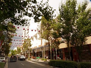
Redfern is an inner southern suburb of Sydney located 3 kilometres (1.9 mi) south of the Sydney central business district and is part of the local government area of the City of Sydney. Strawberry Hills is a locality on the border with Surry Hills. The area experienced the process of gentrification and is subject to extensive redevelopment plans by the state government, to increase the population and reduce the concentration of poverty in the suburb and neighbouring Waterloo.

Port Macquarie is a town on the Mid North Coast of New South Wales, Australia, 390 km (242 mi) north of Sydney, and 570 km (354 mi) south of Brisbane, on the Tasman Sea coast at the mouth of the Hastings River, and the eastern end of the Oxley Highway (B56). It had a population of 47,974 in 2018, and an estimated population of 50,307 in 2023.

Belconnen is a district in the Australian Capital Territory in Australia. The district is subdivided into 27 divisions (suburbs), sections and blocks. As at the 2021 census, the district had a population of 106,061 people; and was the most populous district within the Australian Capital Territory (ACT).

Gunnedah is a town in north-central New South Wales, Australia and is the seat of the Gunnedah Shire local government area. In the 2021 census the town recorded a population of 8,338. Gunnedah is situated within the Liverpool Plains, a fertile agricultural region, with 80% of the surrounding shire area devoted to farming. The Namoi River flows west then north-west through the town providing water beneficial to agricultural operations in the area.

Tarragindi is a southern suburb of the City of Brisbane, Queensland, Australia. It is represented through the Holland Park and Moorooka Ward councillors on the Brisbane City Council. In the 2021 census, Tarragindi had a population of 11,035 people.

Macquarie Fields is a suburb of Sydney, in the state of New South Wales, Australia. Macquarie Fields is located 38 kilometres south-west of the Sydney central business district, in the local government area of the City of Campbelltown and is part of the Macarthur region.

Baulkham Hills is a suburb in the Hills District of Greater Sydney, in the state of New South Wales, Australia. It is located within 30 kilometres (19 mi) north-west of the Sydney central business district mostly within the local government area of The Hills Shire, of which Baulkham Hills was formerly the administrative seat and namesake of The Hills Shire. A small section of the suburb which is located south of the Hills Motorway-Windsor Road intersection is part of the City of Parramatta.

Macquarie Park is a suburb in the Northern Sydney region of Sydney, New South Wales, Australia. Macquarie Park is located 13 kilometres north-west of the Sydney central business district in the local government area of the City of Ryde.
Rouse Hill is a suburb of Sydney, in the state of New South Wales, Australia. Rouse Hill is located in the Hills District, 43 kilometres north-west of the Sydney central business district and 19 kilometres north-west of the Parramatta central business district. It is in the local government areas of The Hills Shire and City of Blacktown. Rouse Hill Town Centre is at the heart of the suburb, which contains a busy Town Square.
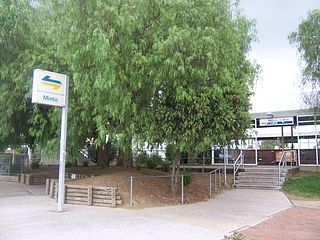
Minto is a suburb of Sydney, in the state of New South Wales, Australia. Minto is located 50 kilometres south-west of the Sydney central business district, in the local government area of the City of Campbelltown and is part of the Macarthur region.

Kellyville is a suburb of Sydney, in the state of New South Wales, Australia 36 kilometres north-west of the Sydney central business district in the local government area of The Hills Shire. It is part of the Hills District region.

Long Point is a suburb of Sydney, in the state of New South Wales, Australia. Long Point is located 46 kilometres south-west of the Sydney central business district, in the local government area of the City of Campbelltown.

Port Macquarie-Hastings Council is a local government area in the Mid North Coast region of New South Wales, Australia.

Wannanup is a residential suburb in Western Australia, located 12 kilometres (7 mi) southwest of Mandurah and 87 kilometres (54 mi) south-southwest of the state capital, Perth. It is surrounded on three sides by water – the Indian Ocean to the west, the Harvey Estuary to the east and the Dawesville Channel to the south – and is home to the Port Bouvard development. It is one of four suburbs which lie on an island created by the building of the Dawesville Channel.
Teneriffe is an inner suburb of Brisbane, Queensland, Australia, 2.5 kilometres (1.6 mi) north-east of the CBD. In the 2021 census, Teneriffe had a population of 5,520 people.

The Ponds is a suburb of Sydney, in the state of New South Wales, Australia. The Ponds is about 40 kilometres (25 mi) west-northwest of the Sydney central business district in the Blacktown local government area. The 2021 census recorded the resident population of The Ponds as 16,315.

Craigburn Farm is a suburb of Adelaide, South Australia, Australia. It is located about 17 km by road south of the city centre.

Paradise Point is a coastal suburb in the City of Gold Coast, Queensland, Australia. In the 2021 census, Paradise Point had a population of 7,062 people.
Sancrox is an industrial area and suburb of Port Macquarie, a city in New South Wales.
Gabbadah is a locality within the Shire of Gingin, located around 30 km north of Perth metropolitan area's northern limit.

