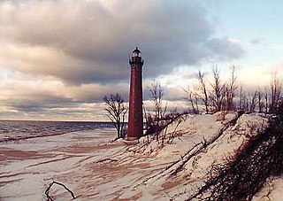
The Lower Peninsula of Michigan – also known as Lower Michigan – is the larger, southern and less elevated of the two major landmasses that make up the U.S. state of Michigan; the other being the Upper Peninsula, which is separated by the Straits of Mackinac. It is surrounded by water on all sides except its southern border, which it shares with Indiana and Ohio. Although the Upper Peninsula is commonly referred to as "the U.P.", it is uncommon for the Lower Peninsula to be called "the L.P."

The Au Sable River is a 138-mile-long (222 km) river in the Lower Peninsula of the U.S. state of Michigan. Rising in the Northern Lower Peninsula, the river flows in a generally southeasterly direction to its mouth at Lake Huron at the communities of Au Sable and Oscoda.It is considered one of the best brown trout fisheries east of the Rockies and has been designated a blue ribbon trout stream by the Michigan Department of Natural Resources. A map from 1795 located in the United States Gazetteer calls it the Beauais River. In French, the river is called the Rivière au sable, literally "Sand River".

Grayling Charter Township is a charter township of Crawford County in the U.S. state of Michigan. The population was 5,642 as of the 2020 census, down from 5,827 at the 2010 census. The city of Grayling is surrounded by Grayling Charter Township, but both are administered autonomously.

Hiawatha National Forest is a 894,836-acre (362,127 ha) National Forest in the Upper Peninsula of the state of Michigan in the United States. Commercial logging is conducted in some areas. The United States Forest Service administers this National Forest; it is physically divided into two subunits, commonly called the Eastside 46°14′N84°50′W and Westside 46°08′N86°40′W.

Yellowstone Lake is the largest body of water in Yellowstone National Park. The lake is 7,732 feet (2,357 m) above sea level and covers 136 square miles (350 km2) with 110 miles (180 km) of shoreline. While the average depth of the lake is 139 ft (42 m), its greatest depth is at least 394 ft (120 m). Yellowstone Lake is the largest freshwater lake above 7,000 ft (2,100 m) in North America.
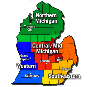
Southern Michigan is a loosely defined geographic area of the U.S. state of Michigan. Southern Michigan may be referred to as a sub-region or component area to other regions of the Lower Peninsula of Michigan. It is an area of rolling farmland, including the Irish Hills. It is usually defined as anywhere less than approximately 45-50 miles North of Ohio/Indiana border, it can also be defined as the bottom two rows of counties of Michigan, meaning any county which borders Ohio or Indiana and the county just north of that. The region shares a state border with Indiana and Ohio. However the actual line is somewhat disputed.
Gull Island is the name of a dozen small islands in the U.S. state of Michigan.
Newfound Lake is located in Grafton County, New Hampshire, United States. It is situated in the Lakes Region of central New Hampshire, in the towns of Alexandria, Bridgewater, Bristol, and Hebron. Its area of 4,451 acres (18.0 km2) places it behind only Lake Winnipesaukee and Squam Lake among lakes located entirely within New Hampshire, and fourth in the state overall, when Umbagog Lake on the Maine border is included.

The Door Peninsula is a peninsula in eastern Wisconsin, separating the southern part of the Green Bay from Lake Michigan. The peninsula includes northern Kewaunee County, northeastern Brown County, and the mainland portion of Door County. It is on the western side of the Niagara Escarpment. Well known for its cherry and apple orchards, the Door Peninsula is a popular tourism destination. With the 1881 completion of the Sturgeon Bay Ship Canal, the northern half of the peninsula became an island.
The Black Mallard River, also known as Carp Creek, is a short river in the Lower Peninsula of the U.S. state of Michigan. The river is approximately 10 miles (16 km) long and flows into Lake Huron about 15 miles (24 km) east of Cheboygan at 45°32′24″N84°07′51″W.

The Escanaba River is a 52.2-mile-long (84.0 km) river on the Upper Peninsula of the U.S. state of Michigan.
The Boyne City Railroad was a railway based at Boyne City, Michigan, U.S., during 1893–1978.
The University of Michigan Biological Station (UMBS) is a research and teaching facility operated by the University of Michigan. It is located on the south shore of Douglas Lake in Cheboygan County, Michigan. The station consists of 10,000 acres (40 km2) of land near Pellston, Michigan in the northern Lower Peninsula of Michigan and 3,200 acres (13 km2) on Sugar Island in the St. Mary's River near Sault Ste. Marie, in the Upper Peninsula. It is one of only 28 Biosphere Reserves in the United States.

The Brule River is a 52.3-mile-long (84.2 km) river in the U.S. states of Michigan and Wisconsin. Nearly, almost all of the course forms a portion of the boundary between the two states.
Skiff Lake is a lake in Canterbury Parish, York County, New Brunswick, Canada.

Boyne River is a stream in Northern Michigan, named for the River Boyne in Leinster, Ireland. Together with the north and south branches, the river system has approximately 22 miles (35 km) of mainstream and the water basin drains 40,320 acres (163.2 km2). Boyne River is Lake Charlevoix's second-largest tributary, after the Jordan River.

Otsego Lake is located in northwest Michigan at 44°57′20″N84°41′32″W, south of the city of Gaylord in Otsego County. The lake spans the boundary between Otsego Lake Township to the south and Bagley Township to the north. Otsego Lake State Park is located on the southeast shore of the lake and Otsego County Park is on the northwest shore. The lake has many private cottages and homes with direct access to the lake and parks.

The Lake Border Moraine is a complex group of moraines bordering the southern end of Lake Michigan. It can be traced north along the eastern shore of the lake basin and across the highlands between the northern Lake Michigan and Saginaw Bay. It continues around the Saginaw Basin into the "thumb" of Michigan, and south through southeastern Michigan on the eastern side of the "thumb." Along Lake Michigan, north to Holland the system is close to the shore. From Holland north to Oceana County it is 15 miles (24 km) to 25 miles (40 km) east of the shore. In Oceana County it forms the prominent "clay banks" along the shoreline of Lake Michigan. It again bears inland from Hart, where more recent moraines reside between it and Lake Michigan. It runs north of the great interlobate moraine that exists between the Lake Michigan and Saginaw lobes of the Laurentian ice sheet. A little north of Cadillac turns to the east. A short distance from Cadillac, it splits with the southern ridge or outer member heading to the Saginaw basin. The northern ridge heads towards Lake Huron, but turns south before reaching the shore. In Newaygo and Lake counties it rest on an earlier interlobate moraine. It separates in Wexford and Missaukee counties to continue south along the west side of the Saginaw basin.
The Maple River, which flows into Burt Lake, is a major river in the northern tip of the Lower Peninsula of the U.S. state of Michigan. The river drains sections of Cheboygan County and Emmet County, and provides an outflow for the 3,395-acre (1,374 ha) Douglas Lake.
Venison Creek is the largest tributary to Big Creek, in the Long Point Region Conservation Area, on the north shore of Lake Erie, in Ontario, Canada.


