Tian Shan montane conifer forests

Last updated
Ecoregion: Tian Shan montane conifer forests
Karakol Canyon (2564381482).jpg
Karakol Canyon, southeast of Lake Issyk-Kul
Ecoregion PA0521.png
Ecoregion territory (in purple)
Ecology
Realm Palearctic
Biome Temperate coniferous forest
Geography
Area24,605 km2 (9,500 sq mi)
Countries
Coordinates 43°30′N84°30′E / 43.500°N 84.500°E / 43.500; 84.500

The Tian Shan montane conifer forests ecoregion (WWF ID: PA0521) covers the "forest belt" of the Tian Shan mountains - generally the north-facing slopes that get enough moisture, and are warm enough, for trees to grow. This conifer belt is found mostly between 1,500 and 2,700 meters. [1] [2]

Contents

Location and description

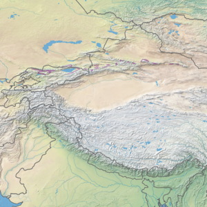
The ecoregion stretches in patches on the main Tian Shan mountain ridge, across approximately 2,000 km from western Kyrgyzstan to eastern Xinjiang Province in China. The conifer forest belt is found on north-facing slopes, at altitudes from a minimum of 1,500 meters (below which it is too dry to support conifers) to a maximum of 2,700 meters (above which it is too cold). The disconnected components of the ecoregion tend to be elongated along ridges that average 4,000 meters in height, with one of the larger sections wrapping around Lake Issyk-Kul. [1] In general, the landscape below the forest belt is steppe, and above is alpine meadow with occasional dwarf junipers.

Climate

The climate of the ecoregion is cold semi-arid (Köppen climate classification (BSk)). This climate is generally characterized as having precipitation greater than a true desert, and also a colder temperature. [3] [4]

Flora and fauna

The dominant conifer in these forests is the Asian spruce ( Picea schrenkiana ), which usually grows in stands of the same species. Aspen is found mixed with the spruce at lower altitudes. Birch, willow, and mountain ash are found at higher altitudes. At lower altitudes within the forest belt, an understory of shrubs, grasses and forbes are found under the tree canopy. [1]

Related Research Articles

<span class="mw-page-title-main">Shushensky Bor National Park</span>

Shushensky Bor National Park consists of two representative forests in the extreme southwest of Siberia, in the northern foothills of the Western Sayan Mountains. The northern section is forest-steppe in character, while the southern section is mountain conifer forest. The southern section is bordered on two sides by the Yenisei river reservoir behind the Sayano-Shushenskaya Dam, the largest hydroelectric dam in Russia. The forest has both high biodiversity value and recreational value for hikers and tourists. It is located in the Shushensky District of Krasnoyarsk Krai.

<span class="mw-page-title-main">Zeya Nature Reserve</span> Nature reserve in Amur Oblast, Russia

Zeya Nature Reserve is a Russian 'zapovednik' located over the mountainous headwaters of the Zeya River, on the eastern end of the Tukuringra Range, where it joins the Dzhagdy, in the Amur Region of the Russian Far East. It was created in part to serve as a "reference plot" for the study of the ecological impact of the Zeya Dam and the Zeya Reservoir which were built in the 1960s and 1970s. The ground cover in the reserve is primarily taiga, of mostly larch and Mongolian oak. The reserve is situated 13 km north of the city of Zeya, in the Zeysky District of Amur Oblast.

<span class="mw-page-title-main">Kuznetsk Alatau Nature Reserve</span> Nature reserve in Kemerovo Oblast, Russia

Kuznetsk Alatau Nature Reserve is a Russian 'zapovednik' on the Kuznetsk Alatau, a mountain ridge in the Altai-Sayan mountain region in southwestern Siberia. The Kuznetsk Alatau consists of several ranges of medium height, between which there are river valleys. The reserve is in the watershed of the Tom River and the Chuly River. It is spread over three districts of Kemerovo Oblast: Tisulsky District, Mezhdurechensky District, and Novokuznetsky District. The reserve was established in 1989 and covers an area of 412,900 ha (1,594 sq mi).

<span class="mw-page-title-main">Kolsay Lakes National Park</span> National park in Kazakhstan

Kolsay Lakes National Park is located on the north slope of the Tian Shan Mountains, southeast Kazakhstan. Often referred to as "Pearls of Tien Shan", the park's main feature are the Kolsay Lakes located between the Raiymbek District and Talgar District of Almaty Region. The scenic Lake Kaindy is also within the park. The park boundary is 120 kilometres (75 mi) southeast of Almaty. Lakes of landslide-tectonic origin, approximately formed in 1887 and 1911 on the Kaindy and Kolsay rivers.

<span class="mw-page-title-main">Zhongar-Alatau National Park</span>

Zhongar-Alatau National Park, also Jungar Alatau, or Dzungurian Alatau, was created in 2010 to protect the unique ecology of the Dzungarian Alatau, an isolated, glaciated mountain range in Kazakhstan, on the southeastern border with China. One stated reason for creating the park is to protect forests of wild fruit trees, including apricots, barberry, cherries, and currants. Approximately 1% of the land area of the park is forested with Sievers Apple trees, which are the progenitors of all cultured apple varieties in the world. The park is 300 km long (west-to-east), and spreads across Aksu District, Sarkand District and Alakol District of Almaty Region, 300 km northeast of the regional city of Almaty.

<span class="mw-page-title-main">Altai montane forest and forest steppe</span> Ecoregion in the Altai Mountains

The Altai montane forest and forest steppe ecoregion covers patches of the subalpine forest belt on the Altai Mountains, crossing the border region where Russia, Kazakhstan, Mongolia and China meet. The region has high biodiversity, as it is located in transition zones between different ecoregions, altitudes, and climate zones. It is in the Palearctic realm, with a Cold semi-arid climate. It covers 35,199,998 km2 (13,590,795 sq mi).

<span class="mw-page-title-main">Sayan montane conifer forests</span> Coniferous forests in Russia and Mongolia

The Sayan montane conifer forests ecoregion covers the mid-elevation levels of the Sayan Mountains, the high mountain range between the taiga of Siberia, Russia to the north, and the steppes of Mongolia to the south. The slopes of the mountains at the mid-altitudes are covered by Temperate coniferous forest. The ecoregion is in the Palearctic realm, with a cold semi-arid climate. It covers 35,741,835 km2 (13,800,000 sq mi).

<span class="mw-page-title-main">Qilian Mountains conifer forests</span> Ecoregion in the Tibetan Plateau

The Qilian Mountains Conifer Forests ecoregion is an ecoregion that consists of a series of isolated conifer forests on the northern slopes of the Qilian Mountain Range, on the northeast edge of the Tibetan Plateau in Qinghai and Gansu provinces of north-central China.

<span class="mw-page-title-main">Helanshan montane conifer forests</span> Ecoregion in the Helan Mountains

The Helanshan montane conifer forests ecoregion covers an isolated, forested mountain range surrounded by desert and semi-arid basins. As such, it has been called a "mountain island in the sky", and supports endemic species of plants and animals. The region supports the endangered Helan Shan pika.

<span class="mw-page-title-main">Tian Shan montane steppe and meadows</span>

The Tian Shan montane steppe and meadows ecoregion covers a 2,000 km long stretch of grasslands of the isolated Tian Shan mountains of Central Asia. It is characterized by high-altitude flat and rolling grasslands.

<span class="mw-page-title-main">Tian Shan foothill arid steppe</span> Ecoregion in the Tian Shan Mountains

The Tian Shan foothill arid steppe ecoregion covers the northern and western approaches to the Tian Shan mountains, centered on Lake Issyk-Kul in Kyrgyzstan. This region receives more moisture from Central Asia, thereby supporting more vegetation and diversity of plant and animal species than the deserts to the south.

<span class="mw-page-title-main">Pamir alpine desert and tundra</span> Ecoregion in the Pamir Mountains

The Pamir alpine desert and tundra ecoregion covers the high plateau of the Pamir Mountains, at the central meeting of the great mountain ranges of Central Asia: Himalaya, Karakoram, Hindu Kush, Kunlun, and Tian Shan. It is a region of relatively high biodiversity due to its central location and high elevation differentials, but it also acts as a barrier between the climate and habitats of north and south Asia.

<span class="mw-page-title-main">Changbai Mountains mixed forests</span> Ecoregion in China and North Korea

The Changbai Mountains mixed forests ecoregion covers the Changbai Mountains and surrounding foothills in China and North Korea. The region features extensive and naturally preserved deciduous and conifer forests. The region exhibits high biodiversity due to its relative isolation, temperate climate with high rainfall, and centrality to central Chinese, Siberian, and European floral communities. In 1979, a significant portion of the ecoregion was designated the Changbaishan Biosphere Reserve by UNESCO.

<span class="mw-page-title-main">Qilian Mountains subalpine meadows</span> Ecoregion in China

The Qilian Mountains subalpine meadows ecoregion covers the high meadows and shrubland of the Qilian Mountains, on the northeastern edge of the Tibetan Plateau in central China. These mountains form a divide between the dry regions of the Gobi Desert to the north, and the Qaidam Basin and the Tibetan Plateau to the south. While the habitat supports populations of marmots, grouse and some rare mammal species, the grasslands of the region are under pressure from over-grazing by domestic livestock.

<span class="mw-page-title-main">Khangai Mountains alpine meadow</span> National park in Mongolia

The Khangai Mountains alpine meadows ecoregion runs along the central ridge of the Khangai Mountains in central Mongolia. The slopes to the north are conifer forests, the lowlands to the south are semi-arid steppe. The Khangai are an "island" mountain range surrounded by lower forest steppe and semi-arid regions of central Mongolia. Most of the region is now protected by Tarvagatai Nuruu National Park and Khangai Nuruu National Park.

<span class="mw-page-title-main">Taiheiyo montane deciduous forests</span> Ecoregion in Japan

The Taiheiyo montane deciduous forests ecoregion stretches for about 700 km (430 mi) along the eastern slopes of the island of Honshu, with some small patches on the southern islands of Shikoku and Kyushu. Lower elevations to the east along the coast are in the Taiheiyo evergreen forests ecoregion; higher elevations to the west are in the Nihonkai montane deciduous forests ecoregion. Characteristic forests are of Japanese beech, stone pine, and spruce.

<span class="mw-page-title-main">Hokkaidō montane conifer forests</span> Ecoregion in Hokkaidō, Japan

The Hokkaido montane conifer forests ecoregion covers the mountainous central regions of Hokkaido Island, the northernmost of Japan's main islands. Forests of spruce and fir thrive in the subalpine, cool climate. On the northeastern edge of the island, the conifer forests extend down to the sea under the influence of the cold Oyashio Current coming down from the north, although logging in recent years has put pressure on these stands.

<span class="mw-page-title-main">Northern Annamites rain forests</span> Ecoregion in the Annamites Range

The Northern Annamites rain forests ecoregion covers the rugged and relatively unexplored northern Annamite Mountains of central Laos and Vietnam. There are high numbers of endemic plant species, and the relative remoteness and isolation of the area supports many rare and endangered animals. Rainfall is somewhat less than the lowland rainforest of the lower elevations in Vietnam, and the temperatures slightly cooler due to the higher elevation.

<span class="mw-page-title-main">East Afghan montane conifer forests</span> Ecoregion on the Afghanistan-Pakistan border

The East Afghan montane conifer forests ecoregion covers a series of unconnected conifer forests along the border between Afghanistan and Pakistan, at elevations of 2,000 metres (6,600 ft) to 3,400 metres (11,200 ft) above sea level. The ecoregion supports the near-threatened Markhor (Capra falconeri chiltanensis), known as the Screw-horned goat, the national animal of Pakistan. The forests of the ecoregion have been heavily thinned for timber.

<span class="mw-page-title-main">Baluchistan xeric woodlands</span> Ecoregion in Pakistan and Afghanistan

The Baluchistan xeric woodlands ecoregion covers the middle elevations of a series of mountain ranges of western Pakistan and northeastern Afghanistan, reaching 1,200 kilometres (750 mi) from the Arabian Sea in the south to the Hindu Kush Mountains and the Himalayas in the north. The characteristic vegetation is xeric (dry) woodlands of shrubs and herbaceous cover. The region has rich biodiversity but relatively few endemic species.

References

  1. 1 2 3 "Tian Shan montane conifer forests". World Wildlife Federation (WWF). Retrieved December 28, 2019.
  2. "Map of Ecoregions 2017". Resolve, using WWF data. Retrieved September 14, 2019.
  3. Kottek, M.; Grieser, J.; Beck, C.; Rudolf, B.; Rubel, F. (2006). "World Map of Koppen-Geiger Climate Classification Updated" (PDF). Gebrüder Borntraeger 2006. Retrieved September 14, 2019.
  4. "Dataset - Koppen climate classifications". World Bank. Retrieved September 14, 2019.