
The Ironbridge Gorge is a deep gorge, containing the River Severn in Shropshire, England. It was first formed by a glacial overflow from the long drained away Lake Lapworth, at the end of the last ice age. The deep exposure of the rocks cut through by the gorge exposed commercial deposits of coal, iron ore, limestone and fireclay, which enabled the rapid economic development of the area during the early Industrial Revolution.

Wenlock Edge is a limestone escarpment near Much Wenlock, Shropshire, England and a site of special scientific interest because of its geology. It is over 19 miles (31 km) long, running southwest to northeast between Craven Arms and Much Wenlock, and is roughly 1,083 feet above sea level. The deciduous woodland which runs along it covers much of the steep slopes of the escarpment and in parts it is very well preserved.
The geology of the county of Shropshire, England is very diverse with a large number of periods being represented at outcrop. The bedrock consists principally of sedimentary rocks of Palaeozoic and Mesozoic age, surrounding restricted areas of Precambrian metasedimentary and metavolcanic rocks. The county hosts in its Quaternary deposits and landforms, a significant record of recent glaciation. The exploitation of the Coal Measures and other Carboniferous age strata in the Ironbridge area made it one of the birthplaces of the Industrial Revolution. There is also a large amount of mineral wealth in the county, including lead and baryte. Quarrying is still active, with limestone for cement manufacture and concrete aggregate, sandstone, greywacke and dolerite for road aggregate, and sand and gravel for aggregate and drainage filters. Groundwater is an equally important economic resource.

Benthall Hall is a 16th-century English country house in Benthall in the town of Broseley, Shropshire, England, and a few miles from the historic Ironbridge Gorge. It retains much of its fine oak interior, and an elaborate 17th-century staircase. It is still occupied by the Benthall family, but has been owned by the National Trust since 1958, and is open to the public every Monday, Tuesday, Wednesday, Saturday, Sunday and Bank Holiday Monday.

The Cheddar Complex is a 441.3-hectare (1,090-acre) biological Site of Special Scientific Interest near Cheddar around the Cheddar Gorge and north east to Charterhouse in the Mendip Hills, Somerset, England, notified in 1952.

Swanpool Wood and Furnace Grove is a 13.59-hectare (33.6-acre) biological Site of Special Scientific Interest, in Gloucestershire in South West England. The site is listed in the 'Forest of Dean Local Plan Review' as a Key Wildlife Site (KWS).

Grass Wood is an ancient woodland of 88 hectares in Wharfedale, North Yorkshire, England, that has an exceptional ground flora of woodland wildflowers.

The Clyde Valley Woodlands National Nature Reserve (NNR) comprises six separate woodland sites in the Clyde Valley region of South Lanarkshire, Scotland. These six sites are located along a 12 km section of the River Clyde and its tributaries, and lie close to built-up areas such as Hamilton and Lanark on the southern outskirts of Greater Glasgow. The sites can be easily accessed by about two million people living in the surrounding urban areas, making the reserve unique amongst Scotland's NNRs, most of which tend to be located in more remote areas. The six sites are:
Lower Wye Gorge is a 65-hectare (160-acre) biological and geological Site of Special Scientific Interest in Gloucestershire, notified in 1954 and renotified 1987. The site includes two Gloucestershire Wildlife Trust nature reserves being Ban-y-gor Wood and Lancaut. The Natural England citation states a revision for Lancaut inclusion.

Upper Wye Gorge is a Site of Special Scientific Interest (SSSI), noted for its biological and geological characteristics, around Symonds Yat in the Wye Valley on the Wales–England border. The site is listed in the "Forest of Dean Local Plan Review" as a Key Wildlife Site (KWS).
Puckham Woods is a 32.38-hectare (80.0-acre) biological Site of Special Scientific Interest in Gloucestershire to the east of Cheltenham near Whittington, notified in 1954. The site is listed in the 'Cotswold District' Local Plan 2001-2011 as a Key Wildlife Site (KWS).
Shorn Cliff And Caswell Woods is a 69.2-hectare (171-acre) biological Site of Special Scientific Interest in Gloucestershire, notified in 1986. The site is listed in the 'Forest of Dean Local Plan Review' as a Key Wildlife Site (KWS).
Siccaridge Wood is a 26.6-hectare (66-acre) nature reserve in Gloucestershire. The site is listed in the ‘Stroud District’ Local Plan, adopted November 2005, Appendix 6 as a Key Wildlife Site (KWS).

The Black Country UNESCO Global Geopark is a geopark in the Black Country, a part of the West Midlands region of England. Having previously been an ‘aspiring Geopark’, it was awarded UNESCO Global Geopark status on 10 July 2020.

Scoska Wood is an IUCN Category IV – habitat or species management area, a British national nature reserve (NNR), and a Site of Special Scientific Interest (SSSI) in Littondale, North Yorkshire, England. It is a managed ancient woodland, known for its ash trees, grasses and moths. It was designated as an SSSI in 1975, and was awarded its IUCN status in 1992.

Eaves Wood is a Site of Special Scientific Interest (SSSI) within the Arnside and Silverdale National Landscape in Lancashire, England. It is located 1 km north of Silverdale. This protected area includes King Williams Hill where there is a monument marking the Golden Jubilee of Queen Victoria's accession to the throne, known as the 'Pepperpot'. This woodland is protected because of the plant species found there and because the red squirrel is found in this woodland.
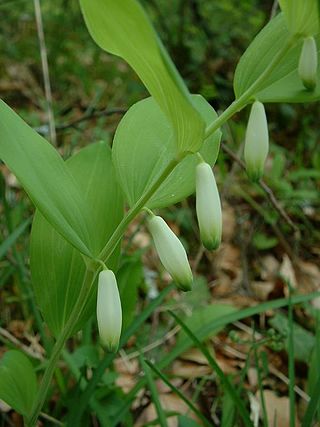
Granham's Moor Quarry is a Site of Special Scientific Interest (SSSI) in Shropshire, England. It is located 1 km southeast of Minsterley within Eastridge Woods. This site of considerable geological importance because the exposed rocks in this protected area show the junction between Cambrian and Ordovician strata.
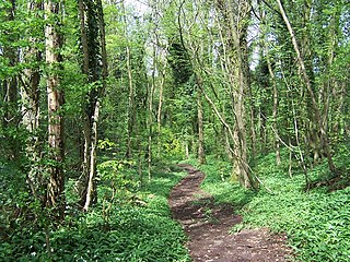
Yarncliff Wood, Padley is a Site of Special Scientific Interest (SSSI) within Peak District National Park in Derbyshire, England. It is located 200m from Nether Padley or 200m from Grindleford Railway Station. This protected area contains a woodland community that once covered much of the edges of upland areas of the Peak District, but is now largely restricted to steep sided valleys. This protected area includes a section of the valley of a stream called Burbage Brook encompassing Padley Gorge.
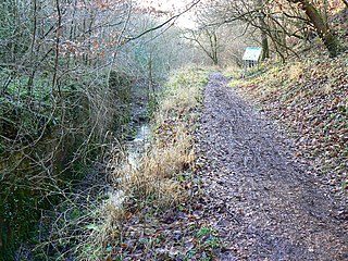
Dove Valley and Biggin Dale is a Site of Special Scientific Interest (SSSI) within Peak District National Park, and contains land in both Derbyshire and Staffordshire, England. It is located 4km north of the town of Ashbourne and encompasses the valley of the River Dove, where it flows through the parish of Eaton and Alsop, past Milldale, towards the village of Thorpe. This valley has exceptional plant and insect diversity including species that live on limestone outcrops or on scree landforms.
