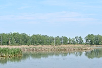
Coyote Hills Regional Park is a regional park encompassing nearly 978 acres of land and administered by the East Bay Regional Park District. The park, which was dedicated to public use in 1967, is located in Fremont, California, US, on the southeast shore of the San Francisco Bay. The Coyote Hills themselves are a small range of hills at the edge of the bay; though not reaching any great height, they afford tremendous views of the bay, three of the trans-bay bridges, the cities of San Francisco and Oakland, the Peninsula Range of the Santa Cruz Mountains and Mount Tamalpais. In addition to the hills themselves, the park encloses a substantial area of wetlands.
Marine Park is a public park located in the neighborhood of Marine Park in Brooklyn, New York. Its 798 acres (3.2 km2) surround the westernmost inlet of Jamaica Bay. Most of the land for Marine Park was donated to New York City to be turned into public park land by the Whitney family in 1920 and by Frederic B. Pratt and Alfred Tredway White, who jointly donated 150 acres (0.61 km2) in 1917. The land donated consists of the area between the current day Fillmore Avenue and Gerritsen Avenue and East 38th Street. Originally almost 2,000 acres (810 ha), over half of which has been donated to the National Park Service as part of the Gateway National Recreation Area, the park is mainly a fertile salt marsh which is supplied with freshwater from Gerritsen Creek.
Many of the public parks and parkways system of Buffalo, New York were originally designed by Frederick Law Olmsted and Calvert Vaux between 1868 and 1896. They were inspired in large part by the parkland, boulevards, and squares of Paris, France. They include the parks, parkways and circles within the Cazenovia Park–South Park System and Delaware Park–Front Park System, both listed on the National Register of Historic Places and maintained by the Buffalo Olmsted Parks Conservancy.

Dyke Marsh is a freshwater wetland and wildlife preserve located on the west bank of the Potomac River south of Alexandria, Virginia between Old Town Alexandria and Mount Vernon. Dyke Marsh consists of about 380 acres (1.5 km2) of tidal marsh, floodplain, and swamp forest. It formed 5,000 to 7,000 years ago. With a total size of 485 acres, Dyke Marsh is one of the largest remaining pieces of freshwater tidal wetlands left in the Baltimore-Washington Metropolitan Area. The marsh is managed by the National Park Service as part of the George Washington Memorial Parkway. Dyke Marsh contains a wide array of plant and animal life. "Haul Road" is a trail that leads visitors into the marsh. It is frequented by area birdwatchers. Dyke Marsh is located off the George Washington Memorial Parkway at the Belle Haven Marina exit.

Horicon Marsh is a marsh located in northern Dodge and southern Fond du Lac counties of Wisconsin. It is the site of both a national and a state wildlife refuge. The silted-up glacial lake is the largest freshwater cattail marsh in the United States.
Erie MetroParks was formed as the "Erie County Metropolitan Park District" in 1968 and adopted its current name in 1991. It consists of 14 individual park areas located throughout Erie County in the US state of Ohio covering approximately 3,200 acres (1,300 ha).
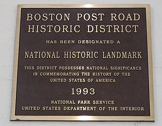
The Boston Post Road Historic District is a 286-acre (116 ha) National Historic Landmark District in Rye, New York, and is composed of five distinct and adjacent properties. Within this landmarked area are three architecturally significant, pre-Civil War mansions and their grounds; a 10,000-year-old Indigenous peoples site and viewshed; a private cemetery, and a nature preserve. It is one of only 11 National Historic Landmark Districts in New York State and the only National Historic Landmark District in Westchester County. It touches on the south side of the nation's oldest road, the Boston Post Road, which extends through Rye. A sandstone Westchester Turnpike marker "24", inspired by Benjamin Franklin's original mile marker system, is set into a wall that denotes the perimeter of three of the contributing properties. The district reaches to Milton Harbor of Long Island Sound. Two of the properties included in the National Park designation are anchored by Greek Revival buildings; the third property is dominated by a Gothic Revival structure that was designed by Alexander Jackson Davis.

Armand Bayou Nature Center is an urban preserve located in Pasadena and southeast Houston between the Johnson Space Center and the Bayport Industrial District. The 2,500-acre (10 km2) nature center is the largest urban wilderness preserve in the United States.

Reinstein Woods Nature Preserve is located near the city of Buffalo in the Town of Cheektowaga in Erie County, New York, USA. Reinstein Woods Nature Preserve is a 292-acre (118 ha) forested complex that also includes wetlands and ponds, located within a developed suburban area. The nature preserve also features an environmental education center.

Kenilworth Park & Aquatic Gardens is a National Park Service site located in the north eastern corner of Washington, D.C., and the near Maryland state border. Nestled near the banks of the Anacostia River and directly west of the Baltimore–Washington Parkway, Kenilworth Park & Aquatic Gardens preserves a plethora of rare waterlilies and lotuses in the cultivated ponds near the river. The park also contains the Kenilworth Marsh, the largest remaining tidal marsh in Washington, D.C., and an adjacent recreational area.

The Louis C. Clark Sanctuary is located on Valentine's Road in Old Brookville in Nassau County, New York on Long Island.

The Palo Alto Baylands Nature Preserve, known officially as the Baylands Nature Preserve, is the largest tract of undisturbed marshland remaining in the San Francisco Bay. Fifteen miles of multi-use trails provide access to a unique mixture of tidal and fresh water habitats. The preserve encompasses 1,940 acres in both Palo Alto and East Palo Alto, and is owned by the city of Palo Alto, California, United States. It is an important habitat for migratory shorebirds and is considered one of the best birdwatching spots on the West Coast.

Theodore Roosevelt State Natural Area is a 265-acre (1.07 km2) North Carolina state park in Carteret County, North Carolina, in the United States. Located on Bogue Banks, in the town of Pine Knoll Shores, the natural area protects the barrier island's only remaining intact maritime forest. It is bounded by NC 58 to the south, Bogue Sound to the north, and private development to the east and west.
Udalls Cove is a marshland and wetland area located in Queens, New York City, off Little Neck Bay between Douglaston and Little Neck Bay. It is one of the few remaining salt marshes on the North Shore in the Metropolitan area; another being the salt marsh southwest of the cove, at Alley Pond Park. For many years, activists and locals have struggled to ensure that these marshlands and wetlands were properly preserved in their natural state by preventing development in the region. These marshlands/wetlands are home to bird and animal life such as muskrats, egrets, and herons, as well as marine life and plants. One of the key agitators to preserve Udall's Cove and its plant and animal Life was Aurora Gareiss, founder of the Udalls Cove Preservation Committee.

Tyrrell Park is a municipal park located in Beaumont, Texas. The park has an area of around 500 acres (2.0 km2). It includes the eighteen hole Henry Homberg Golf Course; the Beaumont Botanical Gardens and Warren Loose Conservatory, the second largest public conservatory in Texas; a hiking trail; an equestrian center; and facilities for several sports and outdoor activities. Adjacent to the park is the 900 acres (4 km2) Cattail Marsh, a nature center with hiking trail. The park is located in a migratory bird flyway and Tyrrell Park is listed on the Great Texas Coastal Birding Trail.
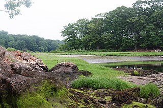
Marshlands Conservancy is a 147-acre nature preserve in the city of Rye, New York, that is fully owned and operated by Westchester County Parks. It has numerous wildlife habitats from ponds to creeks to a large meadow area, succession forest, freshwater wetlands and the only extensive salt marsh in Westchester. It borders Long Island Sound and can be entered via an easement on the historic Boston Post Road. It is one of 5 properties that together constitute the Boston Post Road Historic District. It has high archaeological sensitivity. The conservancy has also been designated an Important Bird Area.
The Hobart Nature District is located in the City of Hobart, Indiana and includes over 1,000 acres (400 ha) of scenic parks, wetlands and floodplains, winding rivers, peaceful lakes, open prairies, oak savannas, old-growth forests, and undulating ravines.
The Fort Worth Nature Center & Refuge is a nature center located between Lakeside and Lake Worth, Texas within Fort Worth, Texas, United States city limits. It consists of prairies, forests, and wetlands. The nature center offers a glimpse of what the Dallas–Fort Worth metroplex looked like before settlement. The center covers 3,621 acres (1,465 ha) and includes over 20 miles (32 km) of hiking trails. It is one of the largest city-owned nature centers in the United States.