
The country of Brazil occupies roughly half of South America, bordering the Atlantic Ocean. Brazil covers a total area of 8,514,215 km2 (3,287,357 sq mi) which includes 8,456,510 km2 (3,265,080 sq mi) of land and 55,455 km2 (21,411 sq mi) of water. The highest point in Brazil is Pico da Neblina at 2,994 m (9,823 ft). Brazil is bordered by the countries of Argentina, Bolivia, Colombia, Guyana, Paraguay, Peru, Suriname, Uruguay, Venezuela, and France.

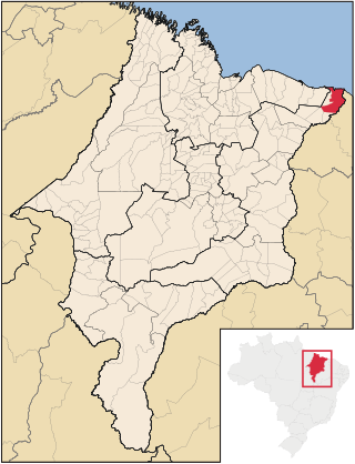
Maranhão is a state in Brazil. Located in the country's Northeast Region, it has a population of about 7 million and an area of 332,000 km2 (128,000 sq mi). Clockwise from north, it borders on the Atlantic Ocean for 2,243 km and the states of Piauí, Tocantins and Pará. The people of Maranhão have a distinctive accent inside the common Northeastern Brazilian dialect. Maranhão is described in books such as The Land of the Palm Trees by Gonçalves Dias and Casa de Pensão by Aluísio Azevedo.

Ceará is one of the 26 states of Brazil, located in the northeastern part of the country, on the Atlantic coast. It is the eighth-largest Brazilian State by population and the 17th by area. It is also one of the main tourist destinations in Brazil. The state capital is the city of Fortaleza, the country's fourth most populous city. The state has 4.3% of the Brazilian population and produces 2.1% of the Brazilian GDP.

Piaui is one of the states of Brazil, located in the country's Northeast Region. The state has 1.6% of the Brazilian population and produces 0.7% of the Brazilian GDP.

Teresina is the capital and most populous municipality in the Brazilian state of Piauí. Being located in north-central Piauí 366 km from the coast, it is the only capital in the Brazilian Northeast that is not located on the shores of the Atlantic Ocean. With 871,126 inhabitants, Teresina is the 21st largest city in Brazil, and the 15th largest state capital in the country. Together with Timon in the nearby state of Maranhão, it forms a conurbation with a population of about 978,734 inhabitants; the entire metropolitan region of Teresina has over 1,226,509 inhabitants. The only natural barrier that separates Teresina from Timon is the Parnaíba river, one of the largest in the Northeast.

Crato is a city of 130,000 inhabitants on the banks of the river Granjeiro in the south of the state of Ceará, in the northeast of Brazil. It was founded on June 21, 1764 by the Capuchin friar Carlos Maria de Ferrara. Originally it was a small village in which the population were principally native Kariris, it gained official status as a city on October 17, 1817.
Barroquinha is a community in the Brazilian state of Ceará. The population was estimated at 15,044 in 2020.
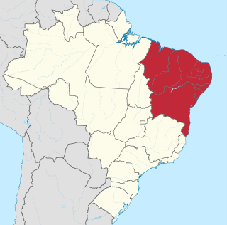
The Northeast Region of Brazil is one of the five official and political regions of the country according to the Brazilian Institute of Geography and Statistics. Of Brazil's twenty-six states, it comprises nine: Maranhão, Piauí, Ceará, Rio Grande do Norte, Paraíba, Pernambuco, Alagoas, Sergipe and Bahia, along with the Fernando de Noronha archipelago.
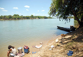
The Parnaíba River is a river in Brazil, which forms the border between the states of Maranhão and Piauí. Its main course is 1,400 km (870 mi) long and the Parnaíba River Basin covers 344,112 km2 (132,862 sq mi). The Parnaíba River rises in the Chapada das Mangabeiras range, and flows northeastward to empty into the Atlantic Ocean, being the longest river entirely located within Brazil's Northeast Region. The middle and upper regions of this river are separated by the Portuguese: Boa Esperança Hydroelectric Power Plant dam, but is otherwise navigable.

Parnaíba is a city in the Brazilian state of Piauí. Having a population of over 150,000 inhabitants according to IBGE's 2020 report, it is the second most populous city in the state, after the capital Teresina. It is one of the four coastal municipalities in Piauí.
Ubatuba is a Brazilian municipality, located on the southeast coast, in the state of São Paulo. It is part of the Metropolitan Region of Vale do Paraíba e Litoral Norte. The population is 92,819 in an area of 723.88 km², of which 83% is located in the Serra do Mar State Park.

Parnaíba–Prefeito Dr. João Silva Filho International Airport is the airport serving Parnaíba, Brazil. It is informally known as Santos Dumont Airport because of its architectonical similarities with Santos Dumont Airport in Rio de Janeiro. It is named after a former mayor of Parnaíba.
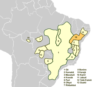
The Karirí languages, generally considered dialects of a single language, were a group of languages formerly spoken by the Kiriri people of Brazil. It was spoken until the middle of the 20th century; the 4,000 ethnic Kiriri are now monolingual Portuguese speakers, though a few know common phrases and names of medicinal plants.
Araioses is the easternmost city in the Brazilian state of Maranhão. It lies near the Parnaíba River's delta, and its territory also include the Canárias, Desgraça, Coroatá and Grande de Paulino islands, apart from several smaller islands.

The coastline of Brazil measures 7,491 km, which makes it the 16th longest national coastline of the world. All the coast lies adjacent to the Atlantic Ocean.
The Ubatuba River is a river of Ceará state in eastern Brazil.

Chaval is a municipality in the state of Ceará in the Northeast region of Brazil.

The Delta do Parnaíba Environmental Protection Area is a federally-administered environmental protection area that covers parts of the coasts of the states of Maranhão, Piauí and Ceará, Brazil.
