
René-Robert Cavelier, Sieur de La Salle, was a 17th-century French explorer and fur trader in North America. He explored the Great Lakes region of the United States and Canada, and the Mississippi River. He is best known for an early 1682 expedition in which he canoed the lower Mississippi River from the mouth of the Illinois River to the Gulf of Mexico; there, on 9 April 1682, he claimed the Mississippi River basin for France after giving it the name La Louisiane, in honor of Saint Louis and Louis XIV. One source states that "he acquired for France the most fertile half of the North American continent". A later ill-fated expedition to the Gulf coast of Mexico gave the United States a claim to Texas in the purchase of the Louisiana Territory from France in 1803. La Salle was assassinated in 1687 during that expedition.
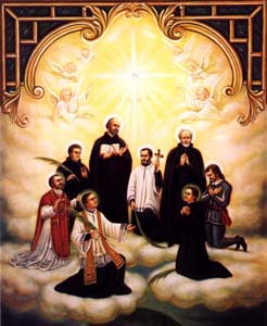
The Canadian Martyrs, also known as the North American Martyrs, were eight Jesuit missionaries from Sainte-Marie among the Hurons. They were ritually tortured and killed on various dates in the mid-17th century in Canada, in what is now southern Ontario, and in upstate New York, during the warfare between the Iroquioan tribes the Mohawk and the Huron. They have subsequently been canonized and venerated as martyrs by the Catholic Church.
Étienne Brûlé was the first European explorer to journey beyond the St. Lawrence River into what is now known as Canada. He spent much of his early adult life among the Hurons, and mastered their language and learned their culture. Brûlé became an interpreter and guide for Samuel de Champlain, who later sent Brûlé on a number of exploratory missions, among which he is thought to have preceded Champlain to the Great Lakes, reuniting with him upon Champlain's first arrival at Lake Huron. Among his many travels were explorations of Georgian Bay and Lake Huron, as well as the Humber and Ottawa Rivers. Champlain agreed to send Brûlé, at his own request, as an interpreter to live among the Onontchataron, an Algonquin people, in 1610. In 1629, during the Anglo-French War, he escaped after being captured by the Seneca tribe. Brûlé was killed and eaten by the Bear tribe of the Huron people, who believed he had betrayed them to the Seneca.

Georgian Bay is a large bay of Lake Huron, in the Laurentia bioregion. It is located entirely within the borders of Ontario, Canada. The main body of the bay lies east of the Bruce Peninsula and Manitoulin Island. To its northwest is the North Channel.

Ancaster is a community in the city of Hamilton in the Canadian province of Ontario. Founded in 1792, it immediately developed itself into one of the first significant and influential early British Upper Canada communities established during the late 18th century, eventually amalgamating with the city of Hamilton in 2001. By 1823, due to its accessible waterpower and location at the juncture of prehistoric trading routes, Ancaster had become Upper Canada's largest industrial and commercial centre. Additionally, Ancaster had at that time attracted the 2nd largest populace (1,681) in Upper Canada, trailing only Kingston, but surpassing the populations of nearby Toronto (1,376) and Hamilton (1,000).

The Beaver Wars, also known as the Iroquois Wars or the French and Iroquois Wars, were a series of conflicts fought intermittently during the 17th century in North America throughout the Saint Lawrence River valley in Canada and the Great Lakes region which pitted the Iroquois against the Hurons, northern Algonquians and their French allies. As a result of this conflict, the Iroquois destroyed several confederacies and tribes through warfare: the Hurons or Wendat, Erie, Neutral, Wenro, Petun, Susquehannock, Mohican and northern Algonquins whom they defeated and dispersed, some fleeing to neighbouring peoples and others assimilated, routed, or killed.

The Grand River, formerly known as the River Ouse, is a large river in Ontario, Canada. It lies along the western fringe of the Greater Golden Horseshoe region of Ontario which overlaps the eastern portion of southwestern Ontario, sometimes referred to as Midwestern Ontario, along the length of this river. From its source near Wareham, Ontario, it flows south through Grand Valley, Fergus, Elora, Waterloo, Kitchener, Cambridge, Paris, Brantford, Ohsweken, Six Nations of the Grand River, Caledonia, and Cayuga before emptying into the north shore of Lake Erie south of Dunnville at Port Maitland. One of the scenic and spectacular features of the river is the falls and Gorge at Elora.

Flamborough is a community in the city of Hamilton in the Canadian province of Ontario. Prior to its amalgamation in 2001, Flamborough comprised the former townships of East Flamborough, West Flamborough, and Beverly, as well as the village of Waterdown. The largest suburban community is the former village of Waterdown, containing one third of the population. Other Flamborough communities include Carlisle, Christie's Corners, Clappison's Corners, Copetown, Freelton, Greensville, Lynden, Kirkwall, Millgrove, Mountsberg, Orkney, Peters Corners, Rockton, Troy, Sheffield, Valens, Strabane and Westover.
Wentworth County, area 269,057 acres (1,089 km2), is a historic county in the Canadian province of Ontario.
Teiaiagon was an Iroquoian village on the east bank of the Humber River in what is now the York district of Toronto, Ontario, Canada. It was located along the Toronto Carrying-Place Trail. The site is near the current intersection of Jane Street and Annette Street, at which is situated the community of Baby Point.

Waterdown is a community in the city of Hamilton in the Canadian province of Ontario. Waterdown is approximately 60 km west of downtown Toronto and, as of 2021, has a population of approximately 24,400 residents.

Jacques-René de Brisay, Marquis de Denonville was the Governor General of New France from 1685 to 1689 and was an important figure during the intermittent conflict between New France and the Iroquois known as the Beaver Wars.

Westdale is a residential neighbourhood in Hamilton, Ontario, Canada. It is centred in the Westdale Village shopping district and located near McMaster University. It is bordered to the north by Cootes Paradise, an extensive nature reserve marking the western end of Lake Ontario, to the south by Main Street and Ainslie Wood, to the east by Highway 403, and to the west by McMaster University.

Ganondagan State Historic Site, also known as Boughton Hill, is a Native American historic site in Ontario County, New York in the United States. Location of the largest Seneca village of the 17th century, the site is in the present-day Town of Victor, southwest of the Village of Victor. The village was also referred to in various spellings as Gannagaro, Canagora, Gandagora, Gandagaro and Gannontaa.
Madeleine de Roybon d'Allonne was an early settler of New France. She was the first European woman to own land in Ontario. There is a memorial plaque in her honour located in Lennox and Addington County.
René Bréhant de Galinée was a member of the Society of Saint-Sulpice at Montreal and an explorer and missionary to the Native Americans. In 1670, he and François Dollier de Casson were the first Europeans to make a recorded transit of the Detroit River. His map of the trip demonstrated that the Great Lakes were all connected.
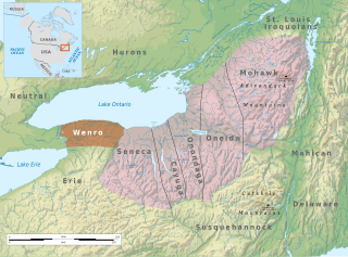
The Wenrohronon or Wenro people were an Iroquoian indigenous nation of North America, originally residing in present-day western New York, who were conquered by the Confederation of the Five Nations of the Iroquois in two decisive wars between 1638–1639 and 1643. This was likely part of the Iroquois Confederacy campaign against the Neutral people, another Iroquoian-speaking tribe, which lived across the Niagara River. This warfare was part of what was known as the Beaver Wars, as the Iroquois worked to dominate the lucrative fur trade. They used winter attacks, which were not usual among Native Americans, and their campaigns resulted in attrition of both the larger Iroquoian confederacies, as they had against the numerous Huron.
Bead Hill is an archaeological site comprising the only known remaining and intact 17th-century Seneca site in Canada. It is located on the banks of the Rouge River in Rouge Park, a national park in Toronto, Ontario. Because of its sensitive archaeological nature, it is not open to the public, nor readily identified in the park. It was designated a National Historic Site in 1991, eventually becoming a unit of the national park system in June 2019.
Ganneious, also spelled Ganneous, is a former village, first settled by the Oneida, located on the North Shore of Lake Ontario near the present site of Napanee, Ontario, Canada. Starting in 1696, it was occupied by the Mississauga.:10 The name is most likely a likely misprint for the French "Gannejout(s)", meaning Oneida.
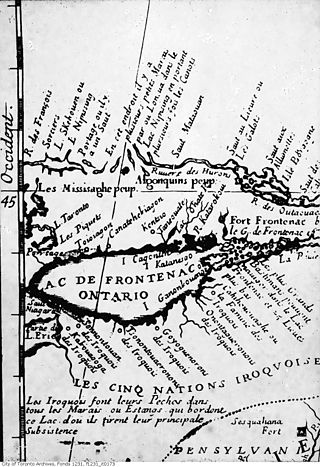
Between 1665 and 1670, seven Iroquois settlements on the north shore of Lake Ontario in present-day Ontario, collectively known as the "Iroquois du Nord" villages, were established by Senecas, Cayugas, and Oneidas. The villages consisted of Ganneious, Kente, Kentsio, Ganaraske, Ganatsekwyagon, Teiaiagon, and Quinaouatoua. The villages were all abandoned by 1701.

