
Dhaulagiri, located in Nepal, is the seventh highest mountain in the world at 8,167 metres (26,795 ft) above sea level, and the highest mountain within the borders of a single country. It was first climbed on 13 May 1960 by a Swiss-Austrian-Nepali expedition. Annapurna I is 34 km (21 mi) east of Dhaulagiri. The Kali Gandaki River flows between the two in the Kaligandaki Gorge, said to be the world's deepest. The town of Pokhara is south of the Annapurnas, an important regional center and the gateway for climbers and trekkers visiting both ranges as well as a tourist destination in its own right.

Mont Forel is a mountain in King Christian IX Land, Sermersooq Municipality, Greenland. It is part of the Schweizerland range, also known as 'Schweizerland Alps'.

The Watkins Range is Greenland's highest mountain range. It is located in King Christian IX Land, Sermersooq municipality.
Tasermiut Fjord is a 70-kilometre-long fjord in southwestern Greenland. Administratively it is part of the Kujalleq municipality. Nanortalik Island is located near the mouth of the fjord.
Lindenow Fjord or Kangerlussuatsiaq, is a fjord in the King Frederick VI Coast, Kujalleq municipality, southern Greenland.

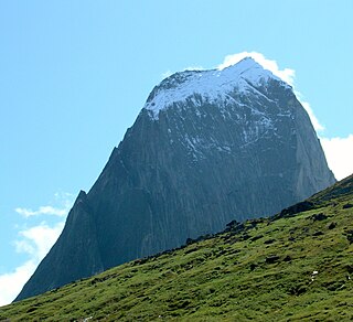
The Nalumasortoq or Naluumasortoq is a 2,045 meter high mountain in southern Greenland, in the Kujalleq municipality.
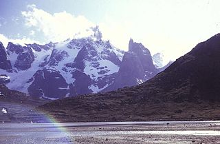
The Ketil is a 2,010 m–high mountain in southern Greenland, in the Kujalleq municipality.
Kangiqtualuk Uqquqti formerly Sam Ford Fiord is an isolated, elongated Arctic fjord on Baffin Island's northeastern coast in the Qikiqtaaluk Region of Nunavut, Canada. The Inuit settlement of Pond Inlet is 320 km (200 mi) to the northwest and Clyde River is 80 km (50 mi) to the east.
Thorland is a peninsula in the King Frederick VI Coast, southeastern Greenland. It is a part of the Sermersooq municipality.
Paatusoq, mentioned as 'Patursok' by Wilhelm August Graah, is a fjord in the King Frederick VI Coast, Kujalleq municipality, southeastern Greenland. Its name means "The one with the big mouth" in the Greenlandic language.
Nattoralik, old spelling Nagtoralik, is a fjord in the King Frederick VI Coast, Kujalleq municipality, southern Greenland.
Alleruusakasiit, former spelling Agdlerussakasit, is a mountain in the Kujalleq municipality, southern Greenland.
Angiartarfik, former spelling Angîârtarfik, is a mountain in the Kujalleq municipality, southern Greenland.

Mount Paatusoq, also known as 'Mount Patuersoq', is the highest mountain in the Kujalleq municipality, SE Greenland.

The Stauning Alps are a large system of mountain ranges in Scoresby Land, King Christian X Land, northeastern Greenland. Administratively the Stauning Alps are part of the Northeast Greenland National Park zone.
Payer Peak, is a mountain in King Christian X Land, Northeast Greenland. Administratively it is part of the Northeast Greenland National Park zone.
Petermann Peak,, also known as Petermann Fjeld, Petermanns Topp and Petermann Point is a mountain in King Christian X Land, Northeast Greenland. Administratively it is part of the Northeast Greenland National Park zone.

Schweizerland, also known as Schweizerland Alps, is a mountain range in King Christian IX Land, eastern Greenland. Administratively this range is part of the Sermersooq Municipality. Its highest point is one of the highest peaks in Greenland.

The Lemon Range or Lemon Mountains is a mountain range in King Christian IX Land, eastern Greenland. Administratively this range is part of the Sermersooq Municipality.
