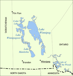
Lake Winnipeg is a very large, relatively shallow 24,514-square-kilometre (9,465 sq mi) lake in North America, in the province of Manitoba, Canada. Its southern end is about 55 kilometres (34 mi) north of the city of Winnipeg. Lake Winnipeg is Canada's sixth-largest freshwater lake and the third-largest freshwater lake contained entirely within Canada, but it is relatively shallow excluding a narrow 36 m (118 ft) deep channel between the northern and southern basins. It is the eleventh-largest freshwater lake on Earth. The lake's east side has pristine boreal forests and rivers that were in 2018 inscribed as Pimachiowin Aki, a UNESCO World Heritage Site. The lake is 416 km (258 mi) from north to south, with remote sandy beaches, large limestone cliffs, and many bat caves in some areas. Manitoba Hydro uses the lake as one of the largest reservoirs in the world. There are many islands, most of them undeveloped.
Beaver Creek may refer to:

The Souris River or Mouse River is a river in central North America. It is about 700 km (430 mi) in length and drains about 23,600 square miles (61,100 km2). It rises in the Yellow Grass Marshes north of Weyburn, Saskatchewan. It wanders south through North Dakota beyond Minot to its most southern point at the city of Velva, and then back north into Manitoba. The river passes through the communities of Melita, Hartney, Souris and Wawanesa and on to its confluence with the Assiniboine River near Treesbank, about 25 miles (40 km) southeast of Brandon. The main tributaries which flow into the Souris in Manitoba are the Antler River, the Gainsborough, and Plum Creeks.
The Winnipeg River is a Canadian river that flows roughly northwest from Lake of the Woods in the province of Ontario to Lake Winnipeg in Manitoba. This river is 235 kilometres (146 mi) long from the Norman Dam in Kenora to its mouth at Lake Winnipeg. Its watershed is 106,500 square kilometres (41,100 sq mi) in area, mainly in Canada. About 29,000 square kilometres (11,000 sq mi) of the watershed is in northern Minnesota, United States.
Souris is an unincorporated urban community in the Municipality of Souris – Glenwood within the Canadian province of Manitoba that held town status prior to January 1, 2015. It is located within the municipality at the confluence of Plum Creek and Souris River, from which it takes its name. Before 1882, the town was called Plum Creek. The community is home to Canada's longest historic cable-stayed footbridge (177 m [581 ft]), known as the Swinging Bridge, which spans the Souris River that divides the community. The Swinging Bridge was built in 1904 as a means of transportation over the Souris River. Residents of Souris are referred to as Sourisites.

The Hayes River is a river in Northern Manitoba, Canada, that flows from Molson Lake to Hudson Bay at York Factory. It was historically an important river in the development of Canada and is now a Canadian Heritage River and the longest naturally flowing river in Manitoba.

Melita is a town located in the south-western corner of the Canadian province of Manitoba. It is surrounded by the Municipality of Two Borders and occupies a bend of the Souris River. Graham Creek runs along the west side of town and into the Souris River. The population at the 2016 census was 1,042. It sits at the junction of Highways 3 and 83, approximately 320 km southwest of Winnipeg. Melita is known as the "Grasslands Bird Capital of Manitoba" and is located in Manitoba's banana belt.
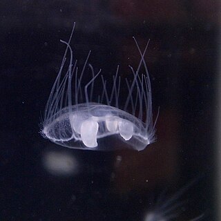
Craspedacusta sowerbii or peach blossom jellyfish is a species of freshwater hydrozoan jellyfish, or hydromedusa cnidarian. Hydromedusan jellyfish differ from scyphozoan jellyfish because they have a muscular, shelf-like structure called a velum on the ventral surface, attached to the bell margin. Originally from the Yangtze basin in China, C. sowerbii is an invasive species now found throughout the world in bodies of fresh water.
Treaty 2 was entered in to on 21 August 1871 at Manitoba House, Rupertsland, with representatives of the Queen of Great Britain and Ireland. The original Anishinaabe, who were present, constitute Treaty 2 today. It is known that many of the chiefs and leaders within the territory were at the early gathering and after the treaty was agreed to. Those who were not present were represented through Metis until they indicated where they wished their farming reserves to be established. The treaty reaffirmed the inherent rights that the Anishinaabe had prior to European contact, located where southwestern Manitoba is today and a small part of southeastern Saskatchewan.

The Rural Municipality of Sifton is a rural municipality (RM) in the south-west portion of the Canadian province of Manitoba.

Division No. 19, also informally known as North East Manitoba, is a census division within the Province of Manitoba, Canada. Unlike in some other provinces, census divisions do not reflect the organization of local government in Manitoba. These areas exist solely for the purposes of statistical analysis and presentation; they have no government of their own.

Spruce Woods Provincial Park is located in south-central Manitoba, Canada where the Assiniboine River passes through the delta of sediment left by the last glaciation. An area of open and stabilized sand dunes within the park provides habitat to species of plants and animals not found elsewhere in Manitoba. In descending order of land area contained, the park lies within the Rural Municipalities of South Cypress, Victoria, and North Cypress.
The Rural Municipality of Shell River was a rural municipality (RM) in the Canadian province of Manitoba. It was incorporated as a rural municipality on December 22, 1883. On January 1, 2015 it was amalgamated as a result a provincial government mandate with the RM of Hillsburg and the Town of Roblin to form the Municipality of Hillsburg – Roblin – Shell River.

The Mistik Creek is a stream in the Hudson Bay drainage basin in the Northern Region of Manitoba, Canada, approximately 20 kilometres (12 mi) northeast of Bakers Narrows.
The Municipality of Roblin is a rural municipality (RM) in the Parkland Region of Manitoba, Canada.

Netley Creek Provincial Park is a Manitoba provincial park on the west shore of the Red River north of Selkirk, Manitoba at the mouth of Netley Creek. It provides visitors with access to these waterways and adjacent Netley-Libau Marsh.
Oak Lake is a lake in the south-western part of the Canadian province of Manitoba in a region called Westman. Oak Lake is a kettle lake and is an aquifer supplier for numerous nearby residential areas and farms. The lake is in the RM of Sifton and sits at an elevation of 426 metres above sea level. Provincial Road 254 provides access to the lake.
The Red Deer River is a river in the Canadian provinces of Saskatchewan and Manitoba. It has its source at Nut Lake in east central Saskatchewan and from there, it flows east towards Manitoba where it empties into Dawson Bay of Lake Winnipegosis. To the north of Red Deer's basin is the Saskatchewan River, to the south-west is the upper Assiniboine River, and to the south-east is Swan River.
Woody River is a river in the Canadian provinces of Manitoba and Saskatchewan. The river's source is in the Porcupine Hills and Porcupine Provincial Forest of eastern Saskatchewan. From there it flows south through boreal forest and then east through Boreal Plains in the Parkland Region of Manitoba en route to Swan Lake. The river parallels the Swan River for much of its route as it travels through Swan River Valley between Duck Mountain and Porcupine Hills of the Manitoba Escarpment. Bowsman is the only notable community along the course of Woody River. Several highways cross it, including Saskatchewan's Highway 980, Manitoba's Roads 588, 587, 366, 268, and Manitoba's Highway 10.

