The Lower Peninsula of Michigan – also known as Lower Michigan – is the larger, southern and less elevated of the two major landmasses that make up the U.S. state of Michigan; the other being the Upper Peninsula, which is separated by the Straits of Mackinac. It is surrounded by water on all sides except its southern border, which it shares with Indiana and Ohio. Although the Upper Peninsula is commonly referred to as "the U.P.", it is uncommon for the Lower Peninsula to be called "the L.P."

Tuscola County is a county in the Thumb region of the U.S. state of Michigan. As of the 2020 census, the population was 53,323. The county seat is Caro. The county was created by Michigan Law on April 1, 1840, from land in Sanilac County and attached to Saginaw County for administrative purposes. The Michigan Legislature passed an act on March 2, 1850, that empowered the county residents to organize governmental functions.

Saginaw County, officially the County of Saginaw, is a county located in the U.S. state of Michigan. As of the 2020 Census, the population was 190,124. The county seat is Saginaw. The county was created by September 10, 1822, and was fully organized on February 9, 1835. The etymology of the county's name is uncertain. It may be derived from Sace-nong or Sak-e-nong, as the Sauk tribe is believed by some to have once lived there. A more likely possibility is that it comes from Ojibwe words meaning "place of the outlet" –sag and ong. See List of Michigan county name etymologies.

Huron County is a county in the U.S. state of Michigan. As of the 2020 Census, the population was 31,407. The county seat is Bad Axe. Huron County is at the northern tip of the Thumb, which is a sub region of Mid Michigan. It is a peninsula, bordered by Saginaw Bay to the west and Lake Huron to the north and east, and has over 90 miles (140 km) of shoreline, from White Rock on Lake Huron to Sebewaing on the Saginaw Bay. Huron County's most important industry is agriculture, as with most of the other Thumb counties. Huron County enjoys seasonal tourism from large cities such as Detroit, Flint, and Saginaw. A lot of the tourism is in the Port Austin and Caseville area.

Fairhaven Township is a civil township of Huron County in the U.S. state of Michigan. The population was 1,259 at the 2000 census.
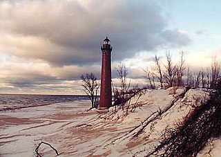
Tawas City is a city along Lake Huron in the Lower Peninsula of the U.S. state of Michigan. The population was 1,827 at the 2010 census. It is the county seat of Iosco County. The city is adjacent to Tawas Township but is administratively autonomous.
M-25 is a state trunkline highway in the US state of Michigan. The route follows an arc-like shape closely along the Lake Huron shore of the Thumb in the eastern Lower Peninsula between Port Huron and Bay City. It serves the lakeshore resorts along Lake Huron and Saginaw Bay and generally lies within sight of the lake and the bay. All is surface road and generally scenic, except for the freeway segment near the junction with Interstate 75 (I-75) and connection into the US Highway 10 (US 10) freeway.
The Thumb is a region and a peninsula of the U.S. state of Michigan, so named because the Lower Peninsula is shaped like a mitten. The Thumb area is generally considered to be in the Central Michigan region, east of the Tri-Cities and north of Metro Detroit. The region is also branded as the Blue Water Area.
Gull Island is the name of a dozen small islands in the U.S. state of Michigan.

Saginaw Bay is a bay within Lake Huron located on the eastern side of the U.S. state of Michigan. It forms the space between Michigan's Thumb region and the rest of the Lower Peninsula of Michigan. Saginaw Bay is 1,143 square miles (2,960 km2) in area. It is located in parts of five Michigan counties: Arenac, Bay, Huron, Iosco, and Tuscola.

Pine River may refer to any of the following rivers in the U.S. state of Michigan:

The Flint River is a 78.3-mile-long (126.0 km) river in the Flint/Tri-Cities region of Michigan in the United States. The river's headwaters are in Columbiaville in Lapeer County and flows through the counties of Lapeer, Genesee, and Saginaw. The cities of Lapeer, Flint, Flushing, and Montrose are along its course.
The Cass River is a 61.5-mile-long (99.0 km) river in the Thumb region of the U.S. state of Michigan. It drains large portions of Sanilac and Tuscola counties and smaller portions of Genesee, Huron, Lapeer, and Saginaw counties.

The Shiawassee River in the U.S. state of Michigan drains an area of 1,201 square miles (3,110 km2) within Oakland, Genesee, Livingston, Shiawassee, Midland and Saginaw counties. It flows in a generally northerly direction for about 110 miles (180 km) from its source to its confluence with the Tittabawassee River creating the Saginaw River, which drains into the Saginaw Bay of Lake Huron.

Central Michigan, also called Mid Michigan, is a region in the Lower Peninsula of the U.S. state of Michigan. As its name implies, it is the middle area of the Lower Peninsula. Lower Michigan is said to resemble a mitten, and Mid Michigan corresponds roughly to the thumb and palm, stretching from Michigan's eastern shoreline along Lake Huron into the fertile rolling plains of the Michigan Basin. The region contains cities of moderate size, including Flint, Saginaw, and the state capital of Lansing.
US Highway 23 (US 23) is a north–south United States Numbered Highway that runs from Jacksonville, Florida, to Mackinaw City, Michigan. In the US state of Michigan, it is a major, 362-mile-long (583 km), north–south state trunkline highway that runs through the Lower Peninsula. The trunkline is a freeway from the Michigan–Ohio state line near Lambertville to the city of Standish, and it follows the Lake Huron shoreline from there to its northern terminus. Serving the cities of Ann Arbor and Flint, US 23 acts as a freeway bypass of the Metro Detroit area. Overall, the highway runs through rural areas of the state dominated by farm fields or woodlands; some segments are urban in character in the Ann Arbor, Flint and Tri-Cities areas. The section from Flint north to Standish also carries Interstate 75 (I-75) along a concurrency that includes a segment that carries almost 70,000 vehicles on a daily basis.

Water and Woods Field Service Council was a field service council of the Michigan Crossroads Council that served youth in the central and northeastern Lower Peninsula of Michigan. The Council was headquartered in Flint, Michigan, with service centers located in Auburn, Lansing, and Port Huron. The Water and Woods Field Service Council was the result of a merger in 2012 of Lake Huron Area Council, Blue Water Council, Tall Pine Council and Chief Okemos Council.

The Shiawassee River Heritage Water Trail started as a 7 miles (11 km) water trail in the Shiawassee River, within Genesee County and Oakland County, Metro Detroit, southeastern Michigan. It now reaches 85.5 85.5 miles (137.6 km) from Holly to Chesaning in Saginaw County.
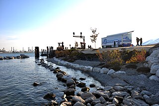
The Blue Water River Walk is a nearly one mile stretch of land along the St. Clair River in Port Huron, Michigan. The River Walk begins just south of the mouth of the Black River and continues to the Seaway Terminal. It is less than a mile south of the Blue Water Bridge to Sarnia and the southern end of Lake Huron. The Blue Water River Walk includes a naturalized shoreline made up of natural rocks, boulders and pebbles. Native plants, flowers, trees and shrubs growing in a natural landscape make up the habitat onshore. The River Walk provides a place for natural habitat to thrive and for visitors to take a walk along the shoreline and enjoy looking for turtles, having a picnic, and watching freighters.

The Lake Border Moraine is a complex group of moraines bordering the southern end of Lake Michigan. It can be traced north along the eastern shore of the lake basin and across the highlands between the northern Lake Michigan and Saginaw Bay. It continues around the Saginaw Basin into the "thumb" of Michigan, and south through southeastern Michigan on the eastern side of the "thumb." Along Lake Michigan, north to Holland the system is close to the shore. From Holland north to Oceana County it is 15 miles (24 km) to 25 miles (40 km) east of the shore. In Oceana County it forms the prominent "clay banks" along the shoreline of Lake Michigan. It again bears inland from Hart, where more recent moraines reside between it and Lake Michigan. It runs north of the great interlobate moraine that exists between the Lake Michigan and Saginaw lobes of the Laurentian ice sheet. A little north of Cadillac turns to the east. A short distance from Cadillac, it splits with the southern ridge or outer member heading to the Saginaw basin. The northern ridge heads towards Lake Huron, but turns south before reaching the shore. In Newaygo and Lake counties it rest on an earlier interlobate moraine. It separates in Wexford and Missaukee counties to continue south along the west side of the Saginaw basin.