In the 2001 census the parish had a population of 167,[1] increasing to 261 at the 2011 Census.[2]
The name, recorded in the Domesday Book as Titelege, is Old English and apparently means "woodland clearing of a man called Titta".[3]
History
The village of Titley has been occupied for over a thousand years and there is evidence of a pre-conquest priory in the village originally dedicated to an obscure Welsh saint and later subordinate to the abbey of Tiron in France.[4]
Titley lies at the junction of two drovers' roads and a local pub was, at one time, used for the weighing of wool.[5]
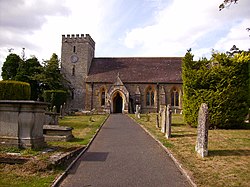
Buildings
Titley's parish church, dedicated to Saint Peter was rebuilt in 1869. The Stagg Inn, known as The Balance until 1833, became in 2001 the first pub in the United Kingdom to be awarded a Michelin Star.[6]
Eywood House was built just west of the village in 1705. A landscaped park was laid out around the house, and an existing kettle lake, Titley Pool, was enlarged. The house was demolished in 1958.[7] Titley Pool is now a nature reserve.[8]
Titley village hall is situated directly behind The Stagg Inn and is available for hire, as well as being regularly used by the parish council and other local organisations such as the WI, Scouts & Brownies, garden and bowls clubs.
Titley Junction railway station
A mile-long section of the former Leominster and Kington Railway was reopened in 2005. Known as The Kingfisher Line, the section is privately owned and is open to the public only by prior arrangement.[9]
↑"Stagg Inn & Restaurant". WhatPub. CAMRA. Archived from the original on 8 November 2015. Retrieved 3 July 2018. Originally called the Balance Inn, as wool would have been weighed here, the inn was renamed and refaced in 1833, by the diarist Eliza Greenly
↑Dixon, Rachel (24 January 2008). "Q&A: Michelin stars". London: The Guardian. Retrieved 25 May 2010.
This page is based on this Wikipedia article Text is available under the CC BY-SA 4.0 license; additional terms may apply. Images, videos and audio are available under their respective licenses.