| Tobaru | |
|---|---|
| Highest point | |
| Elevation | 1,035 m (3,396 ft) |
| Coordinates | 1°38′N127°40′E / 1.63°N 127.67°E |
| Geography | |
| Location | Halmahera, Indonesia |
| Geology | |
| Mountain type | unknown |
| Last eruption | unknown |
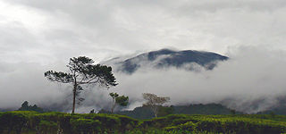
Mount Tobaru or Mount Lolodai is located in the northern part of Halmahera island, west of Dukono volcano. Little is known about this volcano because of its remote location.
A caldera is a large cauldron-like hollow that forms shortly after the emptying of a magma chamber in a volcano eruption. When large volumes of magma are erupted over a short time, structural support for the rock above the magma chamber is gone. The ground surface then collapses into the emptied or partially emptied magma chamber, leaving a large depression at the surface. Although sometimes described as a crater, the feature is actually a type of sinkhole, as it is formed through subsidence and collapse rather than an explosion or impact. Compared to the thousands of volcanic eruptions that occur each century, the formation of a caldera is a rare event, occurring only a few times per century. Only seven caldera-forming collapses are known to have occurred between 1911 and 2016. More recently, a caldera collapse occurred at Kīlauea, Hawaii in 2018.

The Ring of Fire is a tectonic belt, about 40,000 km (25,000 mi) long and up to about 500 km (310 mi) wide, which circumscribes the Pacific Ocean. It contains between 750 and 915 volcanoes, around two-thirds of the world total, and 90% of the world's earthquakes, including 81% of its largest, take place within the belt.

The Indonesian island of Java is almost entirely of volcanic origin, and contains numerous volcanoes, 45 of which are considered active volcanoes. As is the case for many other Indonesian islands, volcanoes have played a vital role in the geological and human history of Java. Indeed, land is created on Java as a result of lava flows, ash deposits, and mud flows (lahars). Volcanoes are a major contributor to the immense fertility of Java, as natural erosion transports volcanic material as alluvium to the island's plains, forming thick layers of fertile sediment. The benefit is not just in the immediate vicinity of the volcano, with fine ash emitted from eruptions being dispersed over wide areas.

The Bromo, or Mount Bromo is an active somma volcano and part of the Tengger mountains, in East Java, Indonesia. At 2,329 meters (7,641 ft) it is not the highest peak of the massif, but is the most active and famous. The area is one of the most visited tourist destinations in East Java, and the volcano is included in the Bromo Tengger Semeru National Park. The name Bromo comes from the Javanese pronunciation of Brahma, the Hindu god of creation. At the mouth of the crater, there is an idol of Ganesha, the Hindu god of wisdom which is being worshipped by the Javanese Hindus. Mount Bromo is located in the middle of a plain called "Sea of Sand", a nature reserve that has been protected since 1919.

Mount Merapi, is an active stratovolcano located on the border between the province of Central Java and the Special Region of Yogyakarta, Indonesia. It is the most active volcano in Indonesia and has erupted regularly since 1548. It is located approximately 28 km (17 mi) north of Yogyakarta city which has a population of 2.4 million, and thousands of people live on the flanks of the volcano, with villages as high as 1,700 m (5,577 ft) above sea level.

Mount Agung is an active volcano in Bali, Indonesia, southeast of Mount Batur volcano, also in Bali. It is the highest point on Bali, and dominates the surrounding area, influencing the climate, especially rainfall patterns. From a distance, the mountain appears to be perfectly conical. From the peak of the mountain, it is possible to see the peak of Mount Rinjani on the nearby island of Lombok, to the east, although both mountains are frequently covered in clouds. Agung is a stratovolcano, with a large and deep crater. Its most recent eruptions occurred from 2017–2019.

Mount Rinjani is an active volcano in Indonesia on the island of Lombok. Administratively the mountain is in the Regency of North Lombok, West Nusa Tenggara. It rises to 3,726 metres (12,224 ft), making it the second highest volcano in Indonesia. It is also the highest point in the Indonesian province of West Nusa Tenggara.

The Kelud is an mountain stratovolcano located in Kediri, East Java, Indonesia. Like many Indonesian volcanoes and others on the Pacific Ring of Fire, Kelud is known for large explosive eruptions throughout its history. More than 30 eruptions have occurred since 1000 AD. In 2007, an effusive explosion filled the crater with a lava dome. It last erupted on 13 February 2014, destroying the lava dome and ejecting boulders, stones and ashes up to West Java about 500 kilometres (310 mi) from Mount Kelud. The crater filled with water during the rainy season.
The Decade Volcanoes are 16 volcanoes identified by the International Association of Volcanology and Chemistry of the Earth's Interior (IAVCEI) as being worthy of particular study in light of their history of large, destructive eruptions and proximity to densely populated areas. The Decade Volcanoes project encourages studies and public-awareness activities at these volcanoes, with the aim of achieving a better understanding of the volcanoes and the dangers they present, and thus being able to reduce the severity of natural disasters.

The Semeru, or Mount Semeru is an active volcano located in East Java, Indonesia. It is located in a subduction zone, where the Indo-Australian plate subducts under the Eurasia plate. It is the highest mountain on the island of Java. The name "Semeru" is derived from Meru, the central world mountain in Hinduism, or Sumeru, the abode of gods. This stratovolcano is also known as Mahameru, meaning "The Great Mountain" in Sanskrit. It is one of the more popular hiking destinations in Indonesia.

A somma volcano, also known as a sommian, is a volcanic caldera that has been partially filled by a new central cone. The type is named after Mount Somma ("Summit"), a stratovolcano in southern Italy with a summit caldera in which the upper cone of Mount Vesuvius has grown. Other examples of somma volcanoes can be found on Russia's Kamchatka Peninsula and the Kuril Islands, stretching south from Kamchatka to Hokkaidō, Japan.

Mount Merbabu is a dormant stratovolcano in Central Java province on the Indonesian island of Java. The name Merbabu could be loosely translated as 'Mountain of Ash' from the Javanese combined words; Meru means "mountain" and awu or abu means "ash".

Mount Sinabung is a Pleistocene-to-Holocene stratovolcano of andesite and dacite in the Karo plateau of Karo Regency, North Sumatra, Indonesia, 40 kilometres (25 mi) from the Lake Toba supervolcano. Many old lava flows are on its flanks and the last known eruption, before recent times, occurred 1200 years before present, between 740 - 880 CE. Solfataric activities were last observed at the summit in 1912; recent documented events include an eruption in the early hours of 29 August 2010 and eruptions in September and November 2013, January, February and October 2014. The volcano has recently claimed the life of at least 23 people in a number of events since 2014. Between 2013 and 2014, the alert for a major event was increased with no significant activity. On 2 June 2015, the alert was again increased, and on 26 June 2015, at least 10,000 people were evacuated, fearing a major eruption. The long eruption of Mount Sinabung is similar to that of Mount Unzen in Japan, which erupted for five years after lying dormant for 400 years. A major eruption began on 10 August 2020.

Mount Arjuno-Welirang is a stratovolcano in the province of East Java on Java, Indonesia. Mount Arjuno-Welirang lies about 50 kilometers south of Surabaya, and 20 kilometers north of Malang. It is a twin volcano, with the 'twins' being Arjuno and Welirang. There is at least one other stratovolcano in the area, and there are around 10 pyroclastic cones nearby. They are located in a 6 km line between Arjuno and Welirang. The Arjuno-Welirang volcanic complex itself lies in the older two volcanoes, Mount Ringgit to the east and Mount Linting to the south. The summit lacks vegetation. Fumarolic areas with sulfur deposits are found in several locations on Welirang.

Bromo Tengger Semeru National Park is a national park located in East Java, Indonesia, to the east of Malang and Lumajang, to the south of Pasuruan and Probolinggo, and to the southeast of Surabaya, the capital of East Java. It is the only conservation area in Indonesia that has a sand sea, the Tengger Sand Sea, across which is the caldera of an ancient volcano (Tengger) from which four new volcanic cones have emerged. This unique feature covers a total area of 5,250 hectares at an altitude of about 2,100 meters (6,900 ft). The massif also contains the highest mountain in Java, Mount Semeru, four lakes and 50 rivers. It is named after the Tengger tribe. The explosion of the volcano that created the caldera, happened ca. 45.000 years ago, in an event similar to the Krakatau eruption.
Mount Gede Pangrango National Park is a national park in West Java, Indonesia. The park is centred on two volcanoes—Mount Gede and Mount Pangrango—and is 150 km² in area.

Several types of volcanic eruptions—during which lava, tephra, and assorted gases are expelled from a volcanic vent or fissure—have been distinguished by volcanologists. These are often named after famous volcanoes where that type of behavior has been observed. Some volcanoes may exhibit only one characteristic type of eruption during a period of activity, while others may display an entire sequence of types all in one eruptive series.
Segara Anak is a crater lake in the caldera that formed during the explosive volcanic eruption of Mount Samalas in 1257. The caldera is next to Mount Rinjani on Lombok Island in Indonesia. "Segara Anak" means "child of the sea" and refers to the blue lake's resemblance to the sea. The volcanic cone Gunung Barujari is at the eastern end of the lake and is responsible for its crescent shape. The lake temperature is 20–22 °C (68–72 °F), which is 5-7 °C higher than normal for a lake at its altitude. Hot magma below the lake is responsible for this anomaly. Gas bubbles escape from the lake floor, helping the lake to have a pH of 7-8.
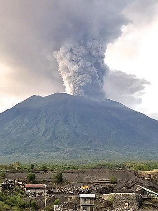
Mount Agung, a volcano on the island of Bali in Indonesia, erupted five times in late November 2017, causing thousands to evacuate, disrupting air travel and causing environmental damage. As of 27 November 2017, the alert level was at its highest and evacuation orders were in place.
| Authority control databases: Geographic |
|---|
| | This North Maluku location article is a stub. You can help Wikipedia by expanding it. |