
A volcano is commonly defined as a vent or fissure in the crust of a planetary-mass object, such as Earth, that allows hot lava, volcanic ash, and gases to escape from a magma chamber below the surface.

Mount Etna, or simply Etna, is an active stratovolcano on the east coast of Sicily, Italy, in the Metropolitan City of Catania, between the cities of Messina and Catania. It is located above the convergent plate margin between the African Plate and the Eurasian Plate. It is one of the tallest active volcanoes in Europe, and the tallest peak in Italy south of the Alps with a current height of 3,403 m (11,165 ft), though this varies with summit eruptions. For instance, in 2021 the southeastern crater reached a height of 3,357 m, but was then surpassed by the Voragine crater after the summer 2024 eruptions.

The Ring of Fire is a tectonic belt of volcanoes and earthquakes.
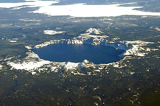
Mount Mazama is a complex volcano in the western U.S. state of Oregon, in a segment of the Cascade Volcanic Arc and Cascade Range. The volcano is in Klamath County, in the southern Cascades, 60 miles (97 km) north of the Oregon–California border. Its collapse, due to the eruption of magma emptying the underlying magma chamber, formed a caldera that holds Crater Lake. Mount Mazama originally had an elevation of 12,000 feet (3,700 m), but following its climactic eruption this was reduced to 8,157 feet (2,486 m). Crater Lake is 1,943 feet (592 m) deep, the deepest freshwater body in the U.S. and the second deepest in North America after Great Slave Lake in Canada.
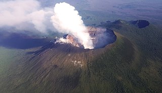
Mount Nyiragongo is an active stratovolcano with an elevation of 3,470 m (11,385 ft) in the Virunga Mountains associated with the Albertine Rift. It is located inside Virunga National Park, in the Democratic Republic of the Congo, about 12 km (7.5 mi) north of the town of Goma and Lake Kivu and just west of the border with Rwanda. The main crater is about two kilometres (1 mi) wide and usually contains a lava lake. The crater presently has two distinct cooled lava benches within the crater walls – one at about 3,175 m (10,417 ft) and a lower one at about 2,975 m (9,760 ft).
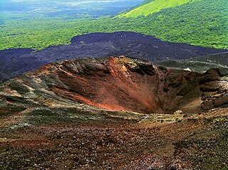
Cerro Negro is an active volcano in the Cordillera de los Maribios mountain range in Nicaragua, about 10 km (6.2 mi) from the village of Malpaisillo. It is a very new volcano, the youngest in Central America, having first appeared in April 1850. It consists of a gravelly basaltic cinder cone, which contrasts greatly with the surrounding verdant hillsides, and gives rise to its name, which means Black Hill. Cerro Negro has erupted frequently since its first eruption. One unusual aspect of several eruptions has been the emission of ash from the top of the cone, while lava erupts from fractures at the base.

An active volcano is a volcano that has erupted during the Holocene, is currently erupting, or has the potential to erupt in the future. A volcano that is not currently erupting but could erupt in the future is known as a dormant volcano. Volcanoes that will not erupt again are known as extinct volcanoes.
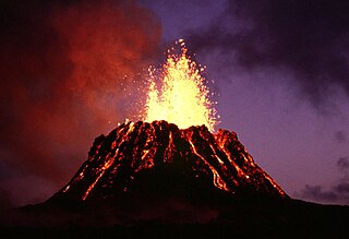
Puʻu ʻŌʻō is a volcanic cone on the eastern rift zone of Kīlauea volcano in the Hawaiian Islands. The eruption that created Puʻu ʻŌʻō began on January 3, 1983, and continued nearly continuously until April 30, 2018, making it the longest-lived rift-zone eruption of the last two centuries.

Shishaldin Volcano, or Mount Shishaldin, is one of six active volcanoes on Unimak Island in the eastern Aleutian Islands of Alaska. It is the highest mountain peak of the Aleutian Islands, rising to a height of 9,373 ft above sea level. Shishaldin's magma supply is generated via flux melting above the Aleutian Trench, where the Pacific Plate subducts beneath the North American Plate. Due to its remote location and frequently inclement weather, the Alaska Volcano Observatory (AVO) monitors the volcano remotely via satellite and a seismic network deployed in 1997. Shishaldin is one of the most active volcanoes in the Aleutian Islands, with 40 confirmed eruptions in the last 11,700 years. Notably, Shishaldin produced a sub-Plinian eruption in 1999.

Mount Rinjani is an active volcano in Indonesia on the island of Lombok. Administratively the mountain is in the Regency of North Lombok, West Nusa Tenggara. It rises to 3,726 metres (12,224 ft), making it the second highest volcano in Indonesia. It is also the highest point in the Indonesian province of West Nusa Tenggara. Adjacent to the volcano is a 6-by-8.5-kilometre caldera, which is filled partially by the crater lake known as Segara Anak or Anak Laut, due to the color of its water, as blue as the sea (laut). This lake is approximately 2,000 metres (6,600 ft) above sea level and estimated to be about 200 metres (660 ft) deep; the caldera also contains hot springs. The lake and mountain are sacred to the Sasak people and Hindus, and are the site of religious rituals. UNESCO made Mount Rinjani Caldera a part of the Global Geoparks Network in April 2018. Its catastrophic eruption in 1257 was the largest volcanic eruption in the last 2000 years.

Mauna Ulu is a volcanic cone in the eastern rift zone of the Kīlauea volcano on the island of Hawaii. It falls within the bounds of Hawaiʻi Volcanoes National Park. Mauna Ulu was in a state of eruption from May 1969 to July 1974.

Anak Krakatau is a volcanic island in Indonesia. On 29 December 1927, Anak Krakatau first emerged from the caldera formed in 1883 by the explosive volcanic eruption that destroyed the island of Krakatoa. There has been sporadic eruptive activity at the site since the late 20th century, culminating in a large underwater collapse of the volcano, which caused a deadly tsunami in December 2018. There has been subsequent activity since. Owing to its young age the island is one of several in the area that are of interest to, and the subject of extensive study by volcanologists.

Cerro Azul, sometimes referred to as Quizapu, is an active stratovolcano in the Maule Region of central Chile, immediately south of Descabezado Grande. Part of the South Volcanic Zone of the Andes, its summit is 3,788 meters (12,428 ft) above sea level, and is capped by a summit crater that is 500 meters (1,600 ft) wide and opens to the north. Beneath the summit, the volcano features numerous scoria cones and flank vents.
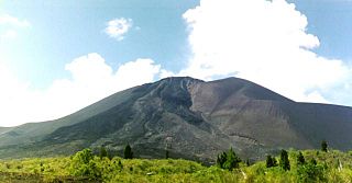
Soputan is a stratovolcano in Indonesia. It is on the northern arm of Sulawesi island and rises to an elevation of 1,785 m (5,853 ft). The geologically young and mostly unvegetated cone is primarily constructed of andesite and basalt rock. It sits on the southern rim of the Tondano caldera, which formed in the Quaternary period. The volcano is one of Sulawesi's most active, with 39 confirmed eruptions in the last 600 years. Eruptive activity at Soputan typically consists of pyroclastic flows, lava flows, lava domes and Strombolian-style explosions.

Mount Slamet is an active stratovolcano that summits in the Pemalang Regency of Central Java, Indonesia. It has a cluster of around three dozen cinder cones on the lower southeast and northeast flanks and a single cinder cone on the western flank. The volcano is composed of two overlapping edifices. Four craters are found at the summit. Mount Slamet is a location with the coldest average temperature on the island of Java and one of the areas with the highest annual rainfall in Indonesia, namely 8,134.00 millimeters (mm) per year.

Mount Ibu is a stratovolcano at the north-west coast of Halmahera island, Indonesia. The summit is truncated and contains nested craters. The inner crater is 1 km (0.62 mi) wide and 400 m (1,312 ft) deep, while the outer is 1.2 km (0.75 mi) wide. A large parasitic cone is at the north-east of the summit and a smaller one at the south-west. The latter feeds a lava flow down the west flank. A group of maars are on the western and northern side of the volcano. Mount Ibu sits within the Pacific Ocean's "Ring of Fire" that has 127 active volcanoes.

Mount Tendürek is a shield volcano on the border of Ağrı and Van provinces in eastern Turkey, near the border with Iran. The volcano, which is mostly known for being near the supposed wreck site of Noah's Ark, is very large; its lava flows cover roughly 650 km2 (251 sq mi) across a swath of flat land. The mountain's two main features are the main summit crater Greater Tendürek, and a smaller crater known as Lesser Tendürek which lies to the east of the main crater. The slopes are very gentle and resemble a shield, after which the type is named. Mount Tendürek is known to have erupted viscous lava like that of volcanoes on the island of Hawaii.
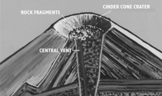
A cinder cone is a steep conical hill of loose pyroclastic fragments, such as volcanic clinkers, volcanic ash, or scoria that has been built around a volcanic vent. The pyroclastic fragments are formed by explosive eruptions or lava fountains from a single, typically cylindrical, vent. As the gas-charged lava is blown violently into the air, it breaks into small fragments that solidify and fall as either cinders, clinkers, or scoria around the vent to form a cone that often is symmetrical; with slopes between 30 and 40°; and a nearly circular ground plan. Most cinder cones have a bowl-shaped crater at the summit.

Lokon-Empung is a volcano on the island of Sulawesi. It is one of the most active in Indonesia. It consists of two volcanic cones, the older Lokon and the younger Empung. The active crater of Tompaluan is situated in the saddle between the two cones.


