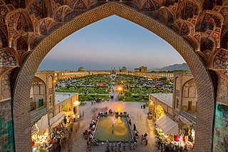
Isfahan, from its ancient designation Aspadana and later Spahan in middle Persian, rendered in English as Ispahan, is a major city in Greater Isfahan Region, Isfahan Province, Iran. It is located 406 kilometres south of Tehran and it is the capital of Isfahan Province. Isfahan has a population of approximately 1.9 million, making it the third-largest city in Iran, after Mashhad and Tehran, and the second-largest metropolitan area.

Jalāl al-Dawla Mu'izz al-Dunyā Wa'l-Din Abu'l-Fatḥ ibn Alp Arslān, better known by his regnal name of Malik-Shah I, was sultan of the Seljuk Empire from 1072 to 1092.

Fars Province, also known as Pars as well as Persis and Persia, is one of the thirty-one provinces of Iran. With an area of 122,400 km², it is located in Iran's southwest, in Region 2, and its administrative center is Shiraz. As of 2011, Fars had a population of 4.6 million people, of whom 67.6% were registered as urban dwellers (urban/suburbs), 32.1% villagers, and 0.3% nomad tribes.

Qazvin Province is one of the 31 provinces of Iran. It is in the north-west of the country, and its center is the city of Qazvin. The province was created in 1993 out of part of Tehran Province. The counties of Qazvin Province are Qazvin County, Takestan County, Abyek County, Buin Zahra County, Mobarakeh County, Alborz County & Avaj County. The largest cities are Qazvin, Takestan, Abyek, Alvand, Iran, Bidestan, Mobarakeh, Mohammadiyeh & Eqbaliyeh.

Panchkula district was formed as the 17th district of Haryana state in India on 15 August 1995. It comprises two sub divisions and two tehsils: Panchkula and Kalka. It has 264 villages out of which twelve are un-inhabited and ten wholly merged with towns or treated as census towns according to the 1991 census. There are five towns in the district: Barwala, Kalka, Panchkula, Pinjore and Raipur Rani. The total population of the district is 319,398 out of which 173,557 are males and 145,841 are females.

Iranian architecture or Persian architecture is the architecture of Iran and parts of the rest of West Asia, the Caucasus and Central Asia. Its history dates back to at least 5,000 BC with characteristic examples distributed over a vast area from Turkey and Iraq to Uzbekistan and Tajikistan, and from the Caucasus to Zanzibar. Persian buildings vary from peasant huts to tea houses, and garden pavilions to "some of the most majestic structures the world has ever seen". In addition to historic gates, palaces, and mosques, the rapid growth of cities such as the capital Tehran has brought about a wave of demolition and new construction.

Zayanderud, also spelled as Zayandeh-Rood or Zayanderood, is the largest river of the Iranian Plateau in central Iran.
Isfahan University of Art (AUI) is a public University in Isfahan, Iran. It operated under the name of "Farabi University" before 1978, then it became a campus of the University of Art. It was separated and became independent in 1999. The university owns some of the greatest houses in Isfahan, mostly of the Safavid period. The university's buildings are spread out over the city, most of which are old historic sites such as Tohid Khaane Building, David House, Martha Peters House, Haratian House, Sookiaas House, Haghighi House, France School and Ayyoubi and Melal House.
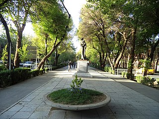
Chahar Bagh Boulevard is a historical avenue in Isfahan constructed in the Safavid era of Iran. This histories street is very similar to the Champs Elysees in paris,which some visitors called the champs Elysees of isfahan.
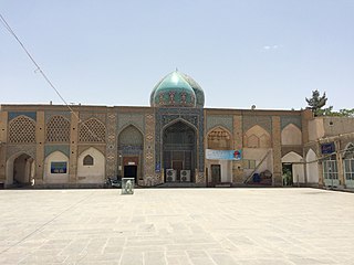
The shrine of Darb-e Imam, located in the Dardasht quarter of Isfahan, Iran, is a funerary complex, with a cemetery, shrine structures, and courtyards belonging to different construction periods and styles. The first structures were built by Jalal al-Din Safarshah, during the Qara Qoyunlu reign in 1453.

Lenjan County is a county in Isfahan Province in Iran. The capital of the county is Zarrin Shahr. Lenjan County is also the location of Isfahan Steel Mill. It is located on the banks of the Zayandeh River, which the largest river in Isfahan Province. Farming is an important source of income, and the most important product in Lenjan is rice. As of the 2016 census, the county's population was 262,912, in 81,101 households.
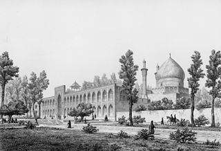
Chahār BāghSchool or the Chahār BāghMadrasa, also known as Madrasa Madar-i Shah, is a 17-18th century cultural complex in Isfahan, Iran.

The Khaju Bridge is one of the historical bridges on the Zayanderud, the largest river of the Iranian Plateau, in Isfahan, Iran. Serving as both a bridge and a weir, it links the Khaju quarter on the north bank with the Zoroastrian quarter across the Zayanderud. It is located at the end of Kamal Ismail Street in Isfahan.

The Monar Jonban, is a monument located in Esfahan, in central Iran. Construction began in the 14th century Safavid or Ilkhanate dynasties of Iran to cover the grave of Sufi Amu Abdollah Soqla. Its notable feature is that if one of the minarets is shaken, the other minaret will shake as well.

The Fire Temple of Isfahan is a Sassanid-era archaeological complex located on a hill of the same name about eight kilometers west of city center of Isfahan, Iran.

Bahāʾ al‐Dīn Muḥammad ibn Ḥusayn al‐ʿĀmilī was an Arab Iranian Shia Islamic scholar, philosopher, architect, mathematician, astronomer and poet who lived in the late 16th and early 17th centuries in Safavid Iran. He was born in Baalbek, Ottoman Syria but immigrated in his childhood to Safavid Iran with the rest of his family. He was one of the earliest astronomers in the Islamic world to suggest the possibility of the Earth's movement prior to the spread of the Copernican theory. He is considered one of the main co-founders of Isfahan School of Islamic Philosophy. In later years he became one of the teachers of Mulla Sadra.
Tudeshk Rural District is a rural district (dehestan) in Kuhpayeh District, Isfahan County, Isfahan Province, Iran. At the 2006 census, its population was 3,746, in 1,148 families. The rural district has 62 villages.
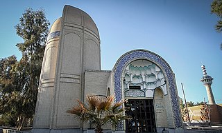
Takht-e Foulad is a historical cemetery in Isfahan, Iran. The cemetery is at least 800 years old. In the 13th century in the Ilkhanid era Takht-e Foulad was the most important cemetery in Isfahan and all of the famous personalities have a mausoleum in this cemetery. Unfortunately all of the mausoleums from the Ilkhanid era, except Baba Rokn ed-Din mausoleum, which is the oldest structure in Takht-e Foulad, have been destroyed. In the Safavid era there were 400 mausoleums in Takht-e Foulad, but there are now only 8 mausoleums from the Safavid era. In the Qajar era a large part of the cemetery was destroyed, but the cemetery hasn't lost its importance and by the end of Pahlavi era it was the most important cemetery in Isfahan. There are 20 structures from the Qajar era and 17 structures from the Pahlavi era in the cemetery. Before the Safavid age the cemetery had been known as Lessan ol-Arz and Baba Rokn ed-Din, but from the Safavid age until now its name is Takht-e Foulad.
Defense Industry Complex, Isfahan is a village and company town in Ashiyan Rural District, in the Central District of Lenjan County, Isfahan Province, Iran. At the 2006 census, its population was 2,444, in 642 families.
Baharestan Rural District is a rural district (dehestan) in the Central District of Nain County, Isfahan Province, Iran. At the 2006 census, its population was 1,603, in 572 families. The rural district has 32 villages.


